MyTopo
Tunnel Hill Georgia US Topo Map
Couldn't load pickup availability
Also explore the Tunnel Hill Forest Service Topo of this same quad for updated USFS data
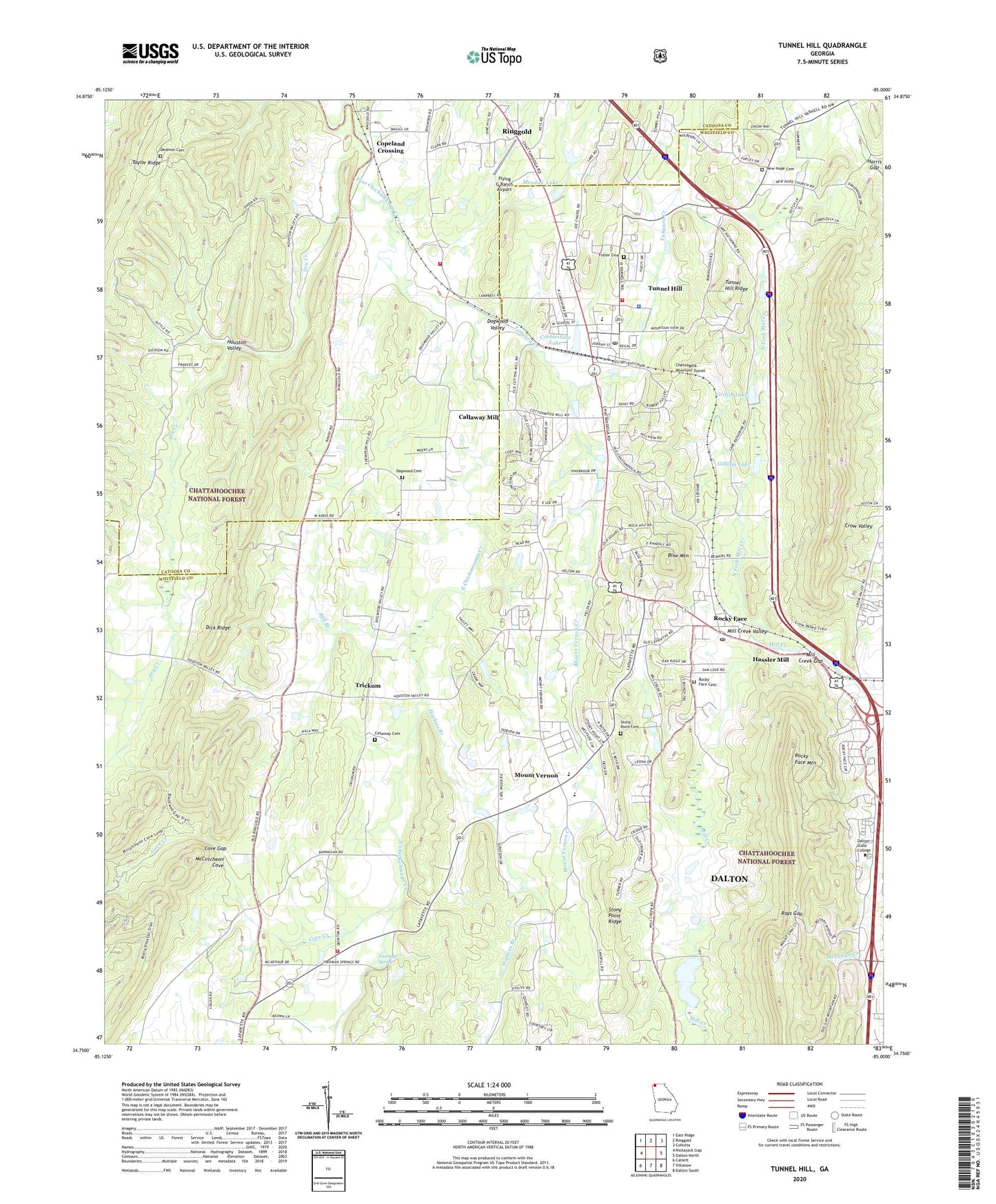
2024 topographic map quadrangle Tunnel Hill in the state of Georgia. Scale: 1:24000. Based on the newly updated USGS 7.5' US Topo map series, this map is in the following counties: Whitfield, Catoosa. The map contains contour data, water features, and other items you are used to seeing on USGS maps, but also has updated roads and other features. This is the next generation of topographic maps. Printed on high-quality waterproof paper with UV fade-resistant inks.
Quads adjacent to this one:
West: Nickajack Gap
Northwest: East Ridge
North: Ringgold
Northeast: Cohutta
East: Dalton North
Southeast: Dalton South
South: Villanow
Southwest: Catlett
This map covers the same area as the classic USGS quad with code o34085g1.
Contains the following named places: Bell Branch, Blue Mountain, Callaway Cemetery, Callaway Mill, Catoosa County Fire Department Station 5, Chetoogeta Mountain Tunnel, City of Tunnel Hill, Cobblestone Lake, Cobblestone Lake Dam, Cook Lake, Copeland Crossing, Cove Creek, Cove Gap, Dalton State College, Dedmon Cemetery, Dogwood Cemetery, Dogwood Christian Academy, Dogwood Church, Dogwood Valley, Dry Creek, Dunnegan Church, Fellowship Church, First Baptist Church of Tunnel Hill, Flying G Ranch Airport, Foster Cemetery, Freeman Spring, Georgia State Patrol Troop A Post 5, Gillilan Lake, Griffin Lake, Griffin Lake Dam, Harris Gap, Hassler Mill, Hiawassee Land Company Lake, Hickory Grove Church, Hickory Grove School, Hopkins Branch, Houston Valley, Houston Valley Church, Lakeside Church, Liberty Church, McCutcheon Cove, Meadow Lake, Mill Creek Gap, Mill Creek Valley, Mill Creek Watershed Dam Number 10, Mill Creek Watershed Dam Number Seven, Mont Lily Station, Mount Salem Church, Mount Vernon, Mount Vernon Church, Mount Vernon Creek, New Hope Cemetery, New Hope Church, North Fork Mill Creek, North Whitfield Church, Pine Hill Church, Rays Gap, Rocky Acres Bible Camp, Rocky Face, Rocky Face Baptist Church, Rocky Face Cemetery, Rocky Face Mountain, Rocky Face Post Office, Spriggs Mill, Stony Point Cemetery, Stony Point Church, Stony Point Ridge, Tanyard Creek, Trickum, Trickum School, Tunnel Hill, Tunnel Hill Elementary School, Tunnel Hill Police Department, Tunnel Hill Post Office, Tunnel Hill Ridge, West Side High School, Westside Elementary School, Westside Middle School, Whitfield County Fire Department Station 6, Whitfield County Fire Department Station 7, WTTI Radio Towers, WTTI-AM (Dalton), ZIP Codes: 30740, 30755