MyTopo
Etowah Tennessee US Topo Map
Couldn't load pickup availability
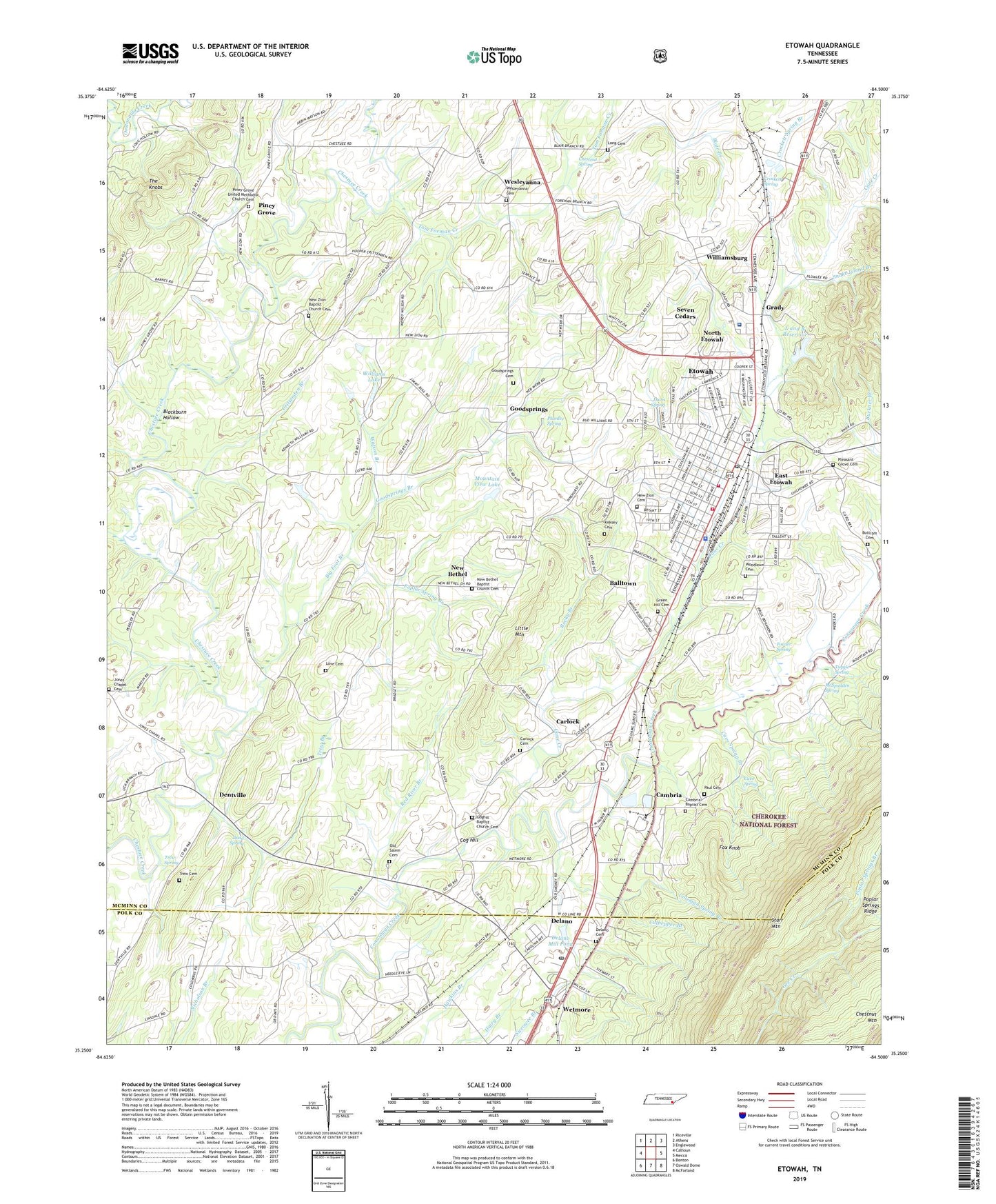
2019 topographic map quadrangle Etowah in the state of Tennessee. Scale: 1:24000. Based on the newly updated USGS 7.5' US Topo map series, this map is in the following counties: McMinn, Polk. The map contains contour data, water features, and other items you are used to seeing on USGS maps, but also has updated roads and other features. This is the next generation of topographic maps. Printed on high-quality waterproof paper with UV fade-resistant inks.
Quads adjacent to this one:
West: Calhoun
Northwest: Riceville
North: Athens
Northeast: Englewood
East: Mecca
Southeast: McFarland
South: Oswald Dome
Southwest: Benton
Contains the following named places: Balltown, Belleview Estates, Big Foot Branch, Blackburn Hollow, Blair Branch, Brookhill Baptist Church, Buttram Cemetery, Cambria, Cambria Baptist Church, Cambria Baptist Church Cemetery, Cambria Station, Cameron School, Cane Creek, Carlock, Carlock Cemetery, Carlock School, Cave Spring, Cave Spring Branch, Chestnut Spring, Chestuee Golf and Country Club, City of Etowah, Cog Hill, Cog Hill Church, Coghill Baptist Church Cemetery, Coleman Spring Branch, Commissioner District 4, Crittenden Branch, Crockett Spring, Crockett Spring Branch, Culpepper Branch, Davis Spring, Delano, Delano Baptist Church, Delano Cemetery, Delano Census Designated Place, Delano Mill Pond, Delano Post Office, Delano School, Delano Station, Dentville, Dodd Spring, Double Springs Branch, East and West School, East Etowah, East Etowah School, East View Church, Etowah, Etowah City Hall, Etowah Division, Etowah Fire Department, Etowah Junior High School, Etowah Police Department, Etowah Post Office, Etowah Rescue Squad and Rural Fire Department, Etowah Water Works, First Baptist Church, Fowler Spring, Fox Knob, Gee Creek Wilderness, Goat Knob, Goodsprings, Goodsprings Baptist Church, Goodsprings Branch, Goodsprings Cemetery, Goodsprings School, Goosetown, Grady, Gravel Hill School, Green Hill Cemetery, Harwell Chapel Church, Hiawassee Ranger Station, Hiwassee Work Center, John Harris Church, Jones Chapel, Jones Chapel Cemetery, Kirksey Cemetery, L and N Reservoir, L and N Reservoir Dam, Little Mountain, Long Cemetery, Longs Mills, Love Cemetery, McSpadden Spring, Midway Drive-In, Mount Olive Church, Mountain View Elementary School, Mountain View Lake, New Bethel, New Bethel Baptist Church, New Bethel Baptist Church Cemetery, New Salem Church, New Zion Baptist Church, New Zion Baptist Church Cemetery, New Zion Cemetery, North Etowah, North Etowah Baptist Church, North Etowah School, Old Salem Baptist Church Cemetery, Old Salem Church, Paul Cemetery, Piney Grove, Piney Grove School, Piney Grove United Methodist Church, Piney Grove United Methodist Church Cemetery, Pleasant Grove Church, Pleasant Grove United Methodist Church Cemetery, Plumlee Spring, Poplar Spring Branch, Poplar Springs Branch, Red River Branch, Rocky Branch, Saint Pauls Methodist Church, Seven Cedars, Snake Island Branch, Starr Mountain, Starr Regional Medical Center - Etowah, Tom Foeman Creek, Trew Branch, Trew Cemetery, Trew Spring, Tuggle Spring, Watson Branch, WCPH-AM (Etowah), Wesley Memorial Methodist Church, Wesleyanna, Wesleyanna Cemetery, Wesleyanna Methodist Church, Wesleyanna School, Wetmore, Wetmore Baptist Church, Williams Lake, Williamsburg, WMCC-FM (Etowah), Woodlawn Cemetery, Yancey, ZIP Codes: 37325, 37331