
MyTopo
Flag Pond Tennessee US Topo Map
Couldn't load pickup availability
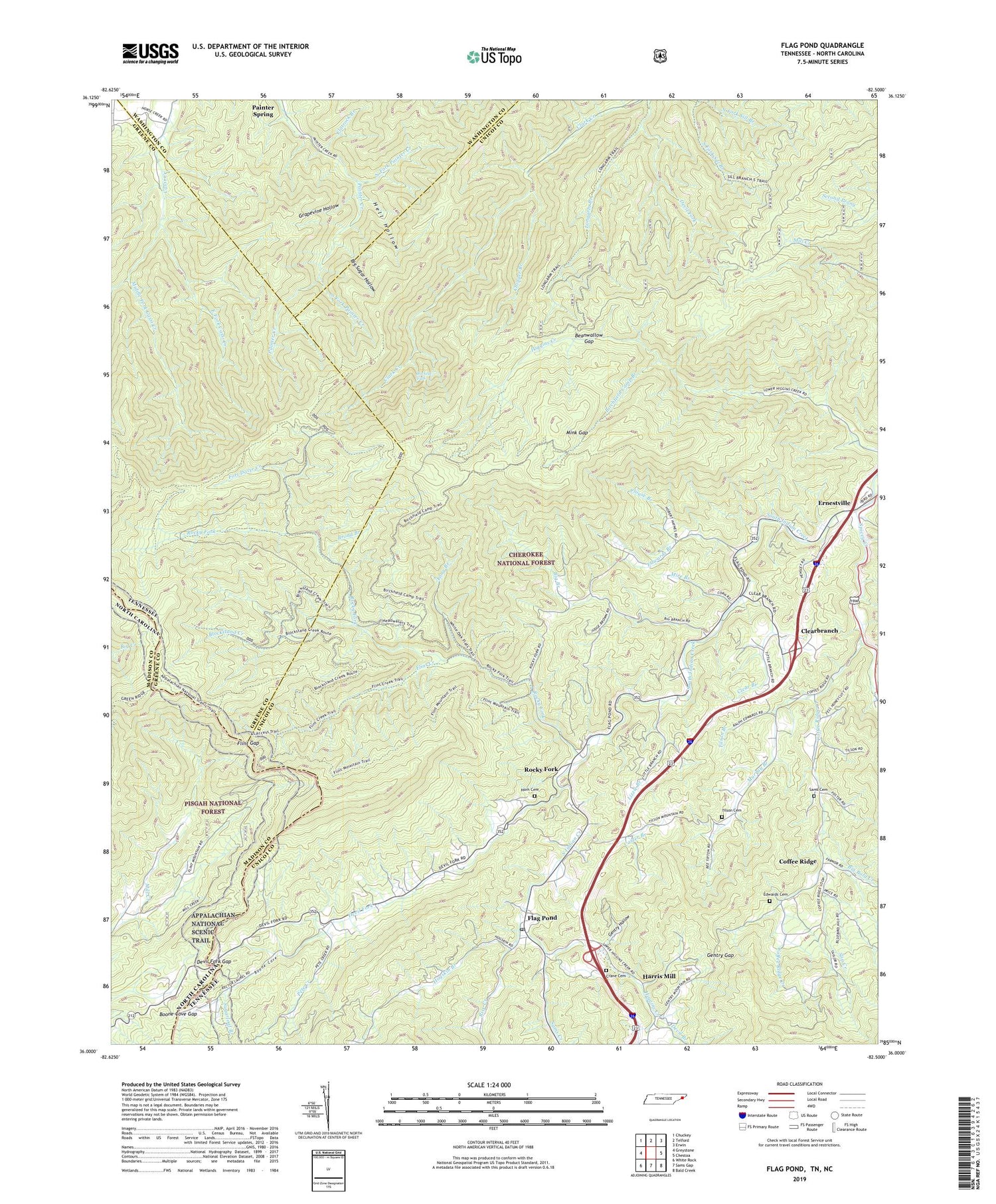
2019 topographic map quadrangle Flag Pond in the states of Tennessee, North Carolina. Scale: 1:24000. Based on the newly updated USGS 7.5' US Topo map series, this map is in the following counties: Unicoi, Greene, Madison, Washington. The map contains contour data, water features, and other items you are used to seeing on USGS maps, but also has updated roads and other features. This is the next generation of topographic maps. Printed on high-quality waterproof paper with UV fade-resistant inks.
Quads adjacent to this one:
West: Greystone
Northwest: Chuckey
North: Telford
Northeast: Erwin
East: Chestoa
Southeast: Bald Creek
South: Sams Gap
Southwest: White Rock
Contains the following named places: Beanwallow Gap, Big Bald Creek, Big Branch, Big Pine Ridge, Big Sugar Hollow, Birchfield Camp Branch, Blackpine Ridge, Blockstand Creek, Boone Cove, Boone Cove Gap, Briggs, Broad Branch, Buckeye Falls, Carter Branch, Chestnut Knob, Chigger Branch, Chigger Ridge, Clark Creek Trail, Clear Branch, Clear Branch Baptist Church, Clearbranch, Clouse Branch, Coffee Ridge, Coffee Ridge Baptist Church, Coffee Ridge Creek, Coffee Ridge School, Commissioner District 1, Crane Cemetery, Devil Branch, Devil Fork, Devil Fork Gap, Devils Branch, East Fork Cassi Creek, East Fork Higgins Creek, Edwards Branch, Edwards Cemetery, Ennis School, Ernestville, Faith Tabernacle, Flag Pond, Flag Pond Baptist Church, Flag Pond Division, Flag Pond Elementary School, Flag Pond Post Office, Flatrock Branch, Flint Creek, Flint Gap, Flint Gap Trail Shelter, Flint Mountain, Fort Davie Creek, Frozen Knob, Gentry Gap, Gentry Hollow, Gilbert Branch, Grapevine Hollow, Grassy Knob, Green Ridge, Green Ridge Knob, Harris Mill, Hell Hollow, Higgins Chapel School, Higgins Creek, Higgins Ridge, Highrock, Hogskin Branch, Horn Cemetery, Laurel Branch, Lizzie Branch, Locust Ridge, Loganton, Long Branch, Longarm Branch, Longarm Ridge, Middle Fork Cassi Creek, Middle Spring Ridge, Mink Gap, Mire Branch, Murray Branch, North Fork Painter Creek, Painter Spring, Pete Creek, Phillips Mili, Playyard Ridge, Rice Creek, Rich Mountain, Rocky Fork, Rocky Fork School, Roseville School, Sampson Mountain, Sampson Mountain Wilderness, Sams Cemetery, Sams Creek, Slip Creek, Slipper Spur Gap, Snakeden Ridge, South Fork Painter Creek, Spivey Creek, Sugarloaf Branch, Sweetwater School, Tilson Branch, Tilson Cemetery, Tilson Mountain, West Fork Cassi Creek, Willis Store, Wilson Knob, ZIP Code: 37657


