MyTopo
White Rock North Carolina US Topo Map
Couldn't load pickup availability
Also explore the White Rock Forest Service Topo of this same quad for updated USFS data
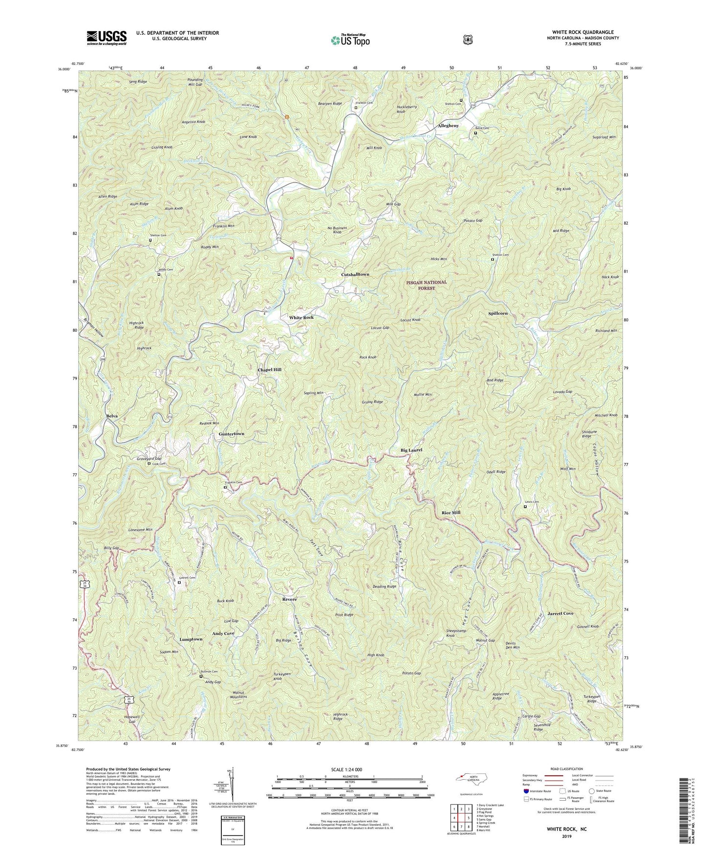
2022 topographic map quadrangle White Rock in the state of North Carolina. Scale: 1:24000. Based on the newly updated USGS 7.5' US Topo map series, this map is in the following counties: Madison. The map contains contour data, water features, and other items you are used to seeing on USGS maps, but also has updated roads and other features. This is the next generation of topographic maps. Printed on high-quality waterproof paper with UV fade-resistant inks.
Quads adjacent to this one:
West: Hot Springs
Northwest: Davy Crockett Lake
North: Greystone
Northeast: Flag Pond
East: Sams Gap
Southeast: Mars Hill
South: Marshall
Southwest: Spring Creek
This map covers the same area as the classic USGS quad with code o35082h6.
Contains the following named places: Allegheny, Allen Ridge, Alum Knob, Alum Ridge, Amos Creek, Andy Cove, Andy Gap, Angelico Knob, Appletree Ridge, Baker Creek, Barnes Branch, Bearpen Branch, Belva, Belva Cemetery, Big Knob, Big Laurel, Big Laurel Church, Big Ridge, Billy Gap, Billy King Branch, Brigman Chapel, Brigman Hollow, Buck Knob, Buckner Branch, Bullman Cemetery, Burton Cove, Calvin Creek, Capps Hollow, Cargle Gap, Chapel Hill, Chestnut Hill Church, Cook Cemetery, Crane Branch, Cutshall Branch, Cutshalltown, Deading Ridge, Devils Den Mountain, Duckmill Creek, East Prong Hickey Fork, Franklin Cemetery, Franklin Mountain, Gosnell Cemetery, Gosnell Knob, Grassy Ridge, Graveyard Gap, Gunter Branch, Guntertown, Hack Knob, Hensley Branch, Hickey Fork, Hickorylog Branch, Hicks Mountain, High Knob, Highrock, Highrock Ridge, Highshoal Branch, Hog Cove, Hopewell Church, Hopewell Gap, Huckleberry Knob, Jarrett Cove, Job Chapel, Johnson Branch, Laurel Elementary School, Laurel Volunteer Fire Department, Lewis Branch, Lewis Cemetery, Licklog Knob, Lisenbee Branch, Little Laurel Creek, Locust Gap, Locust Knob, Lone Knob, Lonesome Mountain, Lovada Gap, Low Gap, Lumptown, Middle Laurel Church, Middle Ridge, Mile Gap, Mill Knob, Mitchell Knob, Mollie Mountain, No Business Knob, Odell Ridge, Palmer Camp Branch, Pilot Ridge, Pine Branch, Piney Grove Church, Potato Gap, Pounding Mill Gap, Pounding Mill Trail, Redoak Mountain, Revere, Rice Cove, Rice Mill, Rice School, Richland Mountain, Rock Branch, Rock Knob, Rod Ridge, Roddy Branch, Roddy Cemetery, Roddy Mountain, Sapling Mountain, Sevenmile Ridge, Shade Branch, Shady Grove Church, Sheepstamp Knob, Shelton Branch, Shelton Cemetery, Shinbone Ridge, Sodom Branch, Sodom Mountain, Spillcorn, Spillcorn Creek, Tarlton Branch, Tett Cove, Township 11 Revere-Rice Cove, Township 2-Laurel, Turkeypen Knob, Turkeypen Ridge, Wallin Branch, Walnut Gap, Watermelon Branch, West Prong Hickey Fork, White Rock, Wild Branch, Wolf Branch, Wolf Mountain