
MyTopo
Iron Mountain Gap Tennessee US Topo Map
Couldn't load pickup availability
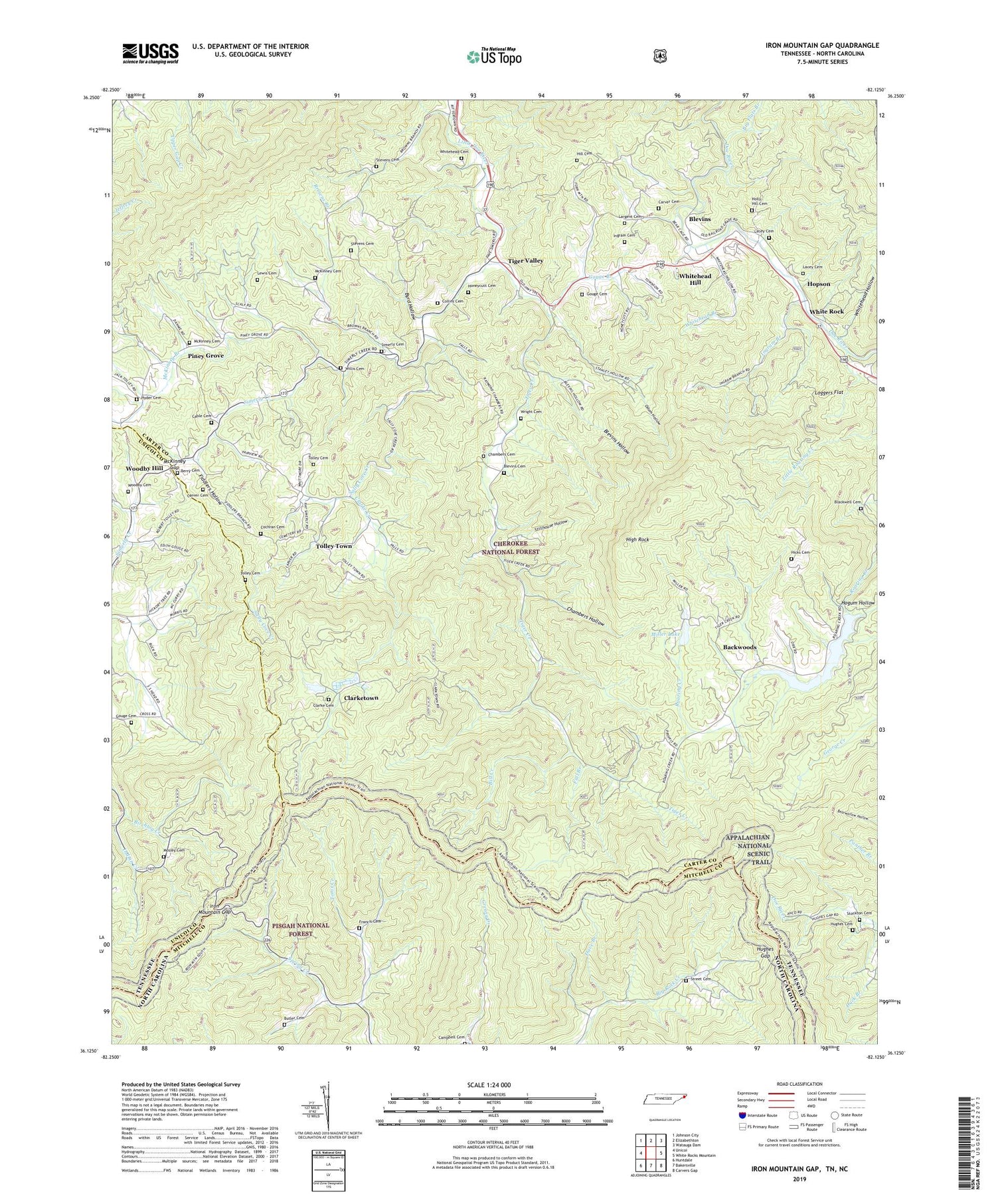
2019 topographic map quadrangle Iron Mountain Gap in the states of Tennessee, North Carolina. Scale: 1:24000. Based on the newly updated USGS 7.5' US Topo map series, this map is in the following counties: Carter, Mitchell, Unicoi. The map contains contour data, water features, and other items you are used to seeing on USGS maps, but also has updated roads and other features. This is the next generation of topographic maps. Printed on high-quality waterproof paper with UV fade-resistant inks.
Quads adjacent to this one:
West: Unicoi
Northwest: Johnson City
North: Elizabethton
Northeast: Watauga Dam
East: White Rocks Mountain
Southeast: Carvers Gap
South: Bakersville
Southwest: Huntdale
Contains the following named places: Backwoods, Backwoods School, Berry Cemetery, Big Flats Branch, Bill Creek, Birchlog Creek, Blackwell Cemetery, Blevins, Blevins Cemetery, Blevins Hollow, Blevins Store, Browns Branch, Butler Cemetery, Byrd Hollow, Cable Cemetery, Camp Pleiades, Campbell Cemetery, Carver Cemetery, Chambers Cemetery, Chambers Hollow, Chestnut Ridge, Clark Cemetery, Clarke Creek, Clarke Mountain, Clarketown, Clarketown School, Clyde Smith Trail Shelter, Cochran Cemetery, Cochran Store, Collins Cemetery, Dave Branch, Duck Branch, Fairview, Fairview School, Fall Branch, Fiddlers Branch, Fiddlers Hollow, Fork Ridge, Francis Cemetery, Gouge Branch, Gouge Cemetery, Hall Lake, Hicks Cemetery, High Rock, Hill Cemetery, Hogum Hollow, Holly Hill Cemetery, Honeycutt Cemetery, Hopson, Hopson Church, Hopson School, Hughes Cemetery, Hughes Gap, Hyder Cemetery, Ingram Branch, Ingram Cemetery, Iron Mountain, Iron Mountain Gap, Lacey Cemetery, Largent Cemetery, Laurel Mountain, Laurel Ridge, Limestone Cove Church, Little Bald Knob, Little Doe River Church, Little Fork Ridge, Little Mountain, Little Mountain Church, Little Mountain School, Little Rock Knob, Loggers Flat, McKinney Branch, McKinney Cemetery, McKinney Gap, Miller Lake, Miller Lake Dam, Morgans Chapel, Mosley Cemetery, Murray Branch, Nelson Chapel, Oak Hill, Oak Hill Church, Odom Hollow, Old Road Ridge, Pine Grove Church, Pine Mountain, Piney Bald, Piney Grove, Piney Grove School, Plato, Ripshin Dam, Ripshin Lake, Ripshin Ridge, Ripshin Tree Farm, River Ridge, Road Ridge, Roans Chapel, Sally Cove Creek, Simerly Cemetery, Simerly Creek, Sniders Mills, Stevens Cemetery, Stillhouse Hollow, Stockton Cemetery, Strawberry Mountain, Street Cemetery, Sunrise Church, Sunset Church, Tiger Creek, Tiger Creek Church, Tiger Creek School, Tiger Valley, Tiger Valley Division, Tiger Valley School, Tolley Cemetery, Tolley Town, Toms Creek, Union Chapel, Upper Tiger Creek Church, White Rock, Whitehead Branch, Whitehead Cemetery, Whitehead Hill, Whitehead Hill Christian Church, Whitehead Hollow, Willis Cemetery, Woodby Cemetery, Woodby Hill, Woodby Hill Freewill Baptist Church, Wright Cemetery


