MyTopo
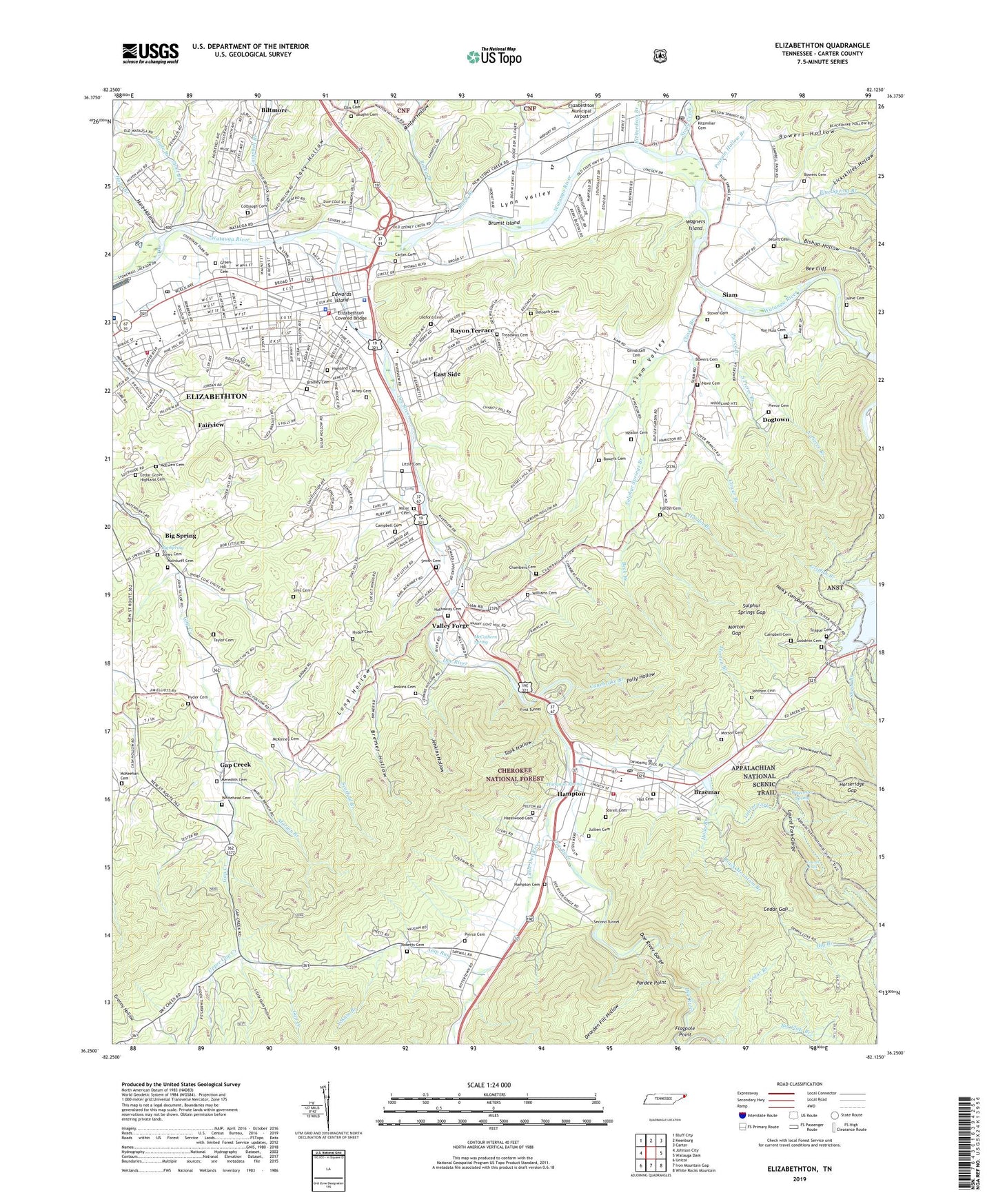
Elizabethton Tennessee US Topo Map
Couldn't load pickup availability
Also explore the Elizabethton Forest Service Topo of this same quad for updated USFS data
2022 topographic map quadrangle Elizabethton in the state of Tennessee. Scale: 1:24000. Based on the newly updated USGS 7.5' US Topo map series, this map is in the following counties: Carter. The map contains contour data, water features, and other items you are used to seeing on USGS maps, but also has updated roads and other features. This is the next generation of topographic maps. Printed on high-quality waterproof paper with UV fade-resistant inks.
Quads adjacent to this one:
West: Johnson City
Northwest: Bluff City
North: Keenburg
Northeast: Carter
East: Watauga Dam
Southeast: White Rocks Mountain
South: Iron Mountain Gap
Southwest: Unicoi
This map covers the same area as the classic USGS quad with code o36082c2.
Contains the following named places: Arney Cemetery, Beck Branch, Bee Cliff, Bemberg, Big Spring, Biltmore, Biltmore Census Designated Place, Biltmore Division, Bishop Hollow, Black Mountain, Black Mountain Branch, Blue Spring Branch, Bowers Cemetery, Bowers Hollow, Bradley Cemetery, Braemar, Bremer Hollow, Brumit Island, Bryant Ridge, Campbell Branch, Campbell Cemetery, Canebrake Branch, Carden Prospect, Carter Cemetery, Carter County, Carter County Landfill, Carter County Shopping Center, Carters Ironworks and Mill, Cat Island, Cedar Branch, Cedar Gap, Cedar Grove Highland Cemetery, Cedar Hill, Cedar Hill Mine, Cedar Mountain, Chambers Branch, Chambers Cemetery, Chambers Hollow, Charity Hill, Charity Hill School, Cherokee Industrial Park, City of Elizabethton, Civilian Conservation Corps Camp F1456, Clarks Mill, Clear Gap Shooting Range, Clover Branch, Colbaugh Cemetery, Commissioner District 4, Commissioner District 8, Davis Branch, Dearden Fill Hollow, Deloach Cemetery, Doe River, Doe River Gorge, Dogtown, Douglas School, Duffield Academy, Dugan Mill, East Side, East Side Elementary School, Eastern Tennessee State University Para-Medical Center, Edwards Island, Edward's Island Park, Elizabethton, Elizabethton City Park, Elizabethton Covered Bridge, Elizabethton Division, Elizabethton High School, Elizabethton Historic District, Elizabethton Municipal Airport, Ellis Branch, Emmerts Mill, Fairview, First Tunnel, Flagpole Point, Fork Mountain, Fork Mountain Prospect, Gap Creek, Gap Creek School, Gap Run, Goodwin Cemetery, Granny Hollow, Grays Branch, Green-Hill Cemetery, Griffith Branch, Grindstaff Cemetery, Grindstaff Prospect, Gum Hollow, Hall Cemetery, Hampton, Hampton Cemetery, Hampton Census Designated Place, Hampton Elementary School, Hampton High School, Hampton Spring, Hardin Branch, Hardin Cemetery, Hardin Prospect, Harold McCormick Elementary School, Harold Prospect, Hart Hollow, Hathaway Cemetery, Hazelwood Cemetery, Hazelwood Hollow, Heaton Cemetery, Highland Cemetery, Holly Branch, Horseridge Gap, Hunter, Hunter Elementary School, Hyder Cemetery, Hyder Prospects, Jenkins Cemetery, Jenkins Hollow, Jenkins Mine, Jenkins Mountain, Joe O'Brien Field, Johnson Cemetery, Jones Cemetery, Jullien Cemetery, Kitzmiller Cemetery, Lacy Hollow, Laurel Falls, Laurel Fork, Laurel Fork Gorge, Ledford Cemetery, Lewis - Pierce Cemetery, Lickskillet Hollow, Little Cemetery, Little Doe River, Little Gum Hollow, Little Mountain, Long Hollow, Loves Mill, Lynn Avenue Elementary School, Lynn Mountain, Lynn Valley, Marion Branch, McCathern Spring, McEwen Cemetery, McInturff Cemetery, McKeehan Cemetery, McKinney Cemetery, Meredith Cemetery, Miller Cemetery, Minton Hollow, Morton Branch, Morton Cemetery, Morton Gap, Nancy Campbell Hollow, Nave and Bowers Forge, Nave Cemetery, Nave Mine, North Pierce Branch, O'Briens and Gatts Forge, Pardee Point, Parkersons Fort, Peters Cemetery, Pierce Branch, Pierce Cemetery, Polk Ridge, Polly Hollow, Pond Branch, Possum Hollow, Possum Hollow Branch, Potato Top, Purlew Iron Works, Queen Station, Rayon Terrace, Rexford, Reynolds Branch, Rich Hollow Branch, Richardson Branch, Riverside Park, Roberts Cemetery, Rocky Branch, Saint Elizabeths School, Scaffold Branch, Second Tunnel, Shook Branch, Shook Branch Recreation Center, Siam, Siam Middle School, Siam Prospect, Siam Valley, Simmerlys Mill, Sims Cemetery, Slagle Branch, Smith Cemetery, Smiths Forge, Sorrell Cemetery, South Pierce Branch, Southside School, Stone Mountain Trail, Stony Creek, Stout Branch, Stover Cemetery, Sulphur Springs Branch, Sulphur Springs Gap, Sycamore Shoals Hospital, T A Dugger Junior High School, Talbots Mill, Tank Hollow, Taylor Cemetery, Teague Cemetery, Teaster and Ray Prospect, Tiptons Forge, Treadway Cemetery, Upper Gap Creek, Upper Gap Creek School, Valley Forge, Valley Forge Census Designated Place, Valley Forge Elementary School, Valley Forge Mine, Valley Park, Van Huss Cemetery, Vaughn Cemetery, Wagners Island, Walter Curtis Memorial Park, Watauga Area Mental Health Center, Watauga Lake Shelter, Watauga Old Fields, Watauga Work Center, Waycoster Spring, WBEJ-AM (Elizabethton), WDEJ, West Side Elementary School, West Towne Plaza Shopping Center, Whitehead Cemetery, WIDD-AM (Elizabethton), WIDD-FM (Elizabethton), Wilbur Dam, Williams Cemetery, Yokum Branch, Yokum Prospect