MyTopo
Jonesborough Tennessee US Topo Map
Couldn't load pickup availability
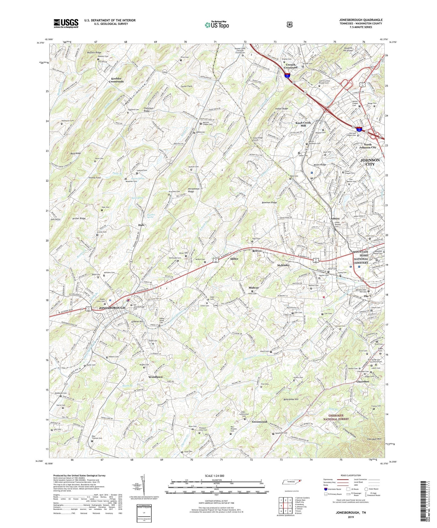
2019 topographic map quadrangle Jonesborough in the state of Tennessee. Scale: 1:24000. Based on the newly updated USGS 7.5' US Topo map series, this map is in the following counties: Washington. The map contains contour data, water features, and other items you are used to seeing on USGS maps, but also has updated roads and other features. This is the next generation of topographic maps. Printed on high-quality waterproof paper with UV fade-resistant inks.
Quads adjacent to this one:
West: Leesburg
Northwest: Sullivan Gardens
North: Boone Dam
Northeast: Bluff City
East: Johnson City
Southeast: Unicoi
South: Erwin
Southwest: Telford
Contains the following named places: Antioch Baptist Church, Arbor Heights, Archer Ridge, Asbury, Asbury Elementary School, Ashley Academy, Avondale Forest, Babbs - Smith Cemetery, Bald Knob, Bales Cemetery, Barkley Branch, Barnett - Tiner Hill Cemetery, Barton Cemetery, Bayless Cemetery, Beard Cemetery, Beech Spring, Beechwood Court, Belmont Acres, Berea School, Bernard School, Boone Trail, Boones Creek Christian Church Cemetery, Boones Creek Church, Boones Creek Elementary School, Bowman Ridge, Brentwood, Buffalo Ridge, Bugaboo Spring, Buncombe Hill, Camelot, Camelot Two, Carmel Village, Carmol, Carr - Reeves Cemetery, Carr Cemetery, Carr-Crumley-Krouse Cemetery, Carroll Reece Post Office, Carter Cemetery, Carter Crossing, Carter Sell, Center Field, Charbray, Cherokee, Cherokee Cemetery, Cherokee Church, Cherokee Elementary School, Cherokee Gardens, Cherokee Mountain, Chestnut Ridge, City of Johnson City, Clark Cemetery, Clark Manor, Colony Park, Columbia Institute, Commissioner District 3, Commissioner District 5, Commissioner District 6, Creassy Hollow, Creekside Shopping Center, Deacon Cemetery, District 15, Dove, Dove Cemetery, Draughons Junior College, Eden - Greenwood Cemetery, Elliott Cemetery, Estes Cemetery, February, Fine Cemetery, Forest Hills, Forest View, Foxxborough, France Cemetery, Glenwood Cemetery, Grand View School, Green Hill, Greenacres, Greene Hill, Greenfield Heights, Greenfields, Greenwood, Greenwood School, Haire Cemetery, Hale, Hale Cemetery, Hale School, Hardin Cemetery, Harris Cemetery, Harrison Chapel Cemetery, Highland Cemetery, Hilbert Cemetery, Hill-N-Dale, Holiday Shopping Center, Holmes, Holston Baptist Female Institute, Hunt Cemetery, Indian Ridge, Indian Ridge Fire Station, Indian Ridge Tunnel, Johnson City Division, Johnson City Fire Department Station 7, Johnson City Medical Center, Jones-Bayless Cemetery, Jonesborough, Jonesborough City Hall, Jonesborough Division, Jonesborough Elementary School, Jonesborough Fire Department, Jonesborough Middle School, Jonesborough Police Department, Jonesborough Post Office, Keebler Cemetery, Keebler Crossroads, Keefauver Cemetery, Kens Plaza Shopping Center, Knob Creek, Knob Creek Mill, Krouse Cemetery, Landmark Village Shopping Center, Leach Cemetery, Ledford Cemetery, Leonard Cemetery, Little Cemetery, Lyle Cemetery, Mahoney Hollow, Maison, Maison Institute, Maple Lawn Cemetery, Marvins Chapel Cemetery, Massengill Memorial, May-Peoples Cemetery, May-Thomas Cemetery, McAfee Stol Patch Airport, McKinley, McKinley Mobile Home Park, McKinley School, McNeil Cemetery, McNeil School, Melvin-Carathers Cemetery, Middleton Cemetery, Midway, Midway Census Designated Place, Midway Elementary School, Miller, Miller Cemetery, Miller Ridge, Miller Siding, Millercrest, Miracle Mall Shopping Center, Montclair, Mountain Home Cemetery, Mountain Home National Cemetery, Mountain Home Post Office, Nanatlugunyi, New Kiwanis Park, North Acres, North Hills, North Johnson City, North Knob Creek, Oak Hill School, Old Jonesborough Cemetery, Oliver Cemetery, Onks, Onks Cemetery, Open Door School, Paine Branch, Patton Chapel Cemetery, Peoples Cemetery, Peppermint Farms, Persimmon Ridge, Pine Timbers, Pleasant View Cemetery, Price Cemetery, Pritchett Cemetery, Ramblewood, Range Cemetery, Reed Cemetery, Reeves, Roadman Cemetery, Roundtree, Sandy Ridge Mobile Home Park, Scott Branch, Seminole Woods, Sequoyah Heights, Sherwood Forest, Shipley Cemetery, Skyline Heights, Slagle Cemetery, Snow Chapel, Snow Chapel Cemetery, South Gate, South Ridge Estates, Speedwell Cemetery, Spring City Mobile Home Park, Summit, Sunset Shopping Center, Susong Spring, Tamarack, Tamassee, Taylor Cemetery, The Y, Thomas Field, Timber Ridge, Timberlake, Town of Jonesborough, Towne Acres, Towne Acres Elementary School, Uriel Cemetery, Valley View School, Vaughn Cemetery, Vines Cemetery, Washington County, Washington County / Johnson City Emergency Medical Services, Washington County Courthouse, Washington County Farm, Washington County Sheriff's Office, Washington Heights, Wellington Park, West Hills, West Oakland Park, Westover, Westover Hills, WETB-AM (Johnson City), Williams Cemetery, Windmill Hill Airport, WJSO-AM (Jonesboro), Woodhill Addition, Woodlawn, Woodlawn School, Woodridge Hospital, Y Section, Young - Lyle - Strickland Cemetery, Young Cemetery, ZIP Codes: 37604, 37659