MyTopo
Lincoln Tennessee US Topo Map
Couldn't load pickup availability
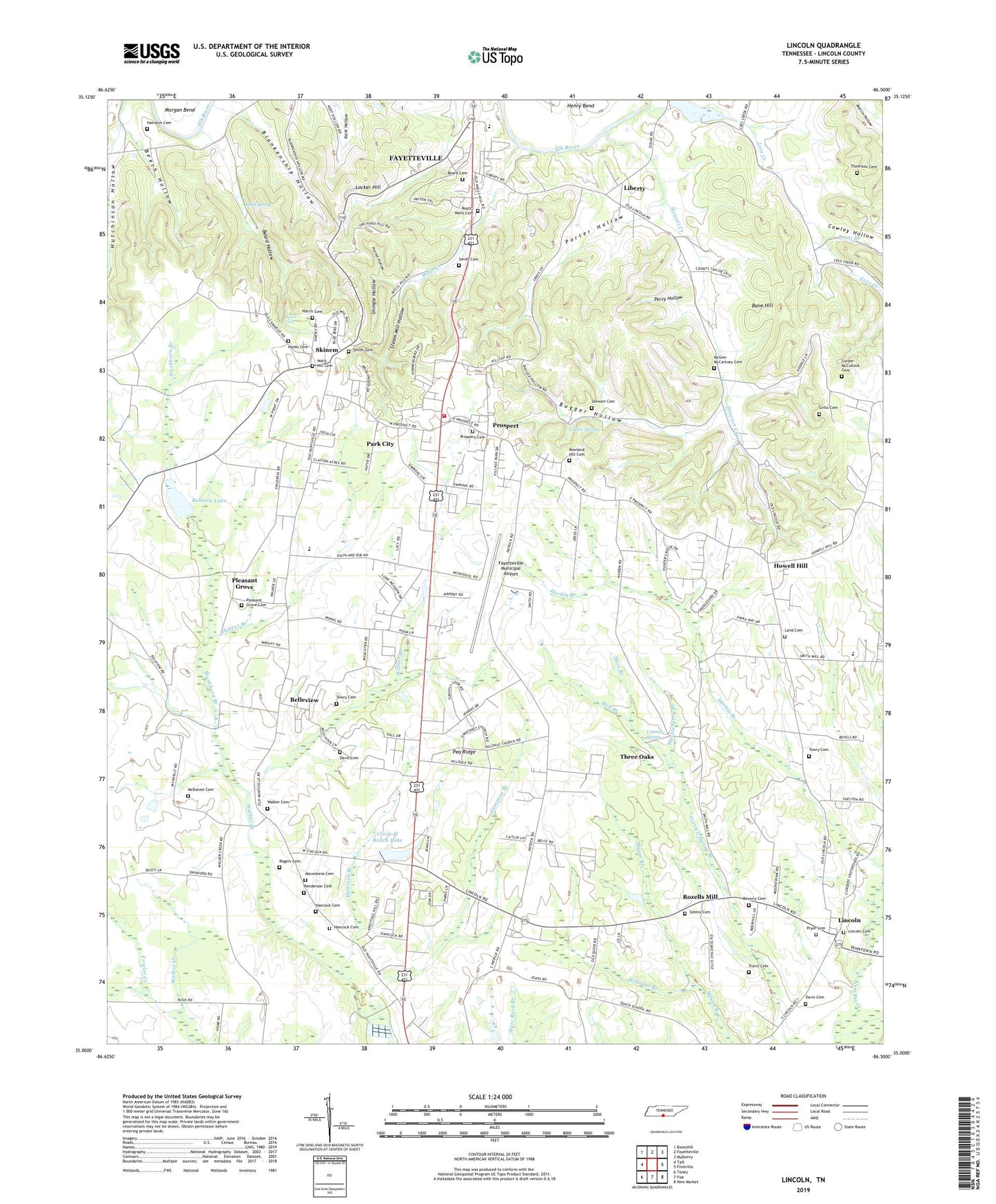
2022 topographic map quadrangle Lincoln in the state of Tennessee. Scale: 1:24000. Based on the newly updated USGS 7.5' US Topo map series, this map is in the following counties: Lincoln. The map contains contour data, water features, and other items you are used to seeing on USGS maps, but also has updated roads and other features. This is the next generation of topographic maps. Printed on high-quality waterproof paper with UV fade-resistant inks.
Quads adjacent to this one:
West: Taft
Northwest: Boonshill
North: Fayetteville
Northeast: Mulberry
East: Flintville
Southeast: New Market
South: Fisk
Southwest: Toney
This map covers the same area as the classic USGS quad with code o35086a5.
Contains the following named places: Bane Hill, Beard Cemetery, Beard Hollow, Beech Hollow, Belleview, Belleview Division, Bellview School, Beverly Cemetery, Blankenship Hollow, Boone Falls, Bugger Hollow, Camp Dunroamin, Campers Branch, Chapman Farm, Childress Lake Dam, Circle H Ranch Lake, Commissioner District 3, Commissioner District 4, Commissioner District 5, Commissioner District 8, Concord Church, Corder-McCullock Cemetery, Cottrell Spring, Cowley Hollow, Davis Cemetery, Duncan Farms, Dunns Store, Eastwood Estates, Fayetteville Municipal Airport, Fayetteville Pumping Station, Goshen, Greenwood Estates, Grills Cemetery, Hairston Cemetery, Hancock Branch, Hancock Cemetery, Hanks Cemetery, Harper Branch, Harris Cemetery, Henderson Cemetery, Henry Bend, Highland Rim, Highland Rim Elementary School, Hilldale Estates, Hog Branch, Hornet Hollow, Howell Hill, Howell Hill Baptist Church, Howell Hill School, Huckleberry Branch, Hutchinson Hollow, Johnson School, Keith Spring, Lamarsons Plantation, Land Cemetery, Lees Creek, Liberty, Liberty School, Lincoln, Lincoln Baptist Church, Lincoln Cemetery, Lincoln School, Locker Hill, Locker Spring, Macedonia Cemetery, Macedonia Church, McAlister Farms, McDaniel Cemetery, McGee-McCartney Cemetery, Mire Branch, Oakwood Acres Lake, Park City, Park City Census Designated Place, Park City Heights, Park City Shopping Center, Park City Volunteer Fire Rescue, Parks City Baptist Church, Pea Ridge, Percy Hollow, Plada Heights, Pleasant Grove, Pleasant Grove Cemetery, Pleasant Grove Church, Porter Hollow, Prospect, Prospect Baptist Church, Prospect Cemetery, Prospect School, Pryor Cemetery, Quick School, Rambo Lake Dam, Rebecca Lake, Rebecca Lake Dam, Rogers Cemetery, Roland Hill Church, Rolling Hills, Routt - Wells Cemetery, Routt Branch, Rowland Hill Cemetery, Rozells Mill, Shingle Hollow, Simms Cemetery, Skinem, Smith Cemetery, Steam Mill Hollow, Stewart Cemetery, Stewart Creek, Stonecreek Farm, Thomison Cemetery, Three Oaks, Towry Cemetery, Travis Cemetery, Triple Bar Ranch, Triple T Dairy, Walker Branch, Walker Cemetery, Washburn Branch, Wells Creek, Wells Hill, Wells Hill Cemetery, Westbrook, Williams Branch