MyTopo
Ooltewah Tennessee US Topo Map
Couldn't load pickup availability
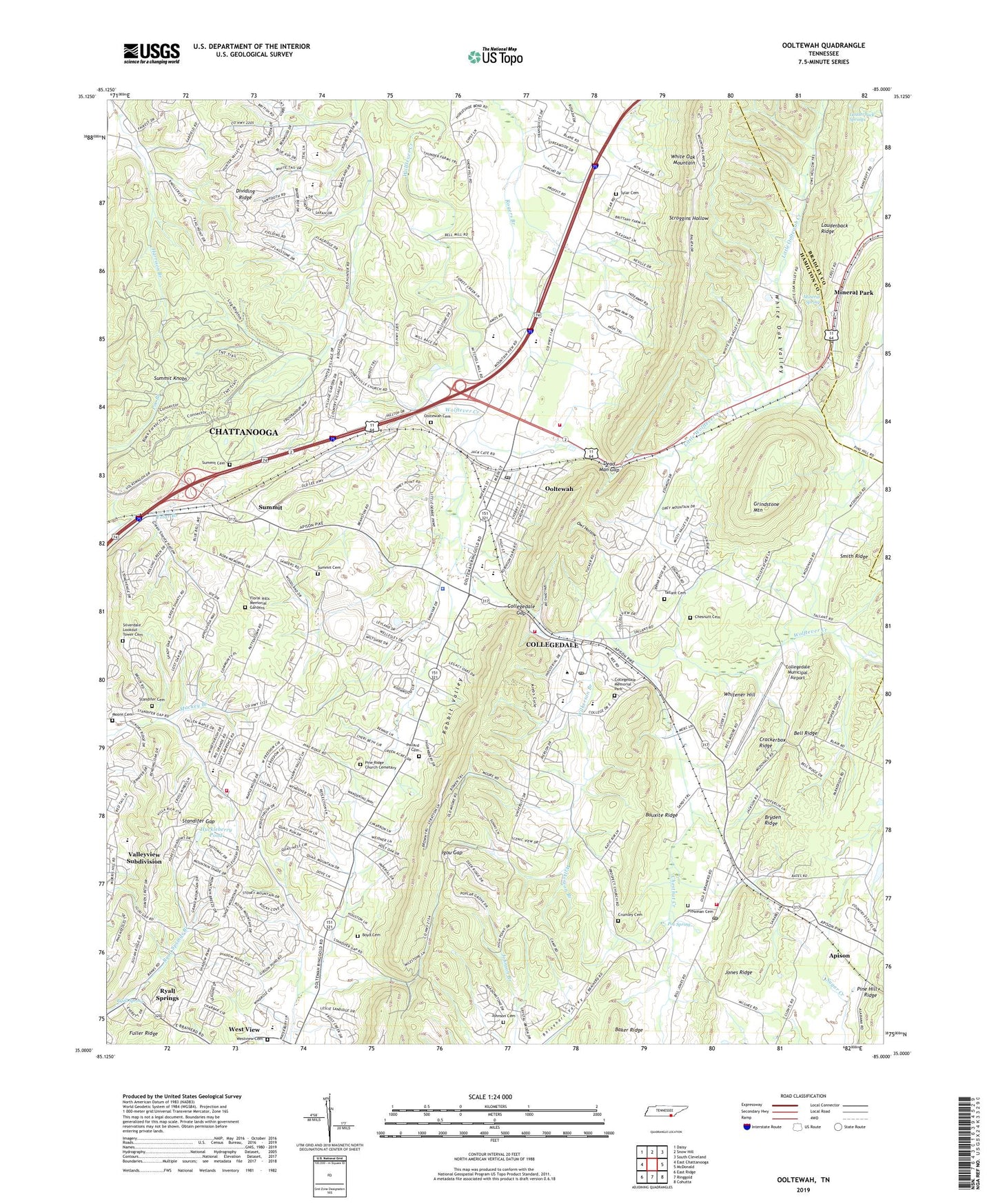
2019 topographic map quadrangle Ooltewah in the state of Tennessee. Scale: 1:24000. Based on the newly updated USGS 7.5' US Topo map series, this map is in the following counties: Hamilton, Bradley. The map contains contour data, water features, and other items you are used to seeing on USGS maps, but also has updated roads and other features. This is the next generation of topographic maps. Printed on high-quality waterproof paper with UV fade-resistant inks.
Quads adjacent to this one:
West: East Chattanooga
Northwest: Daisy
North: Snow Hill
Northeast: South Cleveland
East: McDonald
Southeast: Cohutta
South: Ringgold
Southwest: East Ridge
Contains the following named places: Adventist Church, Apison, Apison Census Designated Place, Apison Church, Apison Elementary School, Apison Post Office, Arthur W Spalding School, Auburn Hills, Bauxite Ridge, Bayside Baptist Church, Bell Mill, Bell Ridge, Boyd Cemetery, Bryden Ridge, Chesnutt Cemetery, Chestnut Creek, City of Collegedale, College Plaze Shopping Center, Collegedale, Collegedale Gap, Collegedale Memorial Park, Collegedale Municipal Airport, Collegedale Police Department, Collegedale Post Office, Commissioner District 7, Crackerbox Ridge, Crumley Cemetery, Dead Man Gap, Dividing Ridge, East Brainerd Census Designated Place, Fairview Church, Floral Hills Memorial Gardens, Fourth District School, Friendship Church, Fuller Ridge, Green Acres, Green Shanty Hollow, Grindstone Estates, Grindstone Mountain, High Point Church, Hill Top Church, Holy Bible Church, Honestville Church, Huckleberry Pond, Igou Gap, James County, Johnson Cemetery, Jones Ridge, Lauderback Springs, Little Ooltewah Creek, Little Wolftever Creek, Maplewood Heights, Middle School, Mineral Park, Mineral Park Chapel, Mineral Spring, Moore Cemetery, New Salem Church, Ooltewah, Ooltewah Cemetery, Ooltewah Census Designated Place, Ooltewah Church, Ooltewah Division, Ooltewah Elementary School, Ooltewah High School, Ooltewah Middle School, Ooltewah Post Office, Owl Hollow, Paradise Mobile Home Park, Parkridge Valley Hospital, Pine Ridge Church, Pine Ridge Church Cemetary, Plowman Cemetery, Poe Spring, Pollard Cemetery, Ponderosa Pines, Primitive Church, Robinson Corner Shopping Center, Ryall Spring, Ryall Springs, Saint Peter Church, Salem Church, Scroggins Hollow, Silverdale Lookout Tower Cemetery, Smith Prospect, Southern Missionary College, Standifer Cemetery, Standifer Gap, Standifer Gap Church, Summit, Summit Cemetery, Summit Knobs, Summit School, Swishers Chapel, Sylar Cemetery, Tall Oaks Mobile Home Park, Tallant Cemetery, Tallant Church, Tri - Community Volunteer Fire Department Station 1 - Collegedale, Tri - Community Volunteer Fire Department Station 3 - Apison, Tri - Community Volunteer Fire Department Station 4, Tri - Community Volunteer Fire Department Station 5, Valleyview Subdivision, Wells, West View, West View Cumberland Presbyterian Church, Westview Cemetery, Westview Elementary School, White Oak Mountain, White Oak Valley, Whitener Hill, Wilkerson Branch, Williamsburg Estates, Willie Moore Prospect, WSMC-FM (Collegedale), Yorktown Woods, ZIP Codes: 37302, 37315, 37363