MyTopo
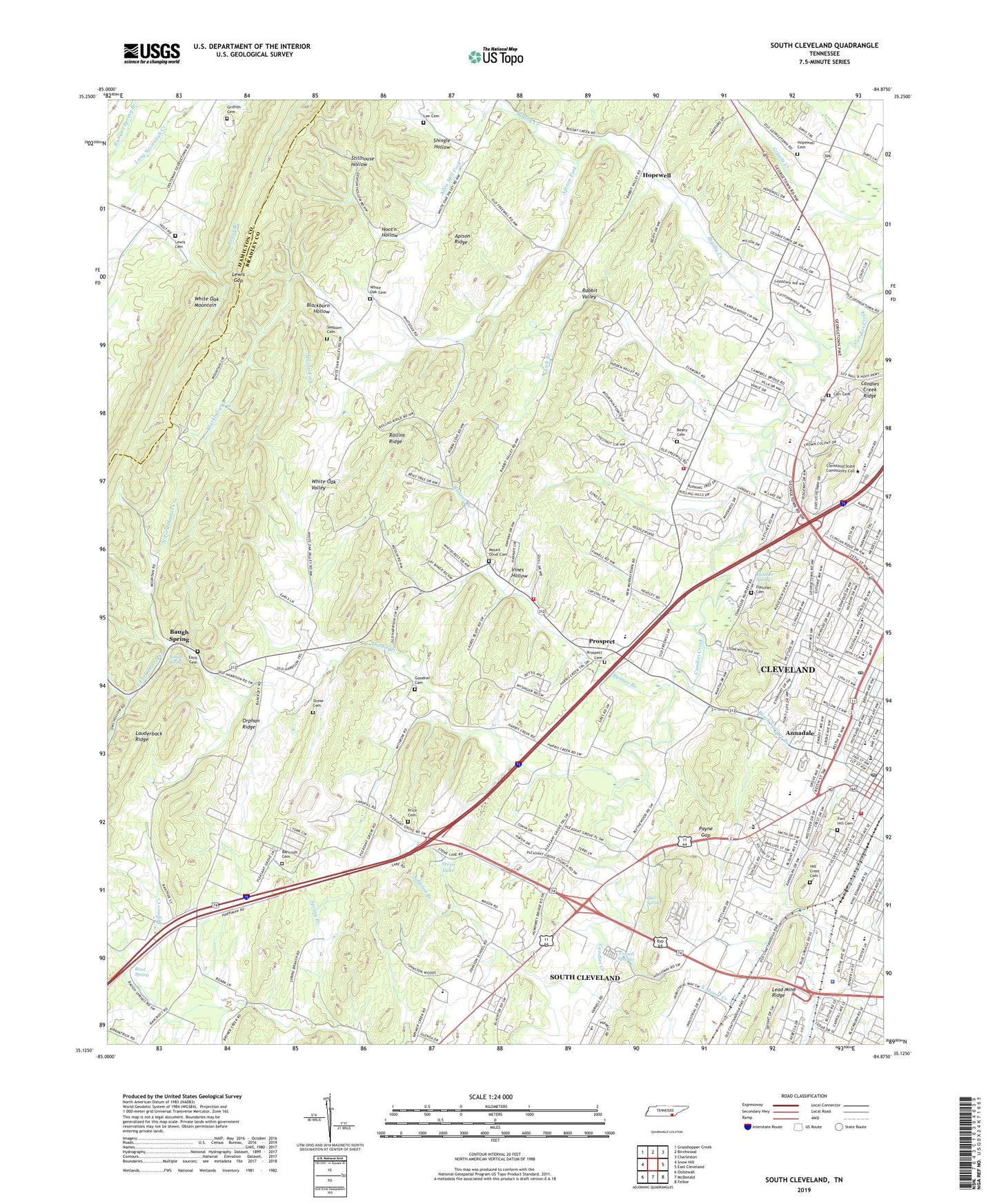
South Cleveland Tennessee US Topo Map
Couldn't load pickup availability
2022 topographic map quadrangle South Cleveland in the state of Tennessee. Scale: 1:24000. Based on the newly updated USGS 7.5' US Topo map series, this map is in the following counties: Bradley, Hamilton. The map contains contour data, water features, and other items you are used to seeing on USGS maps, but also has updated roads and other features. This is the next generation of topographic maps. Printed on high-quality waterproof paper with UV fade-resistant inks.
Quads adjacent to this one:
West: Snow Hill
Northwest: Grasshopper Creek
North: Birchwood
Northeast: Charleston
East: East Cleveland
Southeast: Felker
South: McDonald
Southwest: Ooltewah
This map covers the same area as the classic USGS quad with code o35084b8.
Contains the following named places: Allen Mill Fork, Annadale, Apison Fork, Apison Ridge, Appalachian Industrial Park, Arnold Memorial High School, Bachman Memorial Childrens Home, Bancroft Cemetery, Bancroft Church, Baugh Spring, Beaty Cemetery, Beech Springs Branch, Bent Tree Acres, Bigsby Creek, Bigsby Creek Estates, Black Fox Elementary School, Blackburn Creek, Blackburn Hollow, Blythewood Stock Farms, Bradley County Courthouse, Bradley County Fire and Rescue Station 5 - Prospect, Bradley County High School, Bradley County Sheriff's Department, Brentwood Estates, Broad Street United Methodist Church, Bulldog Branch, Calvary Baptist Church, Candies Creek Ridge, Carr Cemetery, Cleveland, Cleveland Community Hospital, Cleveland Fire Department Station 1, Cleveland Fire Department Station 5, Cleveland Post Office, Cleveland State Community College, Cleveland-Bradley County Industrial Park, Clingan Ridge Church, Commissioner District 1, Commissioner District 5, Commissioner District 7, Countryside Village, Davis Heights, Downtown Cleveland Post Office, Earls Cemetery, Elkmont Baptist Church, Eureka Hills, Fletcher Cemetery, Fletcher Spring, Fort Hill Cemetery, Freewill, Freewill Baptist Church, Galilee Baptist Church, George R Stuart Elementary School, Goodner Cemetery, Grace Church, Griffith Cemetery, Hall Spring, Harris Creek, Hidden Valley, Hillcrest Memorial Gardens, Hills and Dales, Hoot'n Hollow, Hope Acres, Hopewell, Hopewell Baptist Church, Hopewell Cemetery, Hopewell Census Designated Place, Hopewell Church, Hopewell Elementary School, Hopewell Estates, Johnson Branch, Johnson School, Johnston Campside, Johnston Park, King Mine, King Prospect, Laurel Ridge, Laurel Springs, Laurel Valley, Lee Cemetery, Lee Estates, Leggs Mill, Lewis Cemetery, Lewis Gap, Lick Branch, Meadowview, Meadowview Mission, Missionary Church, Moore School, Mount Olive Cemetery, Mount Olive Church, Mountainbrook, New Prospect Church, New Salem Church, Norman Chapel School, North Fork Harris Creek, Northwest Acres, Orphan Ridge, Overbrook, Payne Gap, Pentecostal Orphanage, Phillippi Baptist Church, Pleasant Grove Church, Polk-Bradley Vocational Training Center, Price Cemetery, Prospect, Prospect Cemetery, Prospect Elementary School, Rabbit Valley, Reed Spring, Ridgeview Baptist Church, Ridgewood, Rolling Hills, Rolling Hills Golf Club, Rollins Ridge, Runner Branch, Saint Lukes Episcopal Church, Seaborn Cemetery, Shiloh Church, Shingle Hollow, South Cleveland Church of God, South Cleveland Community Center, South Fork Harris Creek, South Rolling Hills, Spring Branch, Stillhouse Hollow, Stone Cemetery, Stone Lake, Stuart Park Baptist Church, Temple Baptist Church, Thomas C Bower Elementary School, Varnell Estates, Varnell Springs, Victory Church, Villa Heights, Village Mall Shopping Center, Vines Hollow, West Bradley Division, Westview Heights, Westwood Baptist Church, White Oak Baptist Church, White Oak Cemetery, White Oak Valley, Whiteoak School, ZIP Code: 37312