MyTopo
Pioneer Tennessee US Topo Map
Couldn't load pickup availability
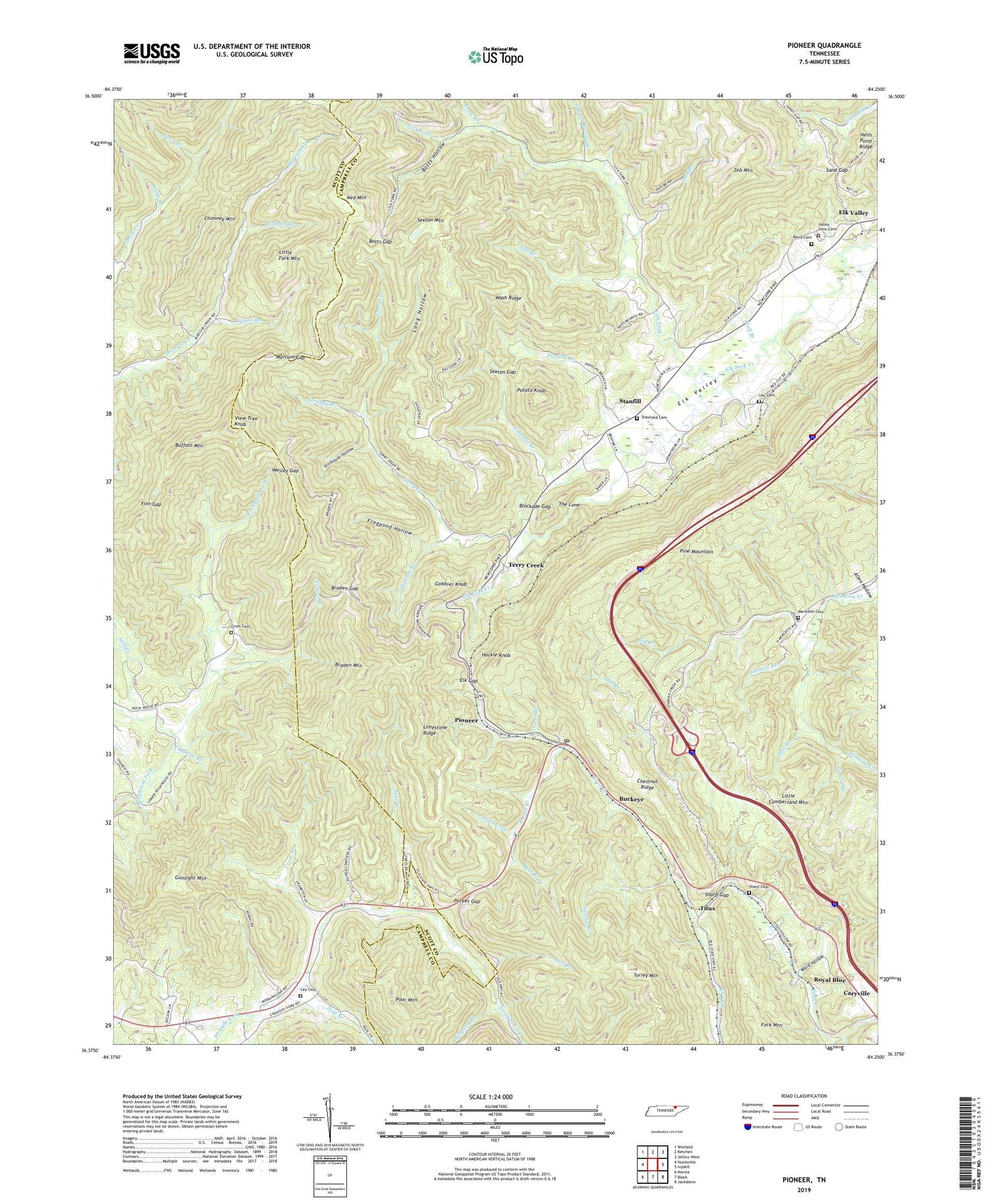
2019 topographic map quadrangle Pioneer in the state of Tennessee. Scale: 1:24000. Based on the newly updated USGS 7.5' US Topo map series, this map is in the following counties: Campbell, Scott. The map contains contour data, water features, and other items you are used to seeing on USGS maps, but also has updated roads and other features. This is the next generation of topographic maps. Printed on high-quality waterproof paper with UV fade-resistant inks.
Quads adjacent to this one:
West: Huntsville
Northwest: Winfield
North: Ketchen
Northeast: Jellico West
East: Ivydell
Southeast: Jacksboro
South: Block
Southwest: Norma
Contains the following named places: Allen Hollow, Baird Cemetery, Bear Branch, Big Branch, Blockade Gap, Botts Gap, Botts Hollow, Braden Gap, Braden Mountain, Buckeye, Buffalo Mountain, Chestnut Ridge, Collins Branch, Coontail Branch, Crabtree Branch, Cross Branch, Cross Cemetery, Dan Branch, Douglas Branch, Drew Branch, Elk Fork Baptist Church, Elk Gap, Elk Valley Elementary School, Emmanuel Baptist Church, Finn Gap, Frogpond Hollow, Gobbler Knob, Granny Barnes Branch, Graves Branch, Gunsight Mountain, Hackle Knob, Hudson Branch, Jake Branch, Jakes Branch Church, Johnson Branch, Lay Cemetery, Lick Branch, Lick Fork, Lick Fork School, Limestone Ridge, Little Fork Mountain, Long Hollow, Lost Branch, Marcum Gap, Meredith Cemetery, Mill Branch, Mooney Mine, Neal Branch, Ned Branch, Ned Mountain, New Canaan United Baptist Church, Phillips Red Ash Mine, Pioneer, Pioneer First Baptist Church, Pioneer Post Office, Pioneer School, Poor Mountain, Potato Knob, Poteet Gap, Rector Branch, Rockhouse School, Royal Blue, Royal Blue School, Royal Blue Wildlife Management Area, Sand Gap, Scruggs Branch, Sexton Gap, Sexton Mountain, Sharp Cemetery, Sharp Gap, Shelton Branch, Simpson Branch, Smith Cove, Stanfield Cemetery, Stanfield United Baptist Church, Stanfill, Stanfill School, Stell Branch, Still Creek, Stillhouse Hollow, Straight Fork, Straight Fork School, Swamp Branch, Terry Branch, Terry Creek, Terry Creek School, The Lone, Titus, Titus Creek, Turley Mountain, Valley View Cemetery, View Tree Knob, Ward Hollow, Wash Ridge, Webb Branch, Wesley Gap, Wilson Branch, Wolf Branch, Wolfpen Branch, Zeb Mountain, ZIP Code: 37847