MyTopo
Block Tennessee US Topo Map
Couldn't load pickup availability
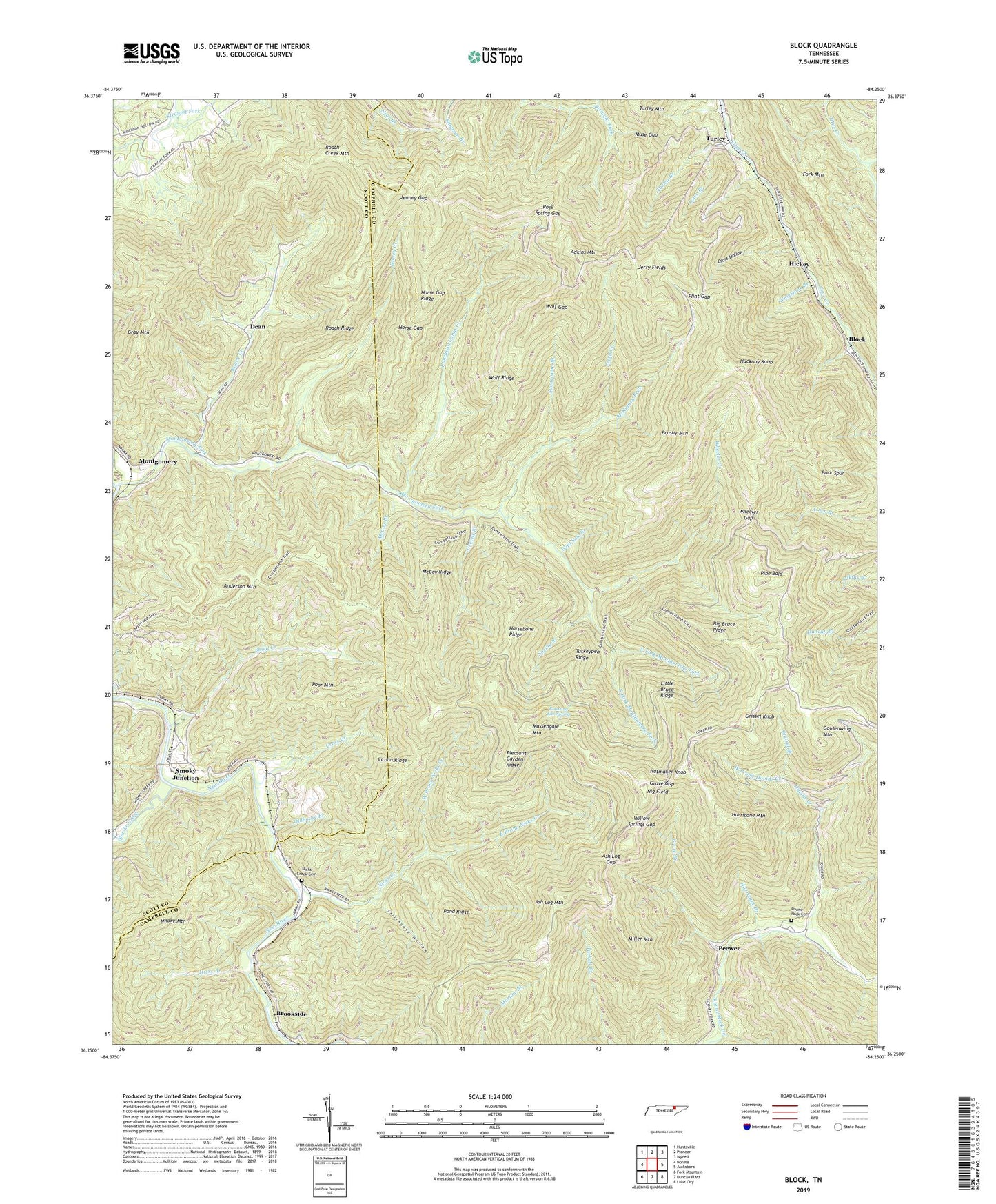
2022 topographic map quadrangle Block in the state of Tennessee. Scale: 1:24000. Based on the newly updated USGS 7.5' US Topo map series, this map is in the following counties: Campbell, Scott. The map contains contour data, water features, and other items you are used to seeing on USGS maps, but also has updated roads and other features. This is the next generation of topographic maps. Printed on high-quality waterproof paper with UV fade-resistant inks.
Quads adjacent to this one:
West: Norma
Northwest: Huntsville
North: Pioneer
Northeast: Ivydell
East: Jacksboro
Southeast: Lake City
South: Duncan Flats
Southwest: Fork Mountain
This map covers the same area as the classic USGS quad with code o36084c3.
Contains the following named places: Adkins Mountain, Anderson Mountain, Antioch Baptist Church, Ash Log Gap, Ash Log Mountain, Back Spur, Big Bruce Ridge, Block, Block School, Brookside, Brushy Mountain, Clinchmore Division, Commissioner District 4, Cross Creek, Cross Hollow, Davids Creek, Dean, Dean Mine, Dean School, Delmont Mine, Diamond Number Seven Mine, Diamond Number Three Mine, East Prong Nicks Creek, Flint Gap, Goldenwing Mountain, Grave Branch, Grave Gap, Gray Mountain, Greens Branch, Grissel Branch, Grissel Knob, Hatmaker Knob, Hickey, Hicks Branch, High Point Number One Mine, High Point Number Two Mine, Horse Gap, Horse Gap Ridge, Horsebone Ridge, Huckaby Knob, Hurricane Branch, Hurricane Mountain, Hurricane Mountain Mines, Jenney Creek, Jenney Gap, Jerry Creek, Jerry Fields, Jordan Number Four Mine, Jordan Ridge, Little Bruce Ridge, Lowe Branch, Martin Mine, Massengale Mountain, McCoy Branch, McCoy Ridge, McKinney Fork, Miller Mountain, Monarch Mine, Montgomery, Montgomery Fork, Muse Gap, New Laxton Mine, Nicks Creek, Nicks Creek Baptist Church, Nicks Creek Cemetery, Nig Field, North Fork Montgomery Fork, Oldhouse Branch, Peewee, Pewee Mines, Pine Bald, Pleasant Garden Ridge, Pond Ridge, Poor Mountain, Puncheon Camp Creek, Red Ash Mines, Roach Creek, Roach Creek Mountain, Roach Ridge, Roasting Ear Spring, Rock Spring Gap, Round Rock, Round Rock Baptist Church, Round Rock Cemetery, Round Rock School, Shoal Creek, Smoky Creek, Smoky Junction, South Fork Montgomery Fork, Spring Branch, Stillhouse Hollow, Stoney Fork Volunteer Fire Department, Straight Fork Mine, Sugarcamp Branch, Turkeypen Ridge, Turley, Turley Branch, Turley Mine, Turley Petree Mine, Turley School, Upper Round Rock School, West Prong Davids Creek, West Prong Nicks Creek, Wheeler Creek, Wheeler Gap, Whetstone Branch, Wild Sow Branch, Willow Springs Gap, Wolf Gap, Wolf Ridge, ZIP Code: 37714