MyTopo
Scottsboro Tennessee US Topo Map
Couldn't load pickup availability
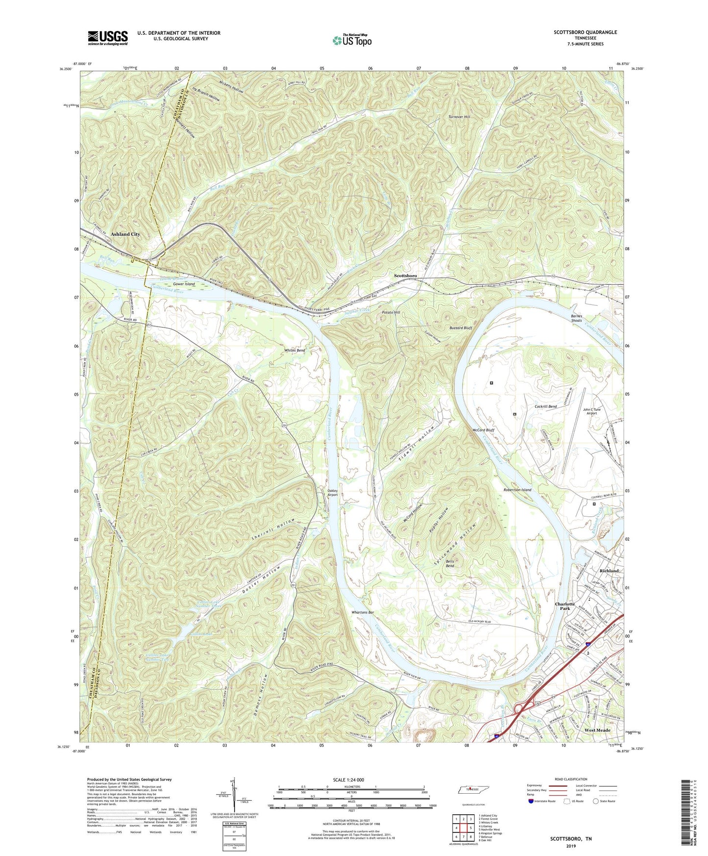
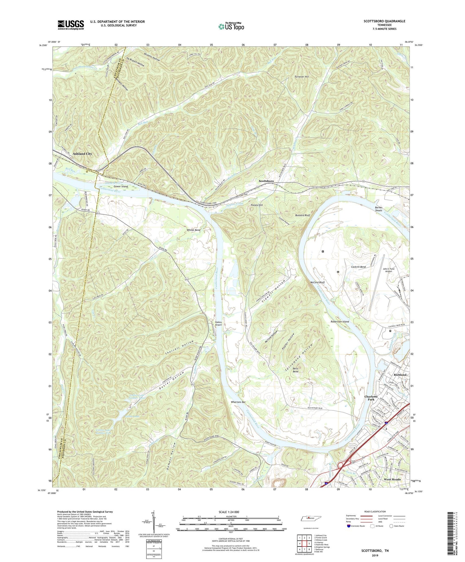
2019 topographic map quadrangle Scottsboro in the state of Tennessee. Scale: 1:24000. Based on the newly updated USGS 7.5' US Topo map series, this map is in the following counties: Davidson, Cheatham. The map contains contour data, water features, and other items you are used to seeing on USGS maps, but also has updated roads and other features. This is the next generation of topographic maps. Printed on high-quality waterproof paper with UV fade-resistant inks.
Quads adjacent to this one:
West: Lillamay
Northwest: Ashland City
North: Forest Grove
Northeast: Whites Creek
East: Nashville West
Southeast: Oak Hill
South: Bellevue
Southwest: Kingston Springs
Contains the following named places: Back Creek, Barnes Shoals, Bells Bend, Bennett Hollow, Bloomsteins Landing, Brookmeade Church, Brookmeade Elementary School, Buchanan School, Bull Run, Bull Run Recreation Area, Bull Run Road Church, Buzzard Bluff, Camp Dogwood, Centenary Church, Charles B Bass Correctional Complex, Charlotte Center Shopping Center, Charlotte Park, Charlotte Park School, Charlotte Square Shopping Center, Christ Community Church, Cleeces Ferry, Cochrans Mill, Cockrill Bend, Collins Lake, Collins Lake Dam Number One, Collins Lake Dam Number Three, Collins Lake Dam Number Two, Collins Lake Number One, Collins Lake Number Three, Collins Lake Number Two, Commissioner District 20, Commodore Yacht Club, Cub Creek, Cub Creek School, Cullom Hollow, Davidson Branch, Davidsons Landing, Demoss Hollow, Dozier Hollow, Dozier Landing, Doziers, Ewin Branch, Gower Island, Hickman Ferry, Hill Park, Hillwood Plaza Shopping Center, Horton Heights Church, Immanuel Church of the Nazarene, Indian Creek, Indian Creek Boat Ramp, Island Branch, Ivy Branch Hollow, James Avenue Church of Christ, John C Tune Airport, Lois M DeBerry Special Needs Facility, Long Branch, McCord Bluff, McCord Hollow, New Bethel Church, New Hope Baptist Church, New Hope Church, New Hope School, Nickens Hollow, Oakley Airport, Overall Creek, Pond Creek, Pond Creek Church, Pond Creek Ferry, Pond Creek Landing, Pond Creek School, Poplar Hollow, Potato Hill, Religious Science Church of Nashville, Richland Creek, Richland Freewill Baptist Church, River Bend Church, Riverbend Maximum Security Institution, Robertson Island, Robertsons Landing, Rock Harbor Marina, Sandy Creek, Scottsboro, Scottsboro Church of Christ, Scottsboro First Baptist Church, Scottsboro Mission, Scottsboro United Methodist Church, Seats Landing, Sherrell Hollow, Spicewood Hollow, Stateland Baptist Church, Strickland School, Sulphur Creek, Tidwell Hollow, Timmons Landing, Turnover Hill, Wade School, Watkins, Watkins Chapel, Watkins Landing, West Fork Pond Creek, West Nashville Cumberland Presbyterian Church, Whartons Bar, Whites Bend, WLUY-AM (Nashville), ZIP Codes: 37209, 37218