
MyTopo
Springvale Tennessee US Topo Map
Couldn't load pickup availability
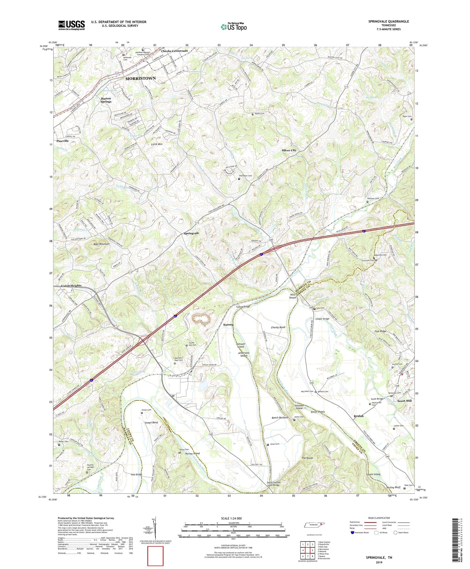
2019 topographic map quadrangle Springvale in the state of Tennessee. Scale: 1:24000. Based on the newly updated USGS 7.5' US Topo map series, this map is in the following counties: Hamblen, Greene, Cocke. The map contains contour data, water features, and other items you are used to seeing on USGS maps, but also has updated roads and other features. This is the next generation of topographic maps. Printed on high-quality waterproof paper with UV fade-resistant inks.
Quads adjacent to this one:
West: Morristown
Northwest: Bean Station
North: Russellville
Northeast: Bulls Gap
East: Mohawk
Southeast: Parrottsville
South: Rankin
Southwest: White Pine
Contains the following named places: Andersons Shoals, Bailey Branch, Barton Spring, Barton Springs, Beech Bottoms, Belair, Bent Creek, Bethel Baptist Church, Bethesda Cemetery, Bethesda Church, Beulah, Beulah Chapel School, Beulah Church, Big Spring, Big Spring Branch, Brockland Acres, Bush Brothers Strip Airport, Cane Ford, Catherine Nenny Church, Cedar Grove Church, Cedar Grove School, Chuckey Bend, Chucky Bend, Commissioner District 10, Commissioner District 8, Cooper Branch, Cooper Bridge, Cooper Landing Strip, Cooper Spring, Courtney Cemetery, Creek Store, David Thomas Jones Bridge, Dover, Dover Church, Dry Branch, East Ridge Middle School, East Village, Enka Dam, Enterprise Church, Enterprise School, Faith Mission, Flat Creek, Flea Ridge, Forest Hill Cemetery, Frank Lorino Park, Fuller Estates, Glendale, Glendale Church, Glendale School, Hale Branch, Hale Bridge, Hale Cemetery, Hamblen Memory Gardens Cemetery, Haun Cemetery, Heath Cemetery, Hills Shoals, Holloway School, Hurley Acres, Hurley Cemetery, Hurley Island, Inman, Inman Bend, Inman Cemetery, Inman Ford, Iron Spring, Johnson Island, Jones Cemetery, Jones School, Kesterson Cemetery, Kingswood, Kirk Chapel, Kneelas Creek, Lampkin Acres, Lick Creek, Little Bent Creek, Little Mountain, Little Pineville Church, Long Creek, Lowland, Lowland Post Office, Lowland School, Luster Cemetery, Lyle Cemetery, Marshall Creek, Matthews Gap, McCorkel Cemetery, McDonald Volunteer Fire Department, McKenney Cemetery, Miller W Boyd School, Morristown State Fish Hatchery, Moser Cemetery, Mount Airy Church, Mount Airy Springs, Mount Moriah Church, Neilson Cemetery, Nenny, Old Saint Paul Cemetery, Pineville, Red Run, Robinson Creek, Rocky Point, Rocky Point Church, Saint Paul Church, Scoot Bridge, Scoot Mill, Sherwood Estates, Silver City, Silver City Branch, Skulley Bluff, Slate Creek, Slop Branch, Smith Shoals, Solid Rock Church, Solomon Island, Springvale, Steele Island, Susong, Susong Bridge, Talley Cemetery, Thomas Jarnagin Cemetery, Thomason Cemetery, Toneys Chapel, Turkey Creek, Union Grove Church, Union Heights, Union Heights Elementary School, Whites Little Mountain Orchard, Williams Cemetery, Willow Creek, Windvue Estates, Wisecarver Cemetery, Wolf Acres


