MyTopo
Russellville Tennessee US Topo Map
Couldn't load pickup availability
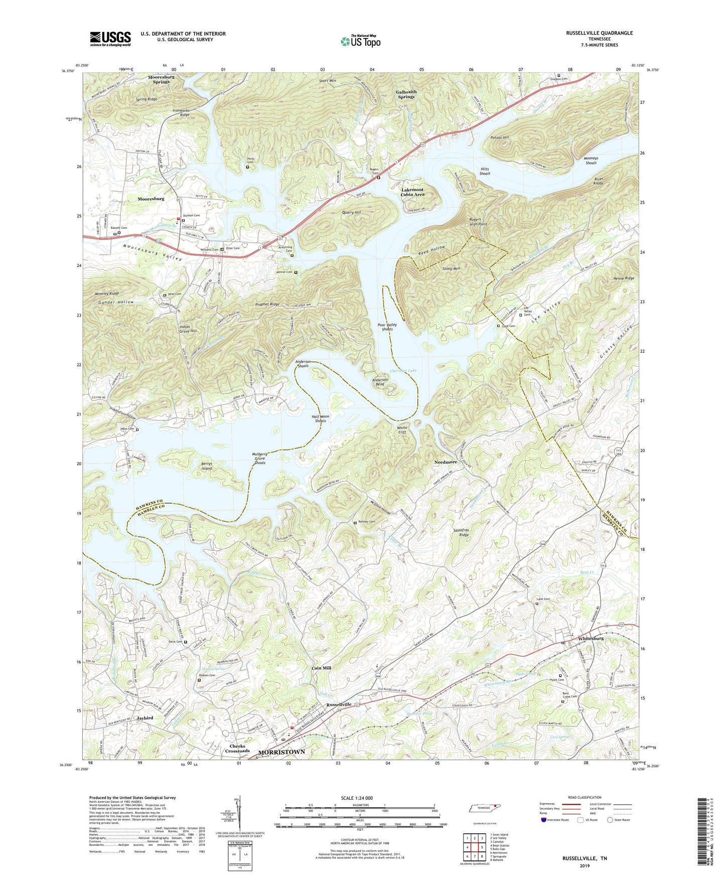
2022 topographic map quadrangle Russellville in the state of Tennessee. Scale: 1:24000. Based on the newly updated USGS 7.5' US Topo map series, this map is in the following counties: Hawkins, Hamblen. The map contains contour data, water features, and other items you are used to seeing on USGS maps, but also has updated roads and other features. This is the next generation of topographic maps. Printed on high-quality waterproof paper with UV fade-resistant inks.
Quads adjacent to this one:
West: Bean Station
Northwest: Swan Island
North: Lee Valley
Northeast: Camelot
East: Bulls Gap
Southeast: Mohawk
South: Springvale
Southwest: Morristown
This map covers the same area as the classic USGS quad with code o36083c2.
Contains the following named places: Amy Island, Anderson Bend, Anderson Shoals, Armstrong Cemetery, Bassett Cemetery, Bent Creek Cemetery, Berry Island, Berrys Island, Berrys Island Ecological Study Area, Bingham Branch, Bingham Island, Bright, Bright Ferry, Cain Mill, Cardinal Hills, Cave Spring, Cedar Creek, Cedar Creek Church, Cheeks Crossroads, Cherokee Dock, Cherokee Lake Campground, Clinchview Heights, Cobb Cemetery, Cobb Ford, Cobb Island, Commissioner District 9, Creech Chapel, Davis Cemetery, Dean Cemetery, Dickenson Pond, Dickson Cemetery, Dodson Cemetery, Dodson Spring, Dougherty Quarry, Dry Branch, East Hamblen County Volunteer Fire Department, East Manor, Ervin Chapel, Etter Cemetery, Evans Quarry, Fairfield Acres, Fairfield Church, Fall Creek, Fall Creek Campground, Fudge Quarry, Galbraith, Galbraith Branch, Galbraith Church, Galbraith School, Galbraith Springs, Gander Hollow, Gladson Cemetery, Glendale Acres, Grassy Valley, Half Moon Shoals, Hicks Cemetery, Hilts Shoals, Holston Hills, Hubert Chapel, Hyatt Acres, Hyatt Cemetery, Hyatt Spring, Indian Grave Hill, Ironworks Ridge, Jaybird, Jesus Church, Jimtown Hollow, Kellar Branch, Kenner Cemetery, Kenners Island, Kentucky Heights, Lakemont Cabin Area, Lakeshore Estates, Lakeview Volunteer Fire Department Station 2, Lane Cemetery, Lee Valley, Lee Valley Cemetery, Lee Valley Church, Lee Valley School, Mays Cemetery, McClure Quarry, McGhee Hollow, Mooneys Shoals, Moore Branch, Mooresburg, Mooresburg Branch, Mooresburg Census Designated Place, Mooresburg Division, Mooresburg Elementary School, Mooresburg Post Office, Mooresburg School, Mooresburg Springs, Mulberry Grove Shoals, Music Acres, Nalls Ford, Needmore, Needmore Creek, Nenny Ridge, Poor Valley Creek, Poor Valley Shoals, Potato Hill, Prices Island, Prophet Ridge, Quarry Branch, Quarry Hill, Quarry Hill Church, Quarryville, Ramsey Cemetery, Red Bridge Ferry, Red House Branch, Reed Hollow, River Knobs, Robinson Branch, Rogers Cemetery, Rogers High Point, Russellville, Russellville Census Designated Place, Russellville Elementary School, Russellville Post Office, Sassafras Ridge, Sequoyah Council Boy Scout Reservation, Shady Grove Church, Shady Grove School, Slate Hill Church, Slate Hill School, Spring Ridge, Stamps Quarry, Stamps Star Quarry, Stanifer Pond, Stony Mountain, Stubblefield Hollow, Tabernacle Church, Talley Chapel, Talley School, Three Springs Church, Three Springs Dock, Three Springs School, Towhead Island, Watermelon Island, White Cliff, Whitesburg, Whitesburg Division, Whitesburg Elementary School, Whitesburg Post Office, Williams Cemetery, ZIP Codes: 37811, 37860, 37891