MyTopo
Tracy City Tennessee US Topo Map
Couldn't load pickup availability
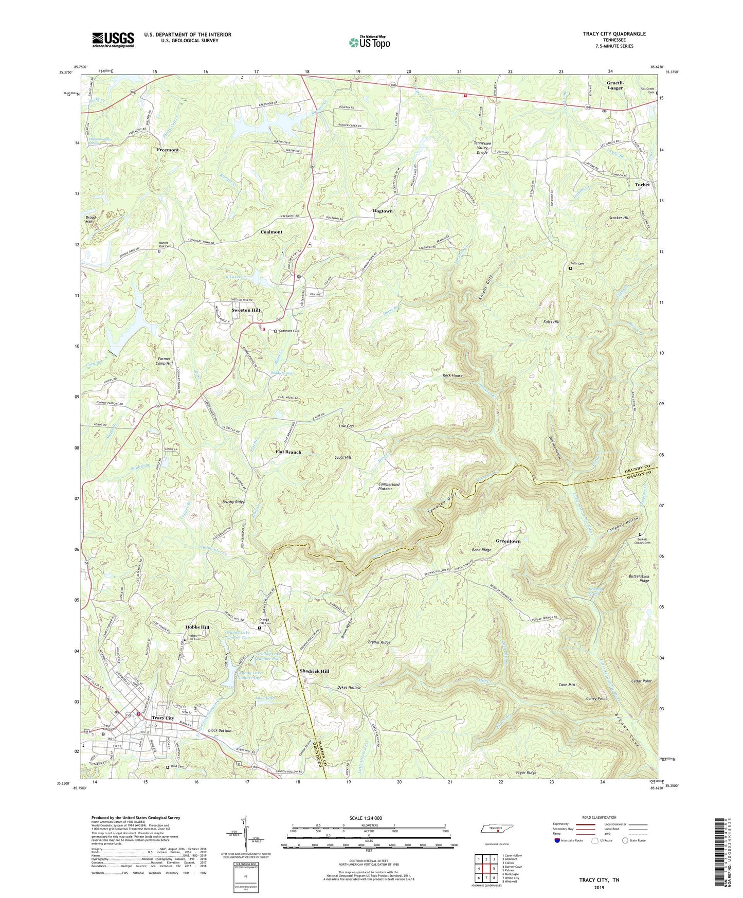
2019 topographic map quadrangle Tracy City in the state of Tennessee. Scale: 1:24000. Based on the newly updated USGS 7.5' US Topo map series, this map is in the following counties: Grundy, Marion. The map contains contour data, water features, and other items you are used to seeing on USGS maps, but also has updated roads and other features. This is the next generation of topographic maps. Printed on high-quality waterproof paper with UV fade-resistant inks.
Quads adjacent to this one:
West: Burrow Cove
Northwest: Cane Hollow
North: Altamont
Northeast: Collins
East: Palmer
Southeast: Whitwell
South: White City
Southwest: Monteagle
Contains the following named places: B Lakes, Bearhole Hollow, Bevins Chapel, Big Creek Lake, Big Creek Utility Dam, Big Creek Utility Lake, Black Bottom, Black Creek, Bone Ridge, Bonnie Oak Cemetery, Brown Hollow, Brown Hollow School, Brushy Ridge, Bryant Ridge, Burkett Chapel, Burkett Chapel Cemetery, Campbell Hollow, Cane Mountain, Caney Point, Cannon Hollow, Cedar Point, City of Coalmont, City of Gruetli-Laager, Clifty Creek, Coalmont, Coalmont Cemetery, Coalmont Elementary School, Coalmont Fire Department, Coalmont Post Office, Copper Branch, Davis Branch, Dogtown, Double Branch, Douglass Creek, Dripping Spring, Dykes Hollow, Fall Creek Cemetery, Fall Creek Church, Farmer Camp Hill, Flat Branch, Flat Branch School, Freemont, Freemont School, Fults Cemetery, Fults Hill, Greentown, Gruetli, Gruetli - Laager Post Office, Gruetli Laager Fire Department, Gruetli Station, Gruetli-Laager City Hall, Grundy Ambulance Services, Grundy County Fairgounds, Grundy County High School, Grundy Lake Dam Number Four, Grundy Lake Number Four, Grundy Lake Number One, Grundy Lake Number One Dam, Grundy Lake Number Two, Grundy Lake Number Two Dam, Grundy Lakes Game Preserve, Gum Spring Church, Higgenbotham Spring, Hobbs Hill, Hobbs Hill Cemetery, Hobbs Hill School, Hobbs HIll United Methodist Church, Holywater Creek, James K Shook School, Jenkins Creek, Johnson Creek, Knight Gulf, Lake Echo, Lake Echo Dam, Layne Branch, Little Mill Creek, Low Gap, Luchsinger Gap, Mill Creek, Mine Creek, Mount Etta Church, Mount Vernon School, Myers Hill Congregational Methodist Church, Myers Hill School, Nunley School, Orange Hill Cemetery, Orange Hill Church, Q Creek, Ramsey Lake, Ramsey Lake Dam, Reid Cemetery, Rock House, Roddy Springs, Ross Creek, Saint Bernard Church, Sanders Crossing, Scott Creek, Scott Hill, Scrum Branch, Sewanee Creek, Sewanee Gulf, Shadrick Hill, Stocker Hill, Sweeton Hill, Sweeton Hill School, Tennessee Valley Divide, Torbet, Tracy City, Tracy City Cemetery, Tracy City Division, Tracy City Fire Department, Tracy City Police Department, Tracy City Post Office, Tracy Elementary School, Victoria School, ZIP Codes: 37313, 37387