MyTopo
Whitwell Tennessee US Topo Map
Couldn't load pickup availability
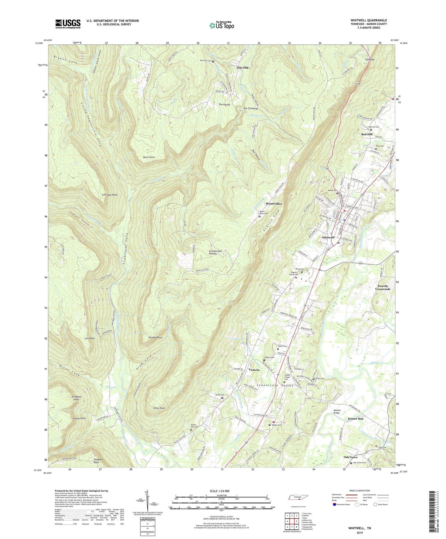
2022 topographic map quadrangle Whitwell in the state of Tennessee. Scale: 1:24000. Based on the newly updated USGS 7.5' US Topo map series, this map is in the following counties: Marion. The map contains contour data, water features, and other items you are used to seeing on USGS maps, but also has updated roads and other features. This is the next generation of topographic maps. Printed on high-quality waterproof paper with UV fade-resistant inks.
Quads adjacent to this one:
West: White City
Northwest: Tracy City
North: Palmer
Northeast: Daus
East: Ketner Gap
Southeast: Wauhatchie
South: Sequatchie
Southwest: South Pittsburg
This map covers the same area as the classic USGS quad with code o35085b5.
Contains the following named places: Alum Cove, Alum Creek, Bee Branch, Belmont Church, Bethel Church, Bridge Creek, Brown Spring Branch, Bryant Cove, Camp Glancy, Carengers Mill, City of Whitwell, Commissioner District 4, Coon Branch, Coppinger Chapel, Coppinger Cove, Coppinger School, Cowan Spring, Cowan Spring Branch, Davis Point, Distribute Branch, Dittany Point, Dixon Cove, Dixon Creek, Earl Patton Mine, English Cove, Fairview Church, George Kilgore Mine, Gordon Cemetery, Gott Cemetery, Grassy Point, Grays Creek, Green Mine, Gulf Spring, Gulf Springs Branch, Higgins Mine, Hudsons and Sanders Mine, Indian Cove, J R Patton Mine, Joe Kilgrow Mine, Johns Branch, Jones Point, Ketner Mill, Ketners Bridge, Kilgore Branch, Kilgore Family Cemetery, Lane and Shipley Mine, Layne Cemetery, Layne Chapel, Laynes Chapel Cemetery, Lick Branch, Lick Point, Little Sequatchie Cove, Low Gap Point, Marion County, McCulloughs Mine, Mikes Branch, Mill Branch, Morning Star Baptist Church, Mount Olive, Mount Olive Cemetery, Mount Olive School, Mount Zion Cemetery, Mountain, Nunley Number 1 Mine, Oak Grove, Oak Grove Cemetery, Oak Grove Cumberland Presbyterian Church, Oak Grove School, Orena Humphreys Public Library, Owl Hollow, Peter Cave Cove, Peter Cove Creek, Pilgrims Rest Church, Pine Hill, Pine Hill Cemetery, Pine Hill Church, Pine Hill School, Pocket Creek, Price Cemetery, Pryor Cemetery, Rankins Mine, Red Hill, Red Hill Cemetery, Red Hill School, Red Hill United Methodist Church, Sardis Cemetery, Sardis Church, Sawmill Creek, Sequatchie Volunteer Fire Department Station 2, Shelton Creek, Short Branch, Star Gap, Stinnette Point, The Chimneys, The Pocket, Turner Chapel, Union Cemetery, Victoria, Victoria Mine, Victoria School, Walden Cemetery, Walker Cemetery, West Valley Volunteer Fire Department, Whitewell Church of God, Whitwell, Whitwell Church of Christ, Whitwell City Hall, Whitwell Cumberland Presbyterian Church, Whitwell Division, Whitwell First Baptist Church, Whitwell High School, Whitwell Medical Center, Whitwell Mine, Whitwell Police Department, Whitwell Post Office, Whitwell School, Whitwell United Methodist Church, Whitwell Volunteer Fire Department, ZIP Code: 37397