MyTopo
Vonore Tennessee US Topo Map
Couldn't load pickup availability
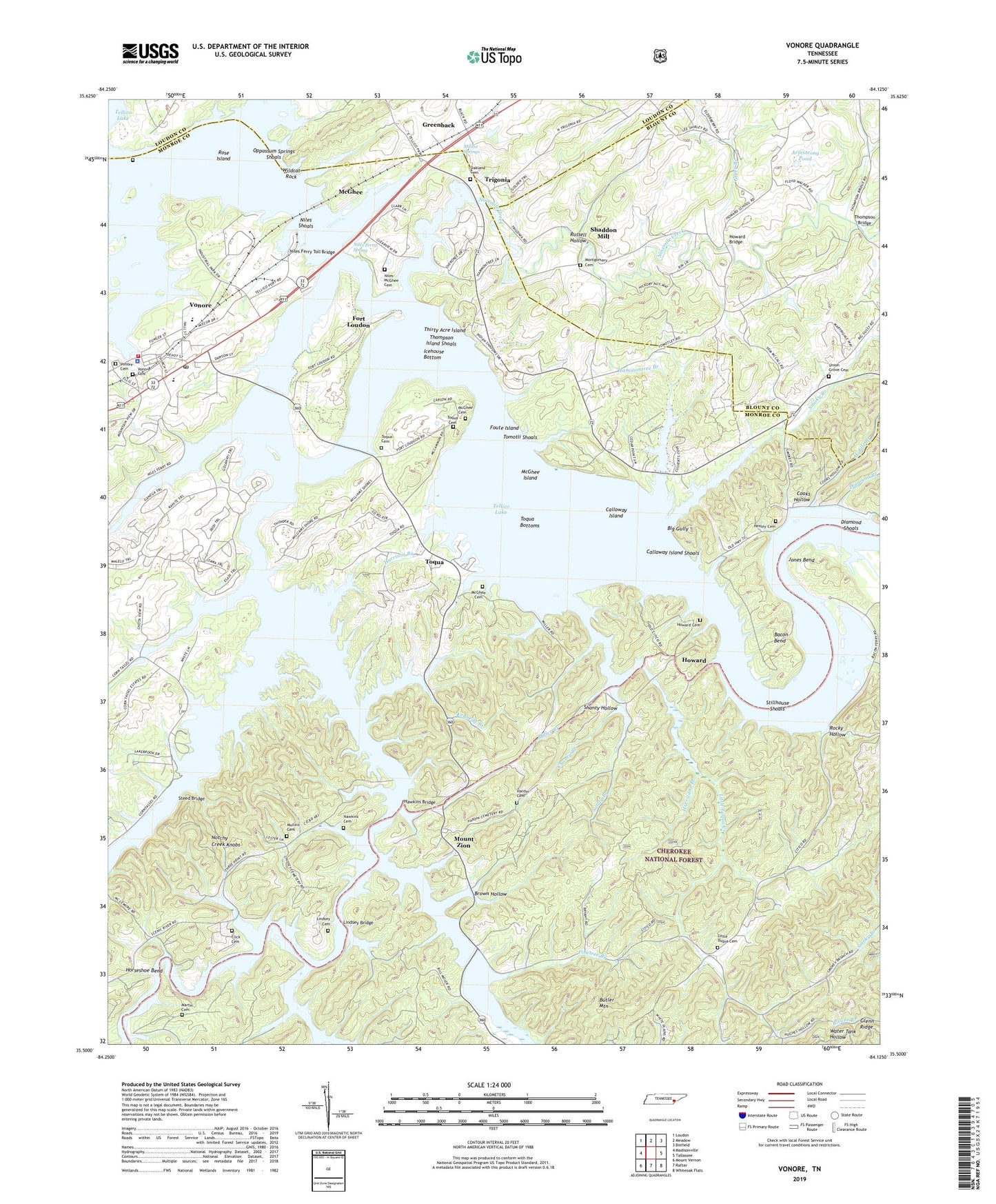
2019 topographic map quadrangle Vonore in the state of Tennessee. Scale: 1:24000. Based on the newly updated USGS 7.5' US Topo map series, this map is in the following counties: Monroe, Blount, Loudon. The map contains contour data, water features, and other items you are used to seeing on USGS maps, but also has updated roads and other features. This is the next generation of topographic maps. Printed on high-quality waterproof paper with UV fade-resistant inks.
Quads adjacent to this one:
West: Madisonville
Northwest: Loudon
North: Meadow
Northeast: Binfield
East: Tallassee
Southeast: Whiteoak Flats
South: Rafter
Southwest: Mount Vernon
Contains the following named places: Armstrong Pond, Bacon Bend, Bacon Ferry, Ballplay Creek, Ballplay Recreation Area, Big Gully, Black Pond, Brown Hollow, Butler Mountain, Callaway Island Shoals, Calloway Island, Chaney Branch, Chota, Chota School, Click Cemetery, Commissioner District 4, Cooks Hollow, Corntassel Airport, Corntassel Branch, David Craigs Fort, Diamond Branch, Diamond Shoals, East Fork Hicks Creek, Fort Loudon, Fort Loudoun Boat Launching Ramp, Fort Loudoun State Historic Area, Foster Bridge, Fourmile Bridge, Fourmile Creek, Foute Island, Gap Church, Greer Branch, Halls Ferry, Hammontree Branch, Hardin Cemetery, Harrison Branch, Hawkins Bridge, Hawkins Cemetery, Henley Cemetery, Hicks Creek, Horseshoe Bend, Howard, Howard Bridge, Howard Cemetery, Howard Pond, Howard School, Howards Chapel Baptist Church, Howards Mill Dam, Hurricane Branch, Icehouse Bottom, Island Creek, Jones Bend, Kahite, Kahite Census Designated Place, Kennedy Branch, Lindsey Bridge, Lindsey Cemetery, Little River, Little Tennessee School, Little Toqua Cemetery, Little Toqua Creek, Little Toqua Creek Church, Martin Cemetery, McGhee, McGhee Cemetery, McGhee Island, McGhee-Carson House Ruins, Mialoquo, Middle Branch, Militia Springs, Miller Branch, Montgomery Cemetery, Mount Zion, Mount Zion Baptist Church, Mountainville, Mullins Cemetery, Niles Ferry, Niles Ferry Spring, Niles Ferry Toll Bridge, Niles Shoals, Niles-McGhee Cemetery, Ninemile Creek, Notchy Creek, Notchy Creek Boat Launching Ramp, Notchy Creek Recreation Area, Oakland Cemetery, Oakland Methodist Church, Oppossum Springs Shoals, Pinetree Branch, Riverside, Riverside School, Rocky Hollow, Rose Island, Russell Hollow, Sandy Branch, Sequoyah Birthplace Memorial, Shaddon Mill, Shanty Hollow, Smoky Branch, Smoky Branch Boat Launching Ramp, Steed Bridge, Stillhouse Shoals, Tellico Blockhouse State Historic Site, Tellico Lake, Tellico River, Tennessee, Thirty Acre Island, Thompson Bridge, Thompson Island Shoals, Three Point Church, Three Points, Toconee School, Tommotley, Tomotla Ford, Tomotli Shoals, Toqua, Toqua Boat Launching Ramp, Toqua Bottoms, Toqua Cemetery, Toqua Church, Toqua Community Center, Toqua Creek, Toqua Recreation Area, Toqua School, Town of Vonore, Trigonia, Tuskeegee, Union Grove, Union Grove Cemetery, Union Grove School, Vonore, Vonore Baptist Church, Vonore Boat Dock, Vonore Boat Launching Ramp, Vonore Cemetery, Vonore Division, Vonore Elementary School, Vonore High School, Vonore Police Department, Vonore Post Office, Vonore United Methodist Church, Vonore Volunteer Fire Department Station 1, Vonore-Niles Ferry Industrial Park, Wear Cemetery, West Fork Hicks Creek, Wildcat Rock, Williamson Branch