MyTopo
Tallassee Tennessee US Topo Map
Couldn't load pickup availability
Also explore the Tallassee Forest Service Topo of this same quad for updated USFS data
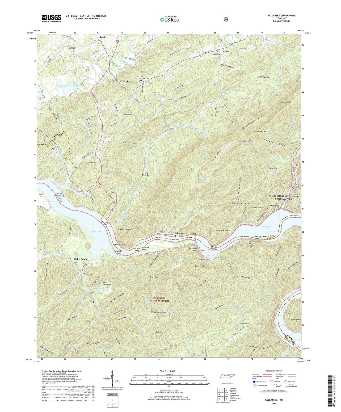
2022 topographic map quadrangle Tallassee in the state of Tennessee. Scale: 1:24000. Based on the newly updated USGS 7.5' US Topo map series, this map is in the following counties: Blount, Monroe. The map contains contour data, water features, and other items you are used to seeing on USGS maps, but also has updated roads and other features. This is the next generation of topographic maps. Printed on high-quality waterproof paper with UV fade-resistant inks.
Quads adjacent to this one:
West: Vonore
Northwest: Meadow
North: Binfield
Northeast: Blockhouse
East: Calderwood
Southeast: Tapoco
South: Whiteoak Flats
Southwest: Rafter
This map covers the same area as the classic USGS quad with code o35084e1.
Contains the following named places: Allegheny Church, Allegheny Springs, Babcock Trestle, Billy Ridge, Birchfield Church, Bolden Knight Bluff, Brown Hollow, Bryant Hollow, Buchannan Mountain, Bunker Hill, Buzzard Roost, Caringer, Carringer Branch, Chambers Hollow, Chilhowee, Chilhowee Dam, Chilhowee Lake, Chilhowee Shoals, Chilhowey, Chilogatee Gap, Chota, Chris Branch, Citico, Citico Baptist Church, Citico Beach, Citico Bridge, Citico Cemetery, Citico Creek, Citico Recreation Area, Citico Volunteer Fire Department, Clear Creek, Cochran Creek, Cockspur Branch, Cockspur Knob, Cockspur Lead, Cody Field Branch, Cook Hollow, Cooper Branch, Cooper Gap, Cooper Hollow, Cove Lake, Cure-al Branch, Deadmans Curve, Dog Gap, Dry Prong, Duncan Branch, Fish Trap Shoals, Flagpole Hill, Floyd Sellers Hollow, Fortner Branch, Four Mile Baptist Church, Four Mile Cemetery, Four Mile Creek Shoals, Fourmile Creek, Grant Hollow, Halfway Town, Hammontree Branch, Happy Top Church, Hardwood Gap, Harrison Branch, Harrison Branch Boat Launching Ramp, Harrison Branch Recreation Area, Harrison Island, Hogpen Hollow, Hute Hollow, Ipe, Irwin Branch, Jakes Creek, Jones Cemetery, Jones Ferry, Jones Island, Kagleys Chapel Baptist Church, Kagleys Chapel Cemetery, Keener Cemetery, Kirkland Hollow, Kirkland Island, Lakey Woods Knob, Lanier, Lanier Elementary School, Lanier High School, Lawson Hollow, Lick Branch, Little Fourmile Creek, Lower Chilhowee Cemetery, Lower Chilhowee Church, Maroney Hollow, Maroney Top, McCulloch Branch, McMurray Cemetery, McMurray Shoals, McSpadden Branch, Miry Branch, Morton Bluff, Mulberry Creek, Mulberry Lake, Murk Branch, Nelson Chapel Cemetery, Nelson Chapel Church of Christ, Nelson Ridge, Nighway Branch, Noah Dunkin Hollow, Parnell Branch, Pictured Pine Knob, Polly Ann Hollow, Poplar Spring, Poplar Spring Branch, Pumpkin Center, Rough Prong, Ryall Branch, Scona Lodge, Scona Lodge Ferry, Sellers Branch, Shelley Ridge, Shingle Mountain, Short Haul Gap, Short Mountain, Slide Hollow, Smoky Branch, Spradling Branch, Stillhouse Hollow, Stony Grave Gap, Stony Grave Hollow, Stratton Knob, Stratton Shoals, Swirl Hole Bend, Tallasee Creek, Tallassee, Tallassee Boat Launching Ramp, Tallassee Ford, Tallassee Post Office, Tallassee Recreation Area, Tank Hollow, Tarkiln Branch, Tellassee, Tipton Orchard Hollow, Trail Ridge, Trestle Branch, Turkeypen Bluff, Turkeypen Hollow, Turkeypen Lake, Turkeypen Lake Dam, Vaden Hollow, Walker Branch, Wellsville, Wellsville Mill, Williamsons Chapel Cemetery, Williamsons Chapel Methodist Church