MyTopo
Brenham Texas US Topo Map
Couldn't load pickup availability
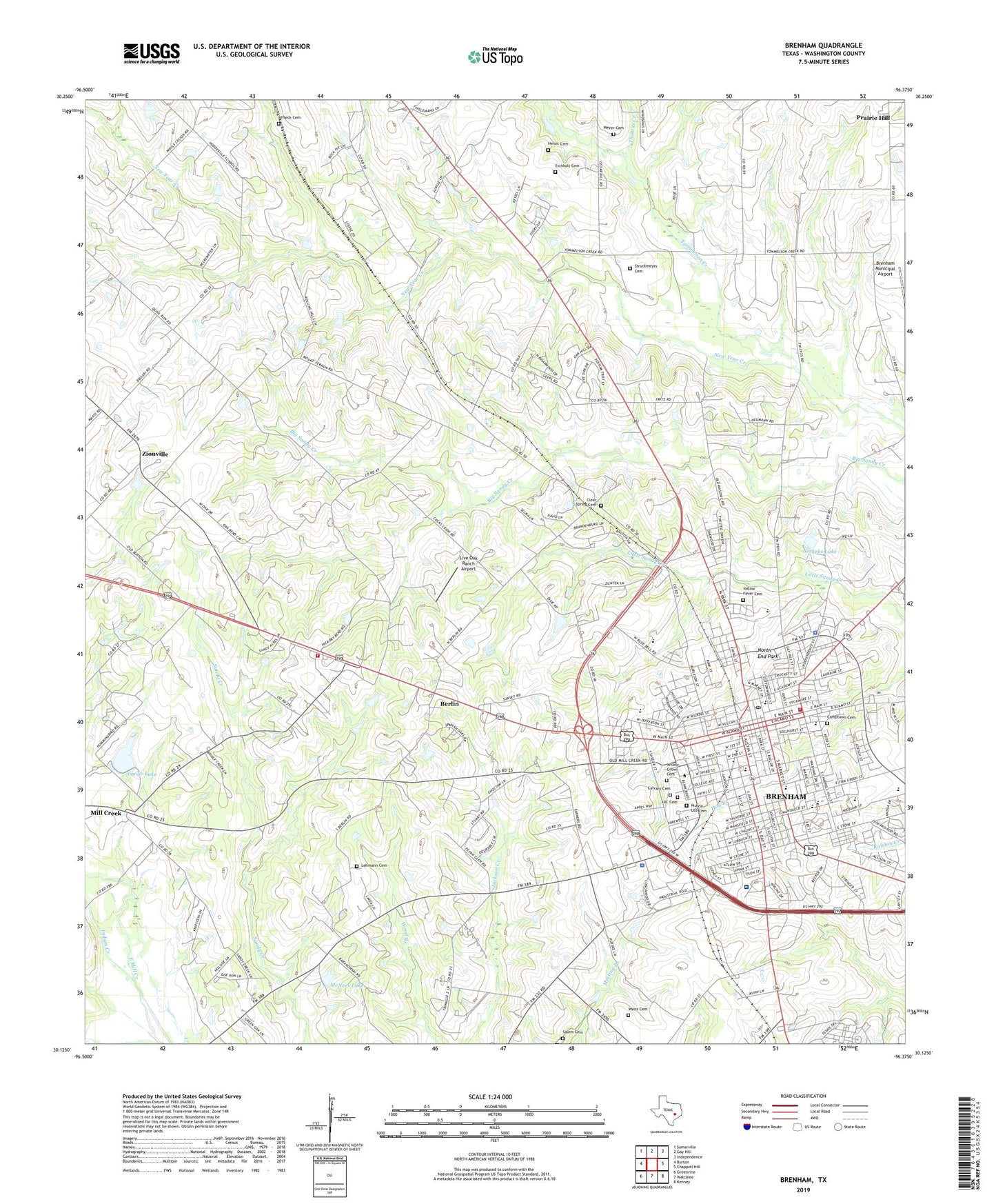
2019 topographic map quadrangle Brenham in the state of Texas. Scale: 1:24000. Based on the newly updated USGS 7.5' US Topo map series, this map is in the following counties: Washington. The map contains contour data, water features, and other items you are used to seeing on USGS maps, but also has updated roads and other features. This is the next generation of topographic maps. Printed on high-quality waterproof paper with UV fade-resistant inks.
Quads adjacent to this one:
West: Burton
Northwest: Somerville
North: Gay Hill
Northeast: Independence
East: Chappell Hill
Southeast: Kenney
South: Welcome
Southwest: Greenvine
Contains the following named places: Affleck Cemetery, Alamo School, Allcorn-Kokemoor Farmstead, Almot Schlenker House, Alton Elementary School, Bassett and Bassett Banking House, Baylor Scott And White Medical Center Brenham, Becker-Hildebrandt House, Berlin, Berlin Volunteer Fire Department, Blue Bell Creameries Complex, Bnai Abraham Cemetery, Brenham, Brenham Alternative School, Brenham City Hall, Brenham Division, Brenham Elementary School, Brenham Fire Department, Brenham High School Gymnasium, Brenham Junior High School, Brenham Police Department, Brenham Post Office, Brenham School, Brenham Sports Complex, Brenham Water Works, Brockschmidt-Miller House, Calvary Cemetery, Camptown Cemetery, City of Brenham, Clear Springs Cemetery, Doctor Robert Lenert House, East Brenham Historict District, Edgar Matchett House, Edmund Holle House, Eichholt Cemetery, F W Schuerenberg House, Firemans Park, Giddings-Stone Mansion, Giddings-Wilkin House, Giddings-Wilkin House Museum, Harrisburg School, Hattie Powers Park, Heisic Cemetery, HIC Cemetery, Indian Creek, Jackson Park, KTTX-AM (Brenham), KULF-FM (Brenham), KWHI-FM (Brenham), Lange Dam, Lange Lake, Lehmann Cemetery, Live Oak Ranch Airport, McNees Lake, McNees Lake Dam, Meyer Cemetery, Mill Creek, Milroy Hospital, Mount Pilgrim Church, Mount Zion Methodist Church, North End Park, Pampell-Day House, Pickard High School, Prairie Hill, Prairie Lea Cemetery, R A Schuerenberg House, Railroad Lake, Railroad Lake Dam, Reichardt-Low House, Saint Johns Church, Saint Jude Hospital, Saint Marys Catholic Church, Saint Marys School, Sandy Creek Church, Santa Fe Railway Company Freight Depot, Schlenker-Kolwes House, Schmidt House, Seekeks Lake, Southern Pacific Railroad Freight Depot, Struckmeyer Cemetery, Synagogue B'nai Abraham, Thomas Creek, Tommelson Creek, W E Seelhorst House, Washington County, Washington County EMS Station 1, Washington County Jail, Washington County Sheriff's Office, Weiss Cemetery, West End School, Willow Grove Cemetery, Wood-Hughes House, Yellow Fever Cemetery, Zionville, ZIP Code: 77833