MyTopo
Crosby Texas US Topo Map
Couldn't load pickup availability
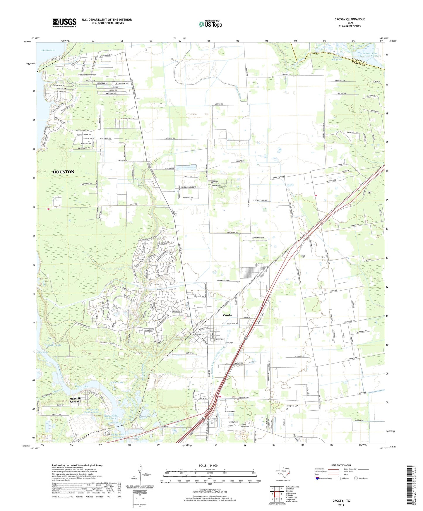
2019 topographic map quadrangle Crosby in the state of Texas. Scale: 1:24000. Based on the newly updated USGS 7.5' US Topo map series, this map is in the following counties: Harris, Liberty. The map contains contour data, water features, and other items you are used to seeing on USGS maps, but also has updated roads and other features. This is the next generation of topographic maps. Printed on high-quality waterproof paper with UV fade-resistant inks.
Quads adjacent to this one:
West: Harmaston
Northwest: Moonshine Hill
North: Huffman
Northeast: Dayton
East: Sheeks
Southeast: Mont Belvieu
South: Highlands
Southwest: Jacinto City
Contains the following named places: Adlong Ditch, Antioch Church, Bakers Lake, Barrett, Barrett Primary School, Black Lake, Boheman Hall, Cedar Grove Church, Cedar Grove Park, Crosby, Crosby Branch Library, Crosby Cemetery, Crosby Census Designated Place, Crosby Chamber of Commerce, Crosby Church, Crosby Church of Christ, Crosby Elementary School, Crosby High School, Crosby Kindergarten, Crosby Library, Crosby Meadows, Crosby Middle School, Crosby Plaza Shopping Center, Crosby Post Office, Crosby Sports Complex, Crosby Stadium, Crosby United Methodist Church, Crosby Volunteer Fire Department Station 81, Crosby Volunteer Fire Department Station 82, Crosby Volunteer Fire Department Station 83, Crosby Volunteer Fire Department Station 84, Crosby Woods, Dunham Field, Enderli Reservoir, Enderli Reservoir Dam, Evergreen Cemetery, Flying F Ranch Airport, Fontain, Gordon Lake, Granite Creek, Greenwood Church, Gum Gully, Happy Hideaway, Harris County Emergency Services District 80, Harvest Baptist Church, Harvest Time Church of God, Heathergate, Jackson Bayou, Little Eddy, Lynch Cemetery, Magnolia Gardens, Mount Zion Missionary Baptist Church, Newport Elementary School, Northeast Freeway Baptist Church, Northeast Harris Division, Our Shepherd Church, Rankin Oil Field, Riverdale Church, Roeder Airport, Rustic Acres, Sacred Heart Catholic Church, Sacred Heart Cemetery, Sacred Heart School, San Jacinto River Authority Canal, Simms Lake, Sludge Fill Pond Levee Number 1 Dam, Sludge Fill Pond Number 1, Sludge Pond Levee Number 1 Dam, Sludge Pond Levee Number 2 Dam, Sludge Pond Number 1, Sludge Pond Number 2, Spring Gully, Tall Cedars, Tank Lake, Terramare, United Church, W Scott Frost Reservoir Number 1, W Scott Frost Reservoir Number 1 Levee, W Scott Frost Reservoir Number 3, W Scott Frost Reservoir Number 3 Levee, ZIP Code: 77532