MyTopo
Mont Belvieu Texas US Topo Map
Couldn't load pickup availability
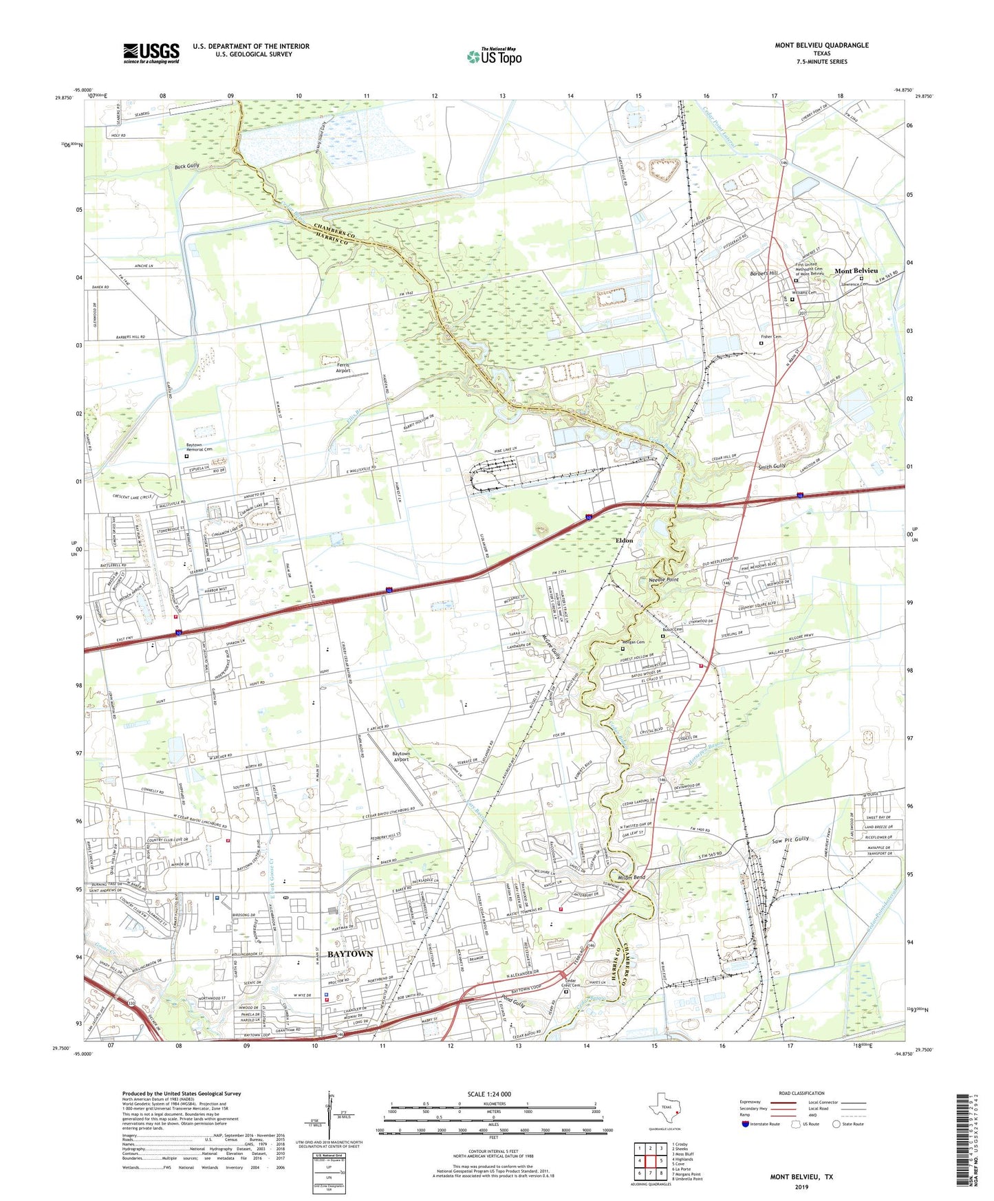
2022 topographic map quadrangle Mont Belvieu in the state of Texas. Scale: 1:24000. Based on the newly updated USGS 7.5' US Topo map series, this map is in the following counties: Harris, Chambers. The map contains contour data, water features, and other items you are used to seeing on USGS maps, but also has updated roads and other features. This is the next generation of topographic maps. Printed on high-quality waterproof paper with UV fade-resistant inks.
Quads adjacent to this one:
West: Highlands
Northwest: Crosby
North: Sheeks
Northeast: Moss Bluff
East: Cove
Southeast: Umbrella Point
South: Morgans Point
Southwest: La Porte
This map covers the same area as the classic USGS quad with code o29094g8.
Contains the following named places: Acadian Ambulance Service of Texas, Alamo Elementary School, Allenbrook, Baker Road Baptist Church, Barbers Hill, Barbers Hill Oil Field, Bayou Church, Baytown Airport, Baytown Chamber of Commerce, Baytown Christian Academy, Baytown Division, Baytown Fairgrounds, Baytown Fire and Rescue Services, Baytown Fire and Rescue Station 1, Baytown Fire and Rescue Station 3, Baytown Police Department, Baytown Police Department Robert P Merchant Police Training Facility, Baytown Post Office, Baytown Sports Complex, Baytown Youth Fair, Berea Church of God in Christ, Buck Gully, Busch Cemetery, Carver Elementary School, Cary Bayou, Cedar Bayou, Cedar Bayou Baptist Church, Cedar Bayou Junior High School, Cedar Bayou Stadium, Cedar Bayou United Methodist Church, Cedar Crest Cemetery, Cedar Point Lateral, Center Baytown Shopping Center, Chambers County Constable's Office Precinct 6, Chambers County Task Force, Chaparral Village, Chevron Chemical Company Heliport, City of Baytown, City of Mont Belvieu, Country Club Cove, Country Club Estates, Country Club Gardens, Country Club Oaks, Crockett Elementary School, Earthman Memory Gardens Cemetery, East Fork Goose Creek, Eldon, Ellis Branch, Ferris Airport, First Baptist Church of Baytown, First United Methodist Cemetery of Mont Belvieu, Fisher Cemetery, G B I Heliport, George H Gentry Junior High School, Ginger Green, Goose Creek Country Club, Goose Creek Shopping Center, Goosecreek Church of Christ, Gospel Lighthouse Church, Harris County Constable's Office Precinct 3, Harris County Courthouse, Hickory Island Gully, Horsepen Bayou, Houston Methodist Baytown Hospital, Lawrence Cemetery, League of Women Voters Park, Life Church of the Assembly of God, Little Rock Church, Living Hope Church of God, McGee Gully, Memorial Assembly of God Church, Milam Bend, Mont Belvieu, Morgan Cemetery, Needle Point, Peace Tabernacle United Pentecostal Church, Pond Gully, Port Arthur Ship Canal, Quail Hollow, Rogers Airport, Saint John Catholic Church, San Jacinto Methodist Hospital Heliport, San Jacinto Place, San Jacinto Shopping Center, Saw Pit Gully, Shiloh Church, Smith Gully, Stallworth Stadium, Stephen F Austin Elementary School, Stephen F Austin School, Sterling High School - Goosecreek, Sterling High School Baseball Field, Templo Bethel, Victory Baptist Church, West Fork Goose Creek, Williams Cemetery, Willow Creek Shopping Center, ZIP Code: 77521