MyTopo
Denison Dam Texas US Topo Map
Couldn't load pickup availability
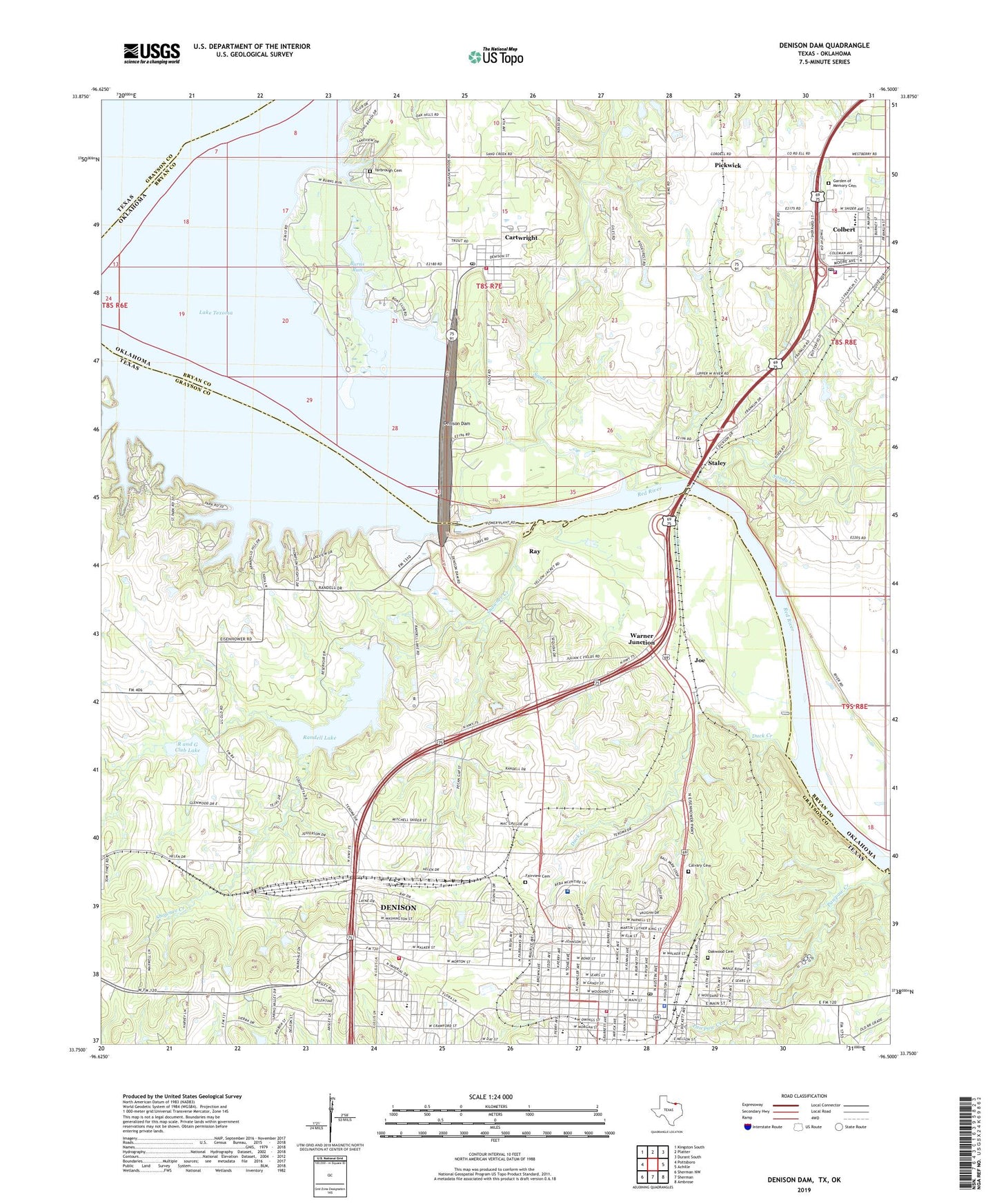
2022 topographic map quadrangle Denison Dam in the states of Texas, Oklahoma. Scale: 1:24000. Based on the newly updated USGS 7.5' US Topo map series, this map is in the following counties: Grayson, Bryan. The map contains contour data, water features, and other items you are used to seeing on USGS maps, but also has updated roads and other features. This is the next generation of topographic maps. Printed on high-quality waterproof paper with UV fade-resistant inks.
Quads adjacent to this one:
West: Pottsboro
Northwest: Kingston South
North: Platter
Northeast: Durant South
East: Achille
Southeast: Ambrose
South: Sherman
Southwest: Sherman NW
This map covers the same area as the classic USGS quad with code o33096g5.
Contains the following named places: Antioch Baptist Church, B McDaniel Middle School, Baers Ferry, Bethel Community Baptist Church, Burns Run, Calvary Cemetery, Cartwright, Cartwright Census Designated Place, Cartwright Fire Department, Cartwright Post Office, Central School, Church of Christ, City of Denison, Clifton House Hotel, Coffman - Layne Cemetery, Colbert, Colbert Division, Colbert Emergency Medical Services, Colbert Fire Department, Colbert High School, Colbert Middle School, Colbert Police Department, Colbert Post Office, Colbert Westward Elementary School, Denison, Denison Church of the Nazarene, Denison City Hall, Denison Commercial Historic District, Denison Dam, Denison Fire Department Central Station 1, Denison Fire Department West Side Station 2, Denison Police Department, Denison Post Office, Duck Creek, East Baptist Church, Eisenhower State Park, Eisenhower State Park Trail, Emmanuel Baptist Church, Ernst Martin Kohl Building, Fairview Cemetery, First Baptist Church, Forest Park, Garden of Memory Cemetery, George Braun House, Grayson County Constable's Office Precinct 2, Haven Chapel Methodist Church, Hopewell Baptist Church, Houston Elementary School, Houston School, Joe, Kidd-Private Airport, Layne Elementary School, Layne School, Magnolia Cemetery, Mayes Elementary School, Mount Obed Baptist Church, Mount Pleasant Baptist Church, Mount Zion Baptist Church, Munson Park, Oakwood Cemetery, Pathways High School, Pawpaw Creek, Pickwick, Price Memorial United Methodist Church, R and G Club Lake, R and G Lake Dam, Randell Lake, Randell Lake Dam, Ray, Raynal School, Reba McIntire Center for Rehabilitation, Red River City, Red River Railroad Museum, Saint Emanuel Church of God in Christ, Saint Luke Church, Saint Paul Baptist Church, Sand Creek, Sandy Creek, Shawnee, Shawnee Creek, Staley, Terrell Elementary School, Texoma Medical Center Restorative Care Hospital, Town of Colbert, Victory Baptist Church, Waples Memorial United Methodist Church, Warner Junction, Washington Street Church of Christ, Yarbrough Cemetery, ZIP Codes: 74731, 75020