MyTopo
Lancaster Texas US Topo Map
Couldn't load pickup availability
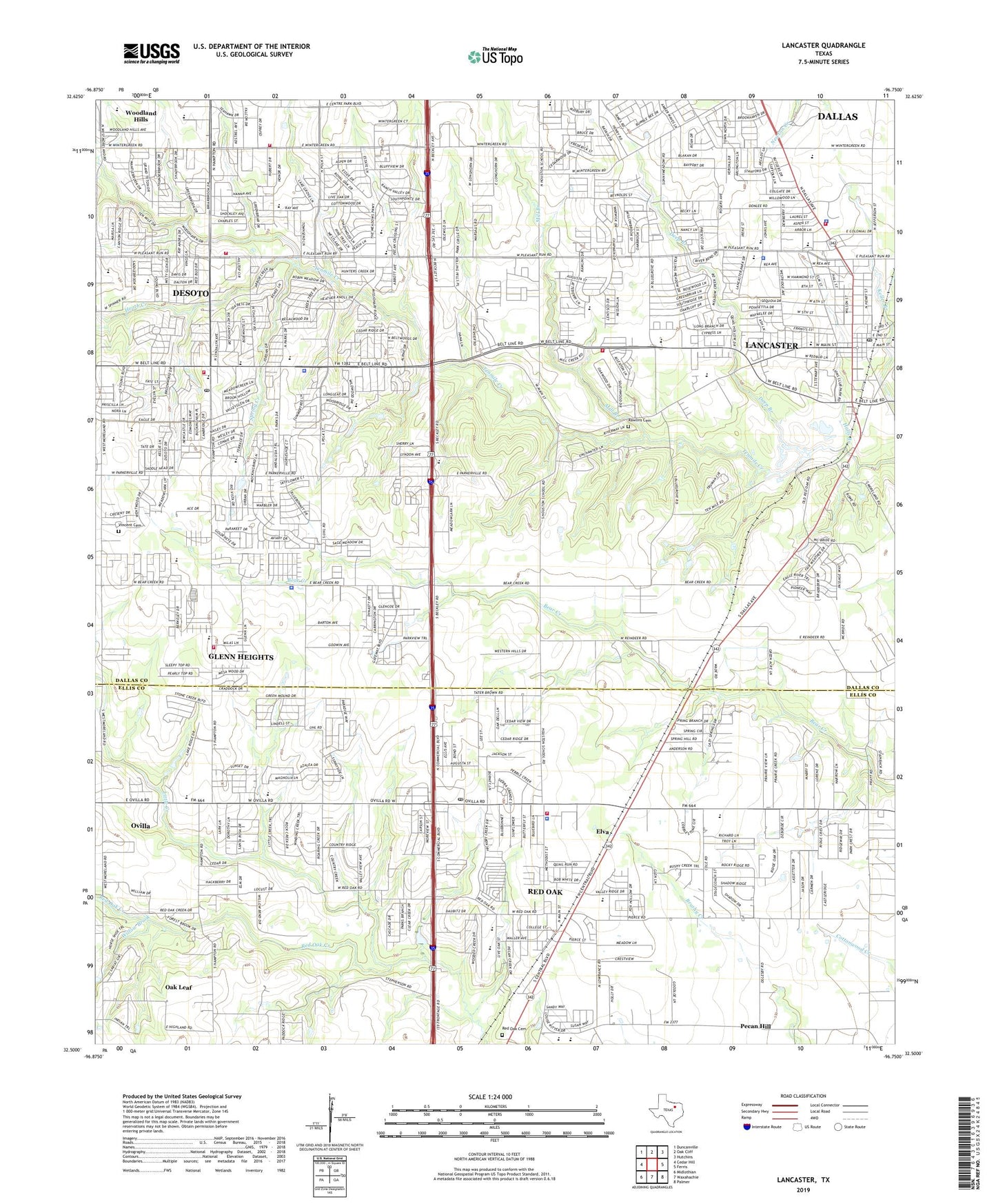
2019 topographic map quadrangle Lancaster in the state of Texas. Scale: 1:24000. Based on the newly updated USGS 7.5' US Topo map series, this map is in the following counties: Dallas, Ellis. The map contains contour data, water features, and other items you are used to seeing on USGS maps, but also has updated roads and other features. This is the next generation of topographic maps. Printed on high-quality waterproof paper with UV fade-resistant inks.
Quads adjacent to this one:
West: Cedar Hill
Northwest: Duncanville
North: Oak Cliff
Northeast: Hutchins
East: Ferris
Southeast: Palmer
South: Waxahachie
Southwest: Midlothian
Contains the following named places: Advicare Ambulance Service, Amber Terrace Intermediate School, Ames Road Church, Bear Creek Baptist Church, Bear Creek Ranch, Bear Creek Ranch Census Designated Place, Beckley City Chapel, Belt Line Elementary School, Brook Hollow Baptist Church of De Soto, Camp Pinkston, Captain R A Rawlins House, Carroll Air Park, Church of Christ, Church of Christ Cold Springs, City of DeSoto, City of Glenn Heights, City of Lancaster, City of Oak Leaf, City of Red Oak, City of Red Oak Municipal Center, Clover Haven Church, Crossroads Baptist Church, D High School Freshman Campus, Dallas Avenue Church of Christ, De Soto Assembly of God Church, De Soto Church of the Nazarene, De Soto Community Church, De Soto High School, De Soto Presbyterian Church, Deep Branch, DeSoto, DeSoto City Hall, Desoto East Junior High School, DeSoto Fire / Rescue, Desoto Fire Rescue Station 261, Desoto Fire Rescue Station 262, DeSoto Police Department, DeSoto Post Office, Desoto West Junior High School, Eagle Stadium, East Ridge Baptist Church, Eastridge Elementary School, Elva, Faith Family Academy of Oak Cliff, First Assembly of God Church of Lancaster, First Baptist Church, First Baptist Church of De Soto, First Baptist Church of Lancaster, First Pentecostal Church, First Presbyterian Church of Lancaster, Glenn Heights, Glenn Heights City Hall, Glenn Heights Fire Department, Glenn Heights Police Department, Grace Covenant Church, Grimes Park, Halls Branch, Heath Creek, Jordan Baptist Church, Lancaster, Lancaster City Hall, Lancaster Community Baptist Church, Lancaster Elementary School, Lancaster Fire Department Station 1, Lancaster Fire Department Station 3, Lancaster High School, Lancaster Independent School District Police Department, Lancaster Park Baptist Church, Lancaster Police Department, Lancaster Post Office, Landmark Baptist Church, Lion Club Park, Little Creek, Meadow Church, Meadows Intermediate School, Medical Center at Lancaster, Mill Branch, Millbrook Baptist Church, Millbrook Elementary School, Miracle Temple Fellowship Church, Miracle Valley Church of God in Christ, Missionary Church, Mosley Park, New Life Church of God in Christ, Northside Elementary School, Oak Leaf, Oak Leaf City Hall, One'ness Church, Pleasant Run Elementary School, Pleasant Run School, Randlett House, Rawlins Cemetery, Red Oak, Red Oak Cemetery, Red Oak Elementary School, Red Oak Fire Station Rescue, Red Oak Police Department, Red Oak Post Office, Rocky Crest High School, Rolling Hills Elementary School, Ruby Young Elementary School, Saint Martins Church, Saint Martins Episcopal Church, Saint Paul Free Will Baptist Church, Shekinah Tabernacle Baptist Church, Shields Elementary School, Solomon Temple Missionary Baptist Church, Spring Creek, Tiger Field, Trinity Temple Baptist Church, True Vine Church of God in Christ, United Church of God International, Vincent Cemetery, West Main Elementary School, Westchester Fellowship Baptist Church, Westridge Church, Willow Brook, Wintergreen Missionary Church, Zeigler Park, ZIP Codes: 75115, 75134, 75146, 75154