MyTopo
Laredo South Texas US Topo Map
Couldn't load pickup availability
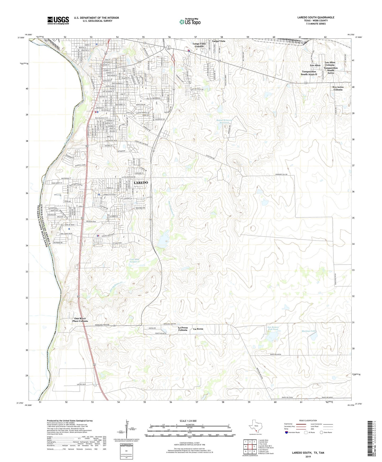
2019 topographic map quadrangle Laredo South in the state of Texas. Scale: 1:24000. Based on the newly updated USGS 7.5' US Topo map series, this map is in the following counties: Webb. The map contains contour data, water features, and other items you are used to seeing on USGS maps, but also has updated roads and other features. This is the next generation of topographic maps. Printed on high-quality waterproof paper with UV fade-resistant inks.
Quads adjacent to this one:
West: Laredo West OE S
Northwest: Laredo West
North: Laredo East
Northeast: Tios Creek
East: Blancas Creek North
Southeast: Blancas Creek South
Southwest: Isla Mesteno
Contains the following named places: A R Sanchez Lake, A R Sanchez Lake Dam, All - American Ambulance Service, Apostolic Assembly Church, Chacon Creek, Clark Dam, D-5 Acres Colonia, Daiches Elementary School, Dairy Crossing, Dam Number 1, Doctor Leo Cigarroa High School, H B Zachry Elementary School, J Kawas Elementary School, Joaquin Cigarroa Middle School, Kennedy Zapata Elementary School, KLAR-AM (Laredo), La Presa, La Presa Census Designated Place, La Presa Colonia, Laredo Community College Police Office South Campus, Laredo Fire Department Station 11, Laredo Fire Department Station 14, Laredo Fire Department Station 2, Laredo Police Substation Patrol East Beat 12, Laredo Police Substation Patrol East Beat 13, Laredo Police Substation Patrol East Beat 15, Laredo Police Substation Patrol East Beat 16, Laredo Police Substation Patrol East Beat 17, Larga Vista, Larga Vista Census Designated Place, Larga Vista Colonia, Leon Daiches School, Leyendecker Lake, Leyendecker Lake Dam, Link Lake Number 1, Link Lake Number 1 Dam, Link Lake Number 2, Link Lake Number 2 Dam, Los Altos Census Designated Place, Los Altos Colonia, Martinez Lake, Martinez Lake Dam, Masterson School, Minnie Martin Lake, Minnie Martin Lake Dam, Octavio School, Old Milwaukee East Colonia, Old Milwaukee West Colonia, One River Place Colonia, Perez Elementary School, Rafael B Garcia Dam, Rafael B Garcia Reservoir, Ranch Tank, Ruiz Elementary School, Salinas Elementary School, San Idelfonso Creek, San Ramon Dam, San Ramon Fish Pond, Santo Nino Elementary School, Santo Nino School, Seventh Day Adventist Church, Tanquecitos South Acres Census Designated Place, Tanquecitos South Acres Colonia, Tanquecitos South Acres II Census Designated Place, Tapon Tank, United D D Hachar Elementary School, United South High School, United South Middle School, Varal Tank, Webb County Constable's Office Precinct 2, Wright Dam Number 1, Wright Dam Number 2, Wright Dam Number 3, Wright Dam Number 4, Zacata Creek