MyTopo
McKinney East Texas US Topo Map
Couldn't load pickup availability
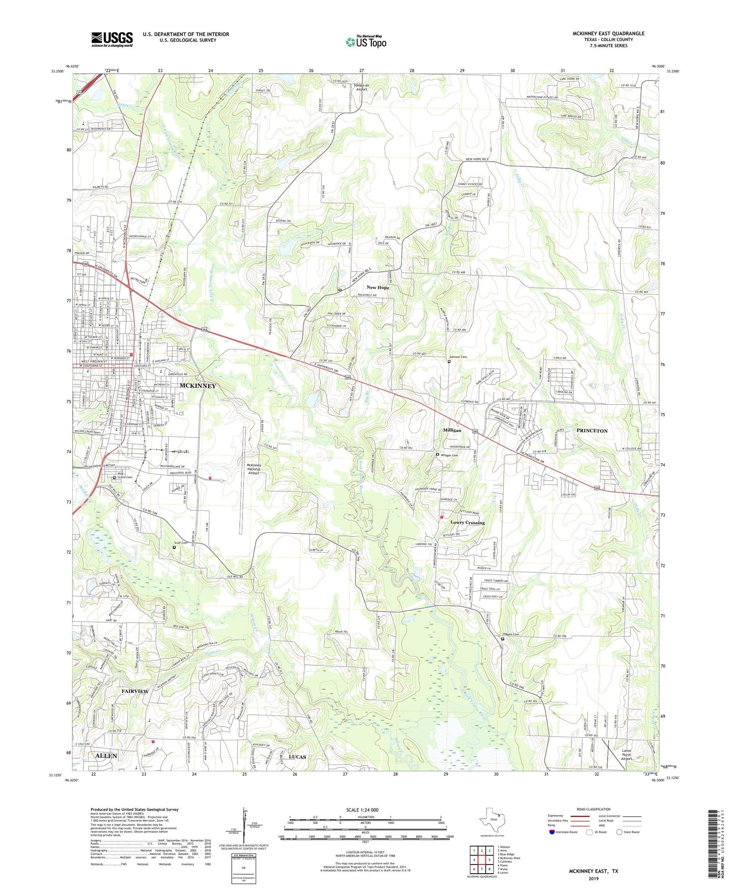
2019 topographic map quadrangle McKinney East in the state of Texas. Scale: 1:24000. Based on the newly updated USGS 7.5' US Topo map series, this map is in the following counties: Collin. The map contains contour data, water features, and other items you are used to seeing on USGS maps, but also has updated roads and other features. This is the next generation of topographic maps. Printed on high-quality waterproof paper with UV fade-resistant inks.
Quads adjacent to this one:
West: McKinney West
Northwest: Weston
North: Anna
Northeast: Blue Ridge
East: Culleoka
Southeast: Lavon
South: Wylie
Southwest: Plano
Contains the following named places: Act Academy at J L Greer, Beverly-Harris House, Bible Baptist Church, Big Branch, Biggers, Board-Everett House, Caldwell Elementary School, Church of Christ, Church of God, Church of the Nazarene, City of Lowry Crossing, Clemons Creek, Collin County, Collin County Central Museum at the Old Post Office, Collin County Courthouse, Collin County Fire Marshal's Office, Collin County Mill and Elevator Company Building, Collin County Water Department, Collin McKinney Cabin, Community Baptist Church, Crouch-Perkins House, Davis-Hill House, Dunn Memorial Church, E W Kirkpatrick House and Barn, East Fork Church, Estes House, Eternity Community Church, F C Faires House, Faires-Bell House, Fairview Fire Station 2, Faith Memorial Baptist Church, Finch Elementary School, Finch Park, First Baptist Church, First Church of God and Christ, First Spanish Assembly of God Church, Foote-Crouch House, Friendship Church, Good Hope Baptist Church, Greater Hope Holiness Church, H L Davis House, Heard Natural Science Museum, Heard-Craig House, Higgins Cemetery, Hillcrest Country Club, Hill-Webb Grain Elevator, Honey Creek, J P Nenney House, J R Coggins House, J S Dowell House, Jeans Creek, Jim B Goodner House, Joe E Dulaney House, John B Hill House, John C Rhea House, John H Bingham House, John H Ferguson House, John Johnson House, John R Brown House, Johnson Cemetery, Joseph Field Dulaney House, L A Scott House, Lavon North Airport, Lively Hill Church of God in Christ, Lovejoy Elementary School, Lowry Crossing, Lowry Crossing Fire Department, McKinney, McKinney City Hall, McKinney City Marshal's Office, McKinney Commercial Historic District, McKinney Cotton Compress Plant, McKinney Cotton Mill Historic District, Mckinney Fellowship Bible Church, McKinney Fire Department Station 4, McKinney Fire Department Wysong Central Fire Station, McKinney High School, McKinney National Airport, McKinney Residential Historic District, Milligan, Milligan Cemetery, Mount Pilgrim Freewill Baptist Church, Mouzon Park, Mrs J C King House, New Hope, New Hope Town Hall, New Jerusalem Missionary Baptist Church, Newsome-King House, North Baptist Church, North Ward School, Old McKinney Hospital, Pecan Grove Cemetery, Pentecostal Church of God, Phi Air Medical 2, Princeton City Hall, Princeton Division, R L Waddill House, Redeemer Presbyterian Church, Saint Paul Missionary Baptist Church, Scalf Cemetery, Shilo Church of God and Christ, Sloan Creek, Soil Conservation Service Site 12 Dam, Soil Conservation Service Site 12 Reservoir, Soil Conservation Service Site 24 Dam, Soil Conservation Service Site 24 Reservoir, Soil Conservation Service Site 53 Dam, Soil Conservation Service Site 53 Reservoir, South Ward School, Square Air Airport, StarPlus Emergency Medical Service, Thomas Johnson House, Thomas W Wiley House, Town of Fairview, Town of New Hope, Truth Chapel Church, U P Clardy House, United Pentecostal Church, W D Smith House, W R Hill House, Webb Elementary School, Wilson Church, ZIP Code: 75069