MyTopo
Round Rock Texas US Topo Map
Couldn't load pickup availability
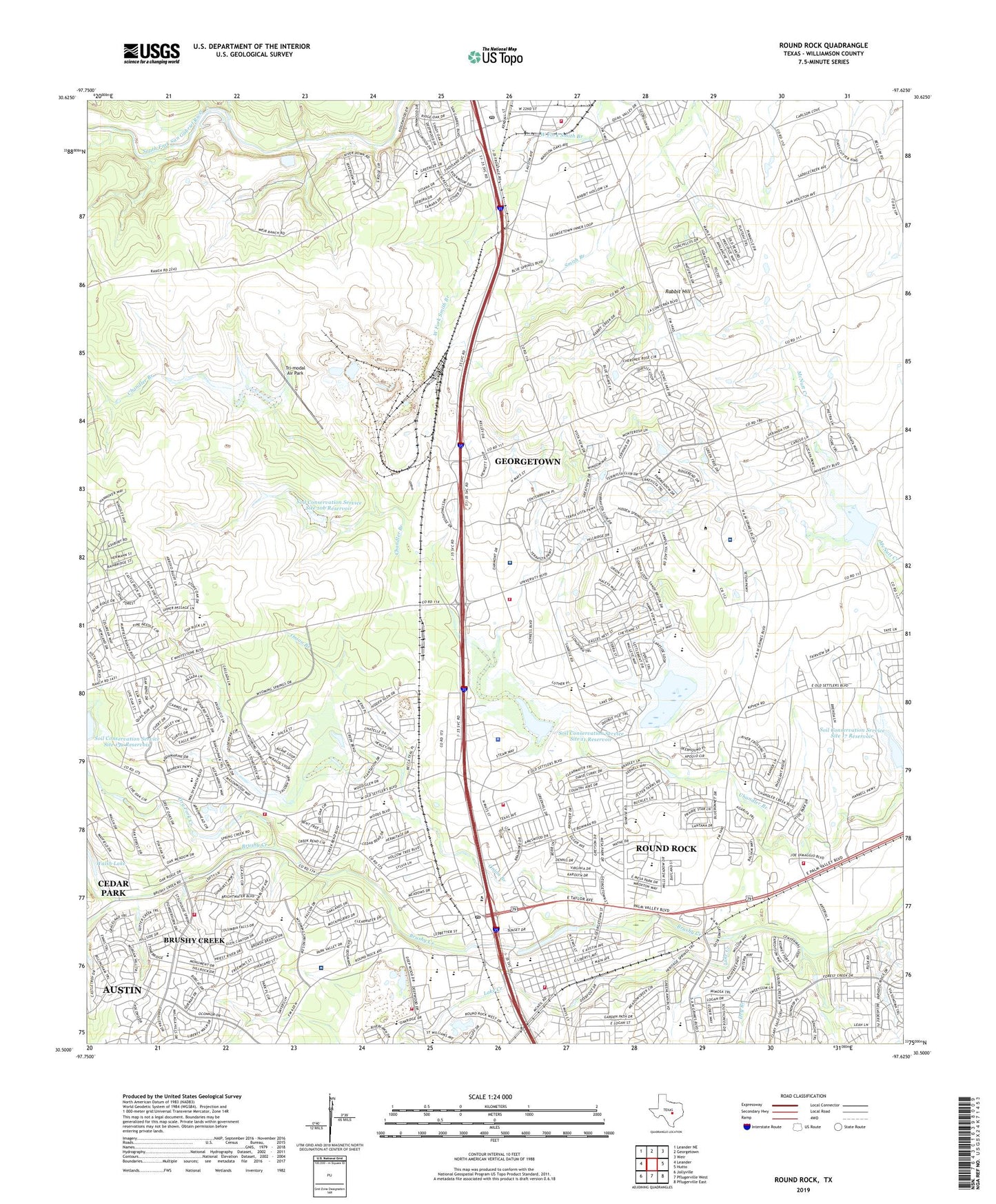
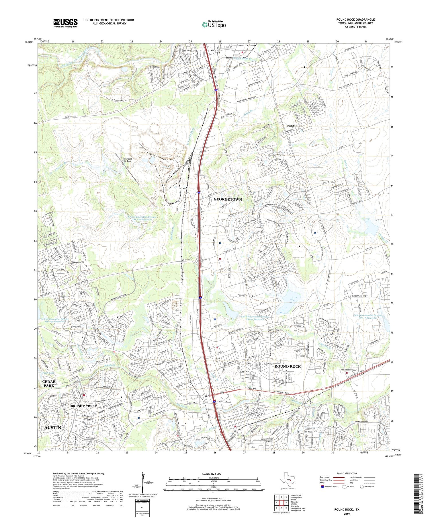
2019 topographic map quadrangle Round Rock in the state of Texas. Scale: 1:24000. Based on the newly updated USGS 7.5' US Topo map series, this map is in the following counties: Williamson. The map contains contour data, water features, and other items you are used to seeing on USGS maps, but also has updated roads and other features. This is the next generation of topographic maps. Printed on high-quality waterproof paper with UV fade-resistant inks.
Quads adjacent to this one:
West: Leander
Northwest: Leander NE
North: Georgetown
Northeast: Weir
East: Hutto
Southeast: Pflugerville East
South: Pflugerville West
Southwest: Jollyville
Contains the following named places: Ascension Seton Williamson, Baylor Scott and White Medical Center Round Rock, Bell School, Berkman Arts Integration Academy, Brushy Creek, Brushy Creek Census Designated Place, Brushy Creek Elementary School, Bustin Memorial Park, C D Fulkes Middle School, Captain Nelson Merrell House, Chisholm Trail Middle School, City of Round Rock, Crossroads Chapel Church, Deep Wood Elementary School, Dell Diamond, Dell Pickett Elementary School, Double File Trail Elementary School, Dragon Stadium, Dry Branch, Dry Fork Creek, Dyer Branch, Egger Park, Faith Community Baptist Church, Faith Missionary Baptist Church, Fern Bluff Elementary School, First Baptist Church of Round Rock, First United Methodist Church of Round Rock, Georgetown Fire Department Station 1, Georgetown Post Office, Grace Lutheran Church, Grace Temple Pentecostal Church of God, Green Airport, Hopewell Middle School, Inn at Brushy Creek, J J Johnson Farm, James Tippit Middle School, KNLE-FM (Round Rock), Lake Creek, Lake Creek Park, Mesa Village Park, Oakwood Surgery Center, Old Round Rock, Old Settlers Park, Old Town Elementary School, Onion Branch, Paige-DeCrow-Weir House, Palm Valley Church, Primera Iglesia Bautista of Round Rock Church, Rabbit Hill, Robertson Elementary School, Rock Creek Plaza Shopping Center, Round Rock, Round Rock Chapel Church, Round Rock Church of Christ, Round Rock City Hall, Round Rock Commercial Historic District, Round Rock Community Church, Round Rock Fire Department Central Station, Round Rock Fire Department Station 2, Round Rock Fire Department Station 5, Round Rock Fire Department Station 6, Round Rock Fire Department Station 7, Round Rock High School, Round Rock High School Softball Field, Round Rock Police Department, Round Rock Presbyterian Church, Round Rock West Post Office, Round Rock West Shopping Center, Round Rock-Georgetown Division, Roundrock West Park, Saint Andrews Anglican Church, Saint David's Round Rock Medical Center, Saint John Vianney Catholic Church, Saint Pauls African Methodist Episcopal Church, Sam Bass Fire Department Station 1, Seventh Day Adventist Church, Soil Conservation Service Site 10a Dam, Soil Conservation Service Site 10a Reservoir, Soil Conservation Service Site 10b Dam, Soil Conservation Service Site 10b Reservoir, Soil Conservation Service Site 11 Dam, Soil Conservation Service Site 11 Reservoir, Soil Conservation Service Site 12 Dam, Soil Conservation Service Site 12 Reservoir, Soil Conservation Service Site 14 Dam, Soil Conservation Service Site 14 Reservoir, Soil Conservation Service Site 16 Dam, Soil Conservation Service Site 16 Reservoir, Soil Conservation Service Site 17 Dam, Soil Conservation Service Site 17 Reservoir, South Brushy Creek, Stark Park, Stella Park, Stony Point Ninth Grade Campus, Sweethome Baptist Church Round Rock, The Church of Jesus Christ of Latter Day Saints, The Market at Round Rock, Tri-modal Air Park, Trinity Lutheran Church, Union Hill Elementary School, Walsh Lake Dam, Williamson County Constable's Office Precinct 1, Williamson County Constable's Office Precinct 3, Williamson County Emergency Medical Services Round Rock, ZIP Codes: 78664, 78665, 78681