MyTopo
Southton Texas US Topo Map
Couldn't load pickup availability
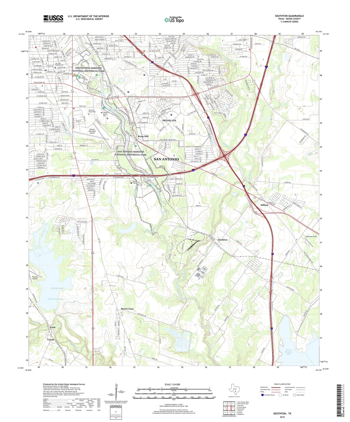
2019 topographic map quadrangle Southton in the state of Texas. Scale: 1:24000. Based on the newly updated USGS 7.5' US Topo map series, this map is in the following counties: Bexar. The map contains contour data, water features, and other items you are used to seeing on USGS maps, but also has updated roads and other features. This is the next generation of topographic maps. Printed on high-quality waterproof paper with UV fade-resistant inks.
Quads adjacent to this one:
West: Terrell Wells
Northwest: San Antonio West
North: San Antonio East
Northeast: Martinez
East: Elmendorf
Southeast: Saspamco
South: Losoya
Southwest: Thelma
Contains the following named places: Ashley Road Baptist Church, Ball School, Believers Baptist Church, Bellaire Park, Bergs Mill, Bexar County Learning Center, Blue Wing Lake, Blue Wing Lake Dam, Braunig Park, Brookhill Baptist Church, Brooks Air Force Base, Brooks Park, Brown Park, Buena Vista, Cassin, Cassin Lake, Cassin Lake Dam, Cassin Siding, Charles C Ball Elementary School, Church of Christ Pecan Valley, Church of God of Denver Heights, Connell Junior High School, Connell Middle School, Crestholme Presbyterian Church, Department of Public Safety Heliport, E H Gilbert Elementary School, Earle, Eckert Oil Field, Epworth United Methodist Church, Espada Aqueduct, Espada Dam, Espada Ditch, Espada Park, Faith Gospel Fellowship Church, First United Pentecostal Church, Forbes School, Foster Elementary School, Foster School, Frank M Tejeda Academy, Frank M. Tejada Academy, Glory Land Revival Center Church, Good Shepherd Lutheran Church, Hangar 9 Museum, Harlandale Baptist Church, Harlandale Christian Church, Harlandale Church of Christ, Harlandale Creek, Harlandale Memorial Stadium, Harlandale Middle School, Harlandale Multi-Handicapped Center, Harlandale Park, Harlandale Post Office, Harlandale School, Harlandale United Methodist Church, Harmony Elementary School, Harmony Field, Harmony School, Highland Hills Seventh Day Adventist Church, Hilltop, Holy Cross Episcopal Church, Holy Name Catholic Church, Holy Name School, Homer W. Schulze Elementary School, Hope Presbyterian Church, Horizon Airport, Hot Wells Baptist Church, Iglesia Pentecostal Unida Hispana Church, J F Kennedy Memorial, Jewel C Wietzel Center, Kid Kountry Early Learning Center, Kingborough Middle School, Kingdom Hall of Jehovahs Witnesses, Kingsborough Church, Kingsborough Middle School, Kingsborough Park, Leon Creek, Maranatha Adventist School, March Avenue Baptist Church, Med Care Ambulance, Minita Creek, Mission Burial Park, Mission County Park, Mission el Jordan, Mission Espada, Mission Espada Cemetery, Mission Park, Mission Parkway, Mission Road Foundation School, Mission San Francisco de la Espada, Mission San Juan Capistrano, Mission San Juan de Capistrano, Mission Trail Baptist Hospital, Mitchell Lake, Mitchell Lake Dam, Mitchell Lake Spring, Morrill Elementary School, Multi Handicapped Center, Muriel Forbes Elementary School, New Espada Lake, New Espada Lake Dam, New Testament Christian Church, Omega Academic Center, Omega Church, Open Arms Ministries, Padre Park, Pecan Valley Elementary School, Pecan Valley Golf Course, Pickwell Park, Positive Solutions School, Pyron Avenue Baptist Church, Pytel Park, Ravenhill Baptist Church, Rio Medina Airport, Rock of Revelation Church, Rodgers Junior High School, Rogers Middle School, Rosillo Creek, Saint Frances Cabrini Church, Saint Lawrence School, Salado Creek, Salado Creek Water Resources Complex, Salado Intermediate School, Salado School, San Antonio Can High School, San Antonio Fire Department Station 20, San Antonio Fire Department Station 21, San Antonio Fire Department Station 22, San Antonio Fire Department Station 29, San Antonio Missions National Historical Park, San Antonio Police Academy, San Antonio State Hospital, San Antonio Street School, San Francisco de Las Espada Mission, San Jose Burial Park, San Jose Church, San Jose Mission, San Jose Mission Cemetery, San Jose School, San Juan Ditch, Scheh Center, Schenck Elementary School, Schenck School, Seidel Learning Center, Siedel Learning Center, Sixmile Creek, South Memorial Christian Church, Southeast Assembly of God Church, Southeast Baptist Hospital, Southside Church of God, Southton, Southton Oil Field, Southton Sanitorium, Spiritual Church of the Open Door, Stinson Municipal Airport, Stinson Park, Templo Puerta del Cielo New Jerusalem, Texas Center for Infectious Disease Hospital, Texas Highway Patrol Office - San Antonio, The Church of Jesus Christ of Latter Day Saints, Trinity Lutheran Church, Triumph Christian Center, V H Braunig Von Rosenberg Power Plant, Ven A El Iglesia Bautista Church, Villa Coronado Park, Ward School, Words of Life Apostolic Church, Wright Elementary School, Wright School, ZIP Codes: 78214, 78221, 78223, 78235