MyTopo
Fort Douglas Utah US Topo Map
Couldn't load pickup availability
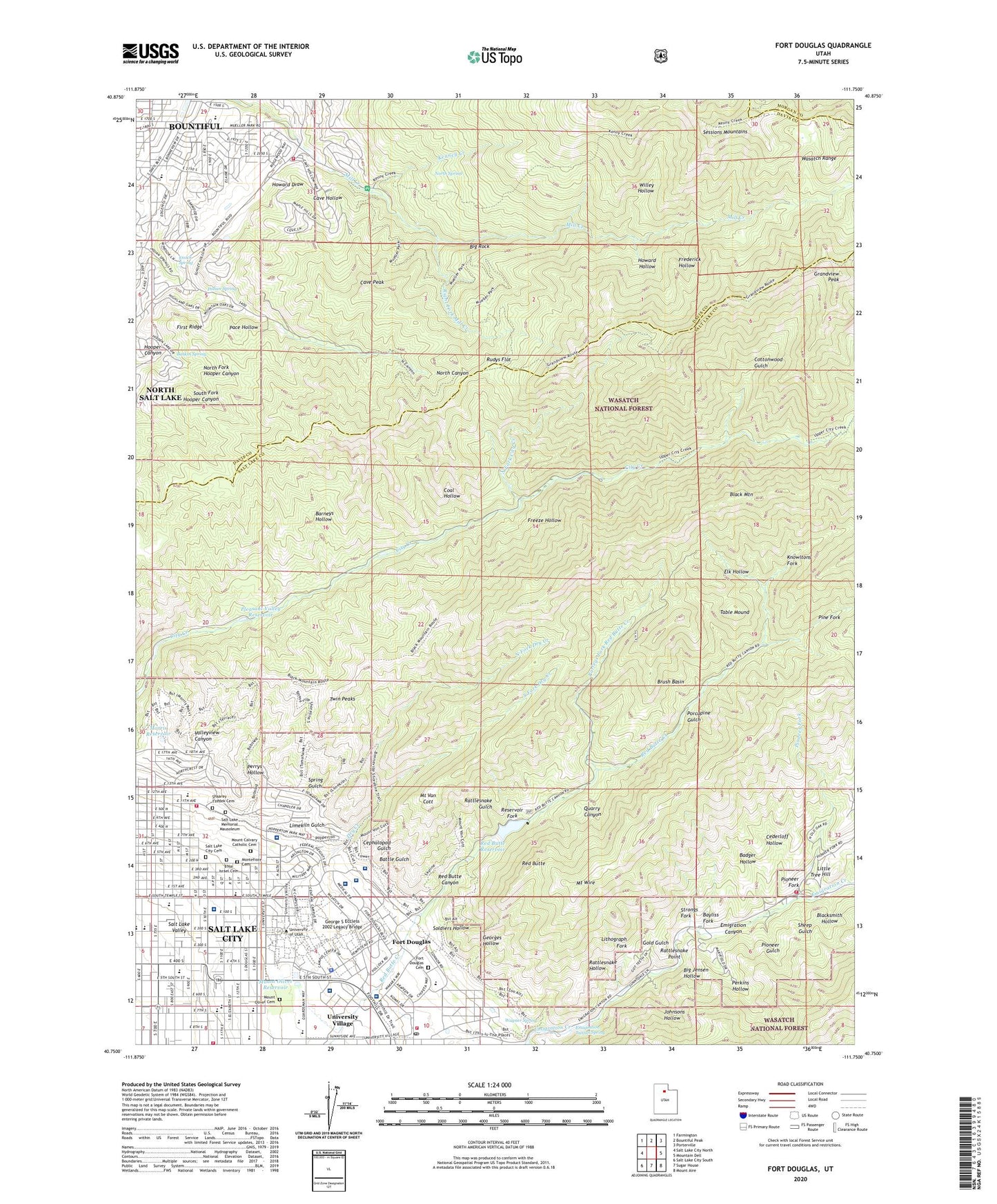
2020 topographic map quadrangle Fort Douglas in the state of Utah. Scale: 1:24000. Based on the newly updated USGS 7.5' US Topo map series, this map is in the following counties: Salt Lake, Davis, Morgan. The map contains contour data, water features, and other items you are used to seeing on USGS maps, but also has updated roads and other features. This is the next generation of topographic maps. Printed on high-quality waterproof paper with UV fade-resistant inks.
Quads adjacent to this one:
West: Salt Lake City North
Northwest: Farmington
North: Bountiful Peak
Northeast: Porterville
East: Mountain Dell
Southeast: Mount Aire
South: Sugar House
Southwest: Salt Lake City South
Contains the following named places: Alfred Emery Building, Alien Wilmont Skaggs Biology Residence Building, Arlington Hills, Arlington Park, Badger Hollow, Barneys Hollow, Baskin Spring, Battle Gulch, Bayliss Fork, Bennion Elementary School, Big Jensen Hollow, Big Rock, Black Mountain, Blacksmith Hollow, B'Nai Israel Cemetery, Bonneville on the Hill, Browns Park, Brush Basin, Bryant Middle School, Burro Mine, C Ronald Christensen Center, Cancer Wellness House, Capitol Heights, Capitol Hill, Carlson Hall, Casa de Norte, Cave Hollow, Cave Peak, Cederloff Hollow, Cephalopod Gulch, Chase M Peterson Heritage House, Chelsea Cove, City of Bountiful, Coal Hollow, Cookes, Cottonwood Gulch, Country Hills, David P Garner Hall, Diabetes Treatment Center at Holy Cross Hospital, Dry Creek, Dunfords, E E Jones Medical Science Building, East High School, Eccles Broadcast Center, Eccles Health Sciences Education Building, Eccles Institute of Human Genetics, Eliner Nielsen Fieldhouse, Elk Hollow, Ellison Place, Emerald Hills, Emigration Canyon, Emigration Oaks, Emigration Tunnel Spring, Enoch Spring, Ensign Elementary School, Ezekiel R and Edna Dumke Building, Federal-Heights, First Ridge, Foothill Post Office, Fort Douglas, Fort Douglas Cemetery, Francis Armstrong Madsen Building, Fraternity Park, Frederick Hollow, Freeze Hollow, George E Wahlen Department of Veterans Affairs Medical Center, George S Eccless 2002 Legacy Bridge, George S-Delores D Eccles Critical Care Pavilion, George Thomas Museum of Natural History, Georges Hollow, Gold Gulch, Golf Course Estates, Grand View, Grandview Peak, Hamilton School, Henry Eryring Building, High Pointe, Holy Cross Hospital Helipad, Hospital Klean of Texas, Howard Draw, Howard Hollow, Huntsman Cancer Hospital, Indian Spring, Indian Springs Estates, Intermountain Network Scientific Center, J T Kingsbury Hall, James Fletcher Hall, James Taimage Building, John A Moran Eye Center, John A Moran Eye Center 2, John and Marva Warnock Engineering Building, John R Park Building, John Widtson Building, Johnsons Hollow, Jon M Huntsman Center, Joseph Merrill Engineering Building, Judge Memorial Catholic High School, Kendall D Garff Building, Kennecott Building, Kennecott House, Kenney Creek, Kindercare Learning Centers of Salt Lake City, Knowltons Fork, L S Skaggs Pharmacy Building, Leroy Cowels Building, Limekiln Gulch, Lindsey Gardens, Lithograph Fork, Little Tree Hill, Longfellow School, M Lynn Bennion Elementary School, Madsen Health Center, Maple Cove, Maple Hills, Maple Springs, Marcia and John Price Museum, Marriott Center for Dance, Marriott Library, Maxwell Wintrobe Research Building, Milton Bennion Hall, Montefiore Cemetery, Montessori School, Morris Reservoir, Mount Calvary Catholic Cemetery, Mount Olivet Cemetery, Mount Olivet Reservoir, Mount Van Cott, Mount Wire, Mueller Heights, Mueller Panc Forest Service Station, Mueller Park Junior High School, Mueller Park Recreation Site, Muir Elementary School, Muller Park, Nelson, Newport Heights, Nobhill, North Bonneville, North Canyon Estates, North Fork City Creek, North Fork Dry Creek, North Fork Hooper Canyon, North Hills, North Spring, Northcrest, Oak Hills, Oak Way, Oakcrest, Oakhaven Park, Oakhaven Village, Oakridge Manor, Oakvista Park, Orchard Park, Our Lady of Lourdes Catholic School, Pace Hollow, Panorama Acres, Paradise Hills, Parleys Fork Red Butte Creek, Perkins Hollow, Perrys Hollow, Pine Fork, Pioneer Fork, Pioneer Gulch, Pioneer Monument State Park, Pleasant Valley Reservoir, Popperton Place, Porcupine Gulch, Pratts, Primary Children's Medical Center, Quad, Quarry Canyon, Rattlesnake Gulch, Rattlesnake Hollow, Rattlesnake Point, Red Butte, Red Butte Canyon, Red Butte Canyon Research Natural Area, Red Butte Dam, Red Butte Reservoir, Reservoir Fork, Rice-Eccles Stadium, Right Fork Mill Creek, Roosevelt Junior High School, Rose Garden, Rotary Park, Rowland Hall-Saint Marks Middle School, Rudys Flat, Saint Pauls Christian Preschool, Salt Lake City Cemetery, Salt Lake Memorial Mausoleum, Salt Lake Regional Medical Center, Salt Lake Theological Seminary, San Simeon Hills, Sessions Mountains, Seventh East Shopping Center, Shaarey Tzedek Cemetery, Sheep Gulch, Shriners Hospital for Children, Soldiers Hollow, South Fork Dry Creek, South Fork Hooper Canyon, Spring Glen, Spring Gulch, Strongs Fork, Sunnyside Park, Sunset Hollow, Table Mound, The Joanne and Richard McGillis School, Thirteenth Avenue, This is the Place Monument, Treasure Box Mine, Trolley Square, Twin Peaks, United States Forest Service Airport, University Health Care Center, University Neuropsychiatric Institute, University of Utah, University of Utah Hospital, University of Utah Medical Center Heliport, University of Utah Psychoeducational Clinic, University Orthopaedic Center, University Village, Valleyview Canyon, Veterans Administration Hospital Heliport, Victoria Place, Virginia Heights, Wagner Spring, Wasatch Elementary School, Willey Hollow, Woodmansee, ZIP Codes: 84010, 84102, 84103, 84112, 84113