MyTopo
Bountiful Peak Utah US Topo Map
Couldn't load pickup availability
Also explore the Bountiful Peak Forest Service Topo of this same quad for updated USFS data
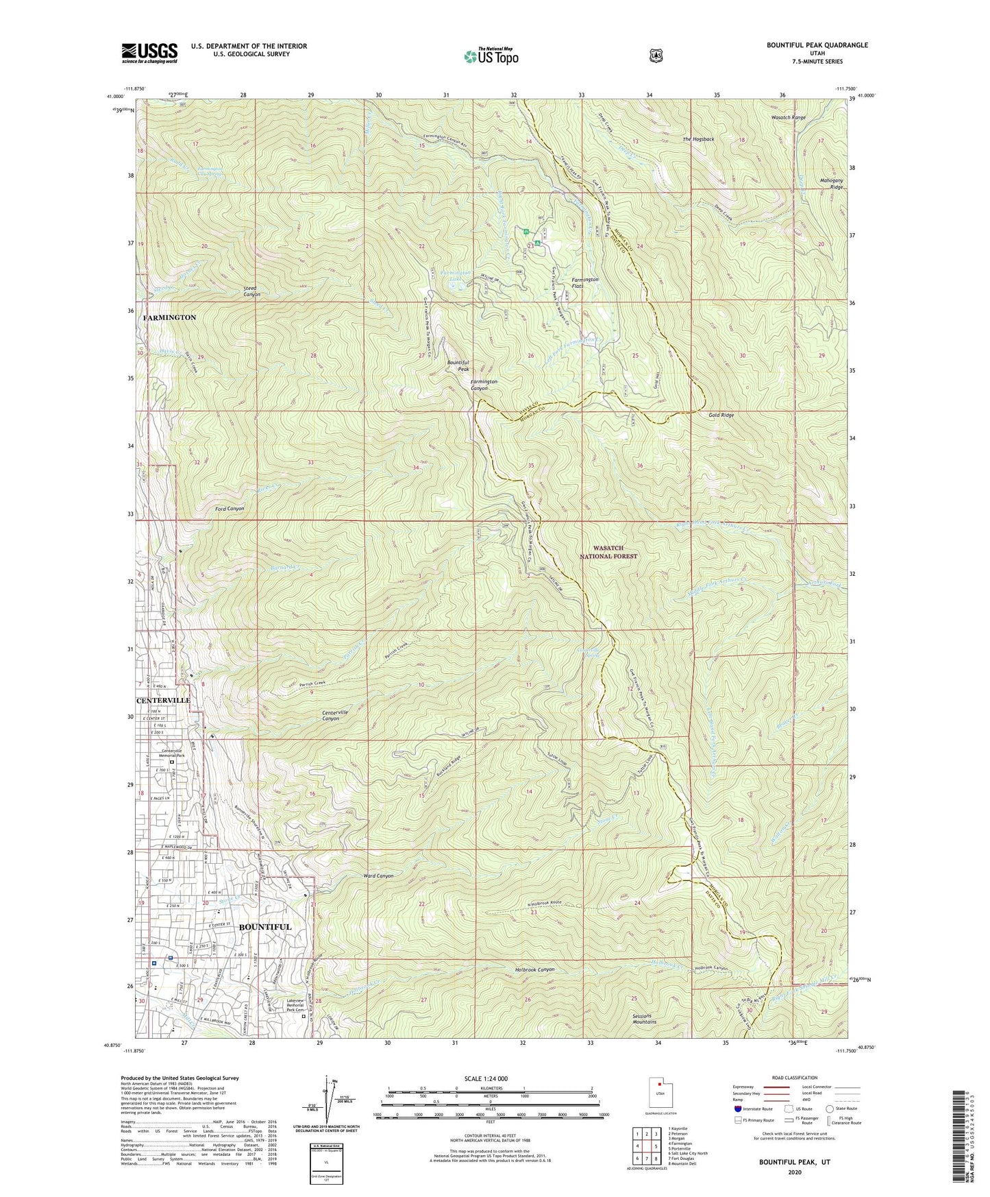
2023 topographic map quadrangle Bountiful Peak in the state of Utah. Scale: 1:24000. Based on the newly updated USGS 7.5' US Topo map series, this map is in the following counties: Davis, Morgan. The map contains contour data, water features, and other items you are used to seeing on USGS maps, but also has updated roads and other features. This is the next generation of topographic maps. Printed on high-quality waterproof paper with UV fade-resistant inks.
Quads adjacent to this one:
West: Farmington
Northwest: Kaysville
North: Peterson
Northeast: Morgan
East: Porterville
Southeast: Mountain Dell
South: Fort Douglas
Southwest: Salt Lake City North
This map covers the same area as the classic USGS quad with code o40111h7.
Contains the following named places: Alta Heights, Amby Briggs, B and B, Bali Hai, Barlow, Bountiful Community Church, Bountiful Heights, Bountiful High School, Bountiful Hills Estates, Bountiful Peak, Bountiful Peak Campground, Bountiful Peak Overlook, Bountiful Peak Summer Home Area, Brentwood Estates, Brentwood Hills, Briggs, Buckland Flat Recreation Site, Burningham, Cannon Hills, Canyon Crest, Canyon Rim, Centerville, Centerville Acres, Centerville Canyon, Centerville Canyon Overlook, Centerville Memorial Park, Centerville Spring, Central Heights, Chandler, Cherry Circle, Chicken Creek, Cinnamon Ridge, Circle View Heights, Colonial Heights, Cottonwood Acres, Cottonwood Heights, Crestwood, Deuel Creek Heights, Eastwood Park, Eggett Estates, Ellis Park, Ern Hayes, Ezra Clark, Farmington Canyon, Farmington City Springs, Farmington Creek Research Center, Farmington Flats, Farmington Guard Station, Farmington Lake, Florece, Foothill Acres, Ford Canyon, Forest Park, Freestone Acres, Gale, Glen Oaks, Gold Ridge, Granada Hills, Hell Hole Creek, Hillcrest, Hillsdale, Hillside, Hilltop, Hilltop Gardens, Holbrook Canyon, Holbrook Elementary School, Holbrook Heights, Holmes Estates, Hornet Creek, Horsely Circle, Howard Estates, Island View, Jensen, Lago Vista Circle, Lakeview Hospital, Lakeview Hospital Heliport, Lakeview Memorial Park Cemetery, Lakeview Terrace, Larsen Heights, Left Fork Farmington Creek, Left Hand Fork Arthurs Creek, Major, Maple Crest, Maple Glen, Marlow, Middle Fork Arthurs Creek, Millcreek Junior High School, Miller Creek, Moss Hill Drive, Mount Lebannon Acres, Mount View, Mountain Park, Mud Creek, North Hillsdale, North Park, Northern Hills, Oak Hills Elementary School, Orchard Heights, Orchard View, Packlynn, Panorama, Parrish Creek, Parrish Creek Research Center, Pheasantridge Estates, Quailbrook, Randall Way, Reed, Rice Creek, Right Fork Farmington Creek, Right Hand Fork Arthurs Creek, Rockwood Estates, Rockwood Gardens, Sheridan, Smith, South Davis Community Hospital, Steed Canyon, Steed Creek Overlook, Summers, Sunset Heights, Ten Fifty East Circle, The Church of Jesus Christ of Latter Day Saints, Twin Hollows, Val Mar, Valley View Elementary School, Valley View Heights, Van Fleet Creek, Van Orden Heights, Vineyard, Vistaview, Ward Canyon, Ward Canyon Overlook, Whipple Creek, Woodland, Woodland Hills Estates, Woodmere