
MyTopo
Mirror Lake Utah US Topo Map
Couldn't load pickup availability
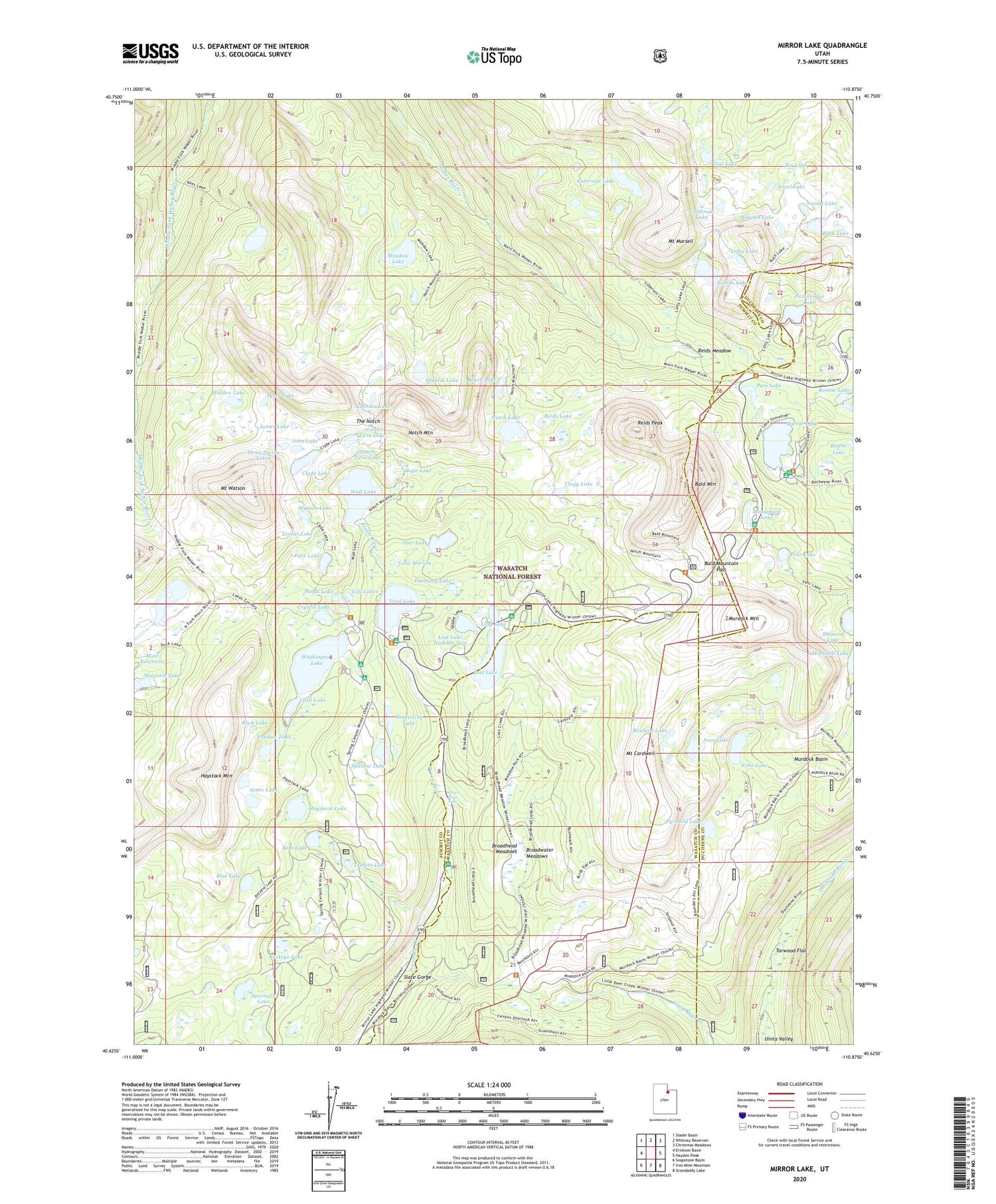
2020 topographic map quadrangle Mirror Lake in the state of Utah. Scale: 1:24000. Based on the newly updated USGS 7.5' US Topo map series, this map is in the following counties: Summit, Duchesne, Wasatch. The map contains contour data, water features, and other items you are used to seeing on USGS maps, but also has updated roads and other features. This is the next generation of topographic maps. Printed on high-quality waterproof paper with UV fade-resistant inks.
Quads adjacent to this one:
West: Erickson Basin
Northwest: Slader Basin
North: Whitney Reservoir
Northeast: Christmas Meadows
East: Hayden Peak
Southeast: Grandaddy Lake
South: Iron Mine Mountain
Southwest: Soapstone Basin
Contains the following named places: Abes Lake, Abes Lake Dam, Azure Lake, Bald Mountain, Bald Mountain Campground, Bald Mountain Overlook, Bald Mountain Pass, Bald Mountain Trailhead Picnic Area, Bench Lake, Beth Lake, Blizzard Lake, Blue Lake, Bonnie Lake, Booker Lake, Broadhead Meadows, Broadwater Meadows, Buckeye Lake, Camp Steiner, Castle Lake, Clegg Lake, Cliff Lake, Cliff Lake Dam, Clyde Lake, Crystal Lake, Crystal Lake Trail Head, Cuberant Lake, Cutthroat Lake, Dean Lake, Diamond Lake, Echo Lake, Emerald Lake, Fehr Lake, Fir Lake, Gem Lake, Hayden Lake, Haystack Lake, Haystack Mountain, Hidden Lake, Hope Lake, Ibantik Dam, Ibantik Lake, James Lake, Jewel Lake, Joan Lake, John Lake, Kamas Lake, Kamas Lake Dam, Lake Marion, Liberty Lake, Lilly Lake, Lilly Lake Campground, Lily Lakes, Linear Lake, Lofty Lake, Lofty Lake Trail, Long Lake, Long Lake Dam, Lost Creek, Lost Creek Campground, Lost Lake, Lost Lake Dam, Lost Lake Number Two, Lost Lake Number Two Dam, Lovenia Lake, Marjorie Lake, Marjorie Lake Dam, Meadow Lake, Mirror Lake, Mirror Lake Campground, Mirror Lake Guard Station, Mirror Lake Recreation Site, Moosehorn Campground, Moosehorn Lake, Mount Cardwell, Mount Marsell, Mount Watson, Murdock Basin, Murdock Mountain, Naomi Lake, North Twin Lake, Notch Lake, Notch Mountain, Notch Mountain Trail, Pass Lake, Pass Lake Trailhead, Pearl Lake, Peter Lake, Petit Lake, Picturesque Lake, Ponds Lake, Provo River Falls, Provo River Falls Overlook, Pyramid Lake, Reids Lake, Reids Meadow, Reids Peak, Rock Lake, Ruth Lake, Scout Lake, Seymour Meadow Lake Dam, Shadow Lake, Shallow Lake, Shepard Lake, Shoestring Lake, Slate Gorge, Slate Gorge Overlook, South Twin Lake, Spectacle Lake, Star Lake, Star Lake Dam, Tadpole Lake, Tail Lake, Tarwood Flat, Teal Lake, The Notch, Three Divide Lakes, Trial Lake, Trial Lake Campground, Trial Lake Dam, Trident Lake, Twin Lakes, Upper Provo Bridge Picnic Area, Wall Lake, Wall Lake Dam, Washington Lake, Washington Lake Dam, Watson Lake, Weir Reservoir, Wilderness Area Overlook


