MyTopo
Chester Vermont US Topo Map
Couldn't load pickup availability
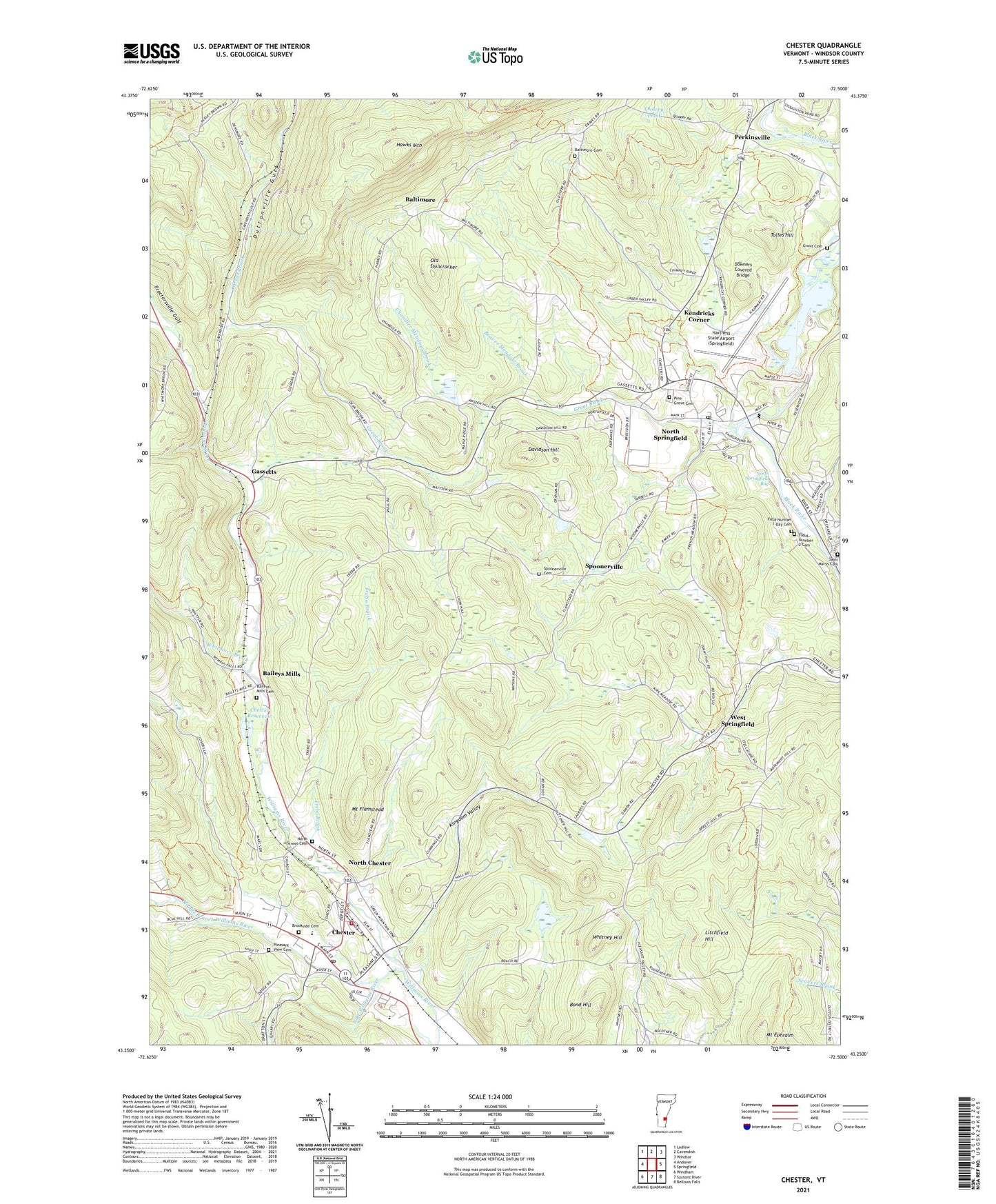
2021 topographic map quadrangle Chester in the state of Vermont. Scale: 1:24000. Based on the newly updated USGS 7.5' US Topo map series, this map is in the following counties: Windsor. The map contains contour data, water features, and other items you are used to seeing on USGS maps, but also has updated roads and other features. This is the next generation of topographic maps. Printed on high-quality waterproof paper with UV fade-resistant inks.
Quads adjacent to this one:
West: Andover
Northwest: Ludlow
North: Cavendish
Northeast: Windsor
East: Springfield
South: Saxtons River
Southwest: Windham
Contains the following named places: Advent Christian Church, Bailey Mills School, Baileys Mills, Baileys Mills Cemetery, Baltimore, Baltimore Cemetery, Baltimore School, Beaver Meadow Brook, Bond Hill, Brookside Cemetery, Chandler Meadow Brook, Chandler School, Chester, Chester - Andover Elementary School, Chester Census Designated Place, Chester Congregational Church, Chester Depot, Chester Fire Department, Chester Police Department, Chester Post Office, Chester Reservoir, Davidson Hill, Downers Covered Bridge, Duttonville Gulf, Field Number 1-Day Cemetery, Field Number 2 Cemetery, First Baptist Church, First Universalist Parish Church, Gassetts, Great Brook, Green Mountain Union High School, Grout Cemetery, Hartness State Airport (Springfield), Hawks Mountain, Hidden Valley Campground, Kendricks Corner, Kingdom Valley, Litchfield Hill, Middle Branch Williams River, Mount Ephraim, Mount Flamstead, North Chester, North Springfield, North Springfield Baptist Church, North Springfield Bog, North Springfield Census Designated Place, North Springfield Dam, North Springfield Industrial Park, North Springfield Lake Recreation Area, North Springfield Post Office, North Springfield Reservoir, North Street Cemetery, Old Shincracker, Perkinsville, Perkinsville Census Designated Place, Perkinsville Community Church, Pine Grove Cemetery, Pleasant Valley School, Pleasant View Cemetery, Proctorsville Gulf, Quarry Pond, Saint Josephs Church, Saint Marys Cemetery, South Branch Williams River, Spoonerville, Spoonerville Cemetery, Springfield Art and Historical Society Building, Springfield Art and Historical Society Library, Springfield Art and Historical Society Museum, Springfield Nature Area, Tolles Hill, Town of Baltimore, Town of Chester, Trebo Brook, Trebo School, Universalist Church, Village of Perkinsville, Weathersfield Elementary School, West Springfield, West Springfield School, Whitmore Brook, Whitney Hill, Windsor Southwest Supervisory Union, ZIP Code: 05150