MyTopo
Saxtons River Vermont US Topo Map
Couldn't load pickup availability
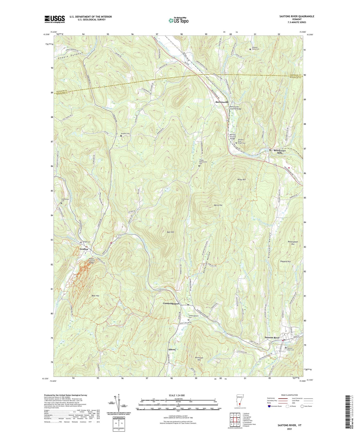
2024 topographic map quadrangle Saxtons River in the state of Vermont. Scale: 1:24000. Based on the newly updated USGS 7.5' US Topo map series, this map is in the following counties: Windham, Windsor. The map contains contour data, water features, and other items you are used to seeing on USGS maps, but also has updated roads and other features. This is the next generation of topographic maps. Printed on high-quality waterproof paper with UV fade-resistant inks.
Quads adjacent to this one:
West: Windham
Northwest: Andover
North: Chester
Northeast: Springfield
Southeast: Walpole
South: Westminster West
Southwest: Townshend
This map covers the same area as the classic USGS quad with code k43072b5.
Contains the following named places: Atcherson Hollow, Athens, Athens Elementary School, Barnes Brook, Bartonsville, Bartonsville Covered Bridge, Bear Hill, Beaver Dam Brook, Beaver Dam Hill, Berry Hill, Brockways Mills, Brockways Mills Brook, Bull Creek, Bull Hill, Burgess Cemetery, Cambridgeport, Cambridgeport Cemetery, Cambridgeport Post Office, Christ Church, Easton School, Grafton, Grafton Census Designated Place, Grafton Congregational Church and Chapel, Grafton Cross Country Ski Center, Grafton Elementary School, Grafton Fire Department, Grafton Historical Museum Library, Grafton Historical Society Museum, Grafton Post Office, Grafton Public Library, Guild Brook, Hall Brook, Hinkley Brook, Hitchcock Brook, Hitchcock Hill, John J Dorand State Forest, John J Dorano State Forest, Kidder Covered Bridge, Leach Brook, Lillie Brook, Middletown Cemetery, Old Brick Church, Petty Brook, Pleasant Valley, Pleasant Valley Brook, Pleasant Valley Cemetery, Popple Dungeon, Rockingham Fire Department, Rockingham Hill, Rockingham Town Forest, Saint Edmund of Canterbury Roman Catholic Church, Saxtons River, Saxtons River Cemetery, Saxtons River Elementary School, Saxtons River Falls, Saxtons River Historical Society Building, Saxtons River Montessori School, Saxtons River Post Office, Saxtons River Village Historic District, Saxtons River Volunteer Fire Department, Shepard Hill, Signal Hill Brook, Skunk Hollow Brook, Sokoki Falls, South Branch Saxtons River, Stearns Brook, Timbertrail Camp, Town of Grafton, Town of Rockingham, Vermont Academy, Village Cemetery, Village of Saxtons River, Warner Brook, Weaver Brook, Wiley Hill, William C Putnam State Forest, Williams River - Wright Cemetery, Windham Foundation, Worralls Covered Bridge, Wright - Bartonsville Cemetery, Wright Brook, ZIP Codes: 05141, 05154