MyTopo
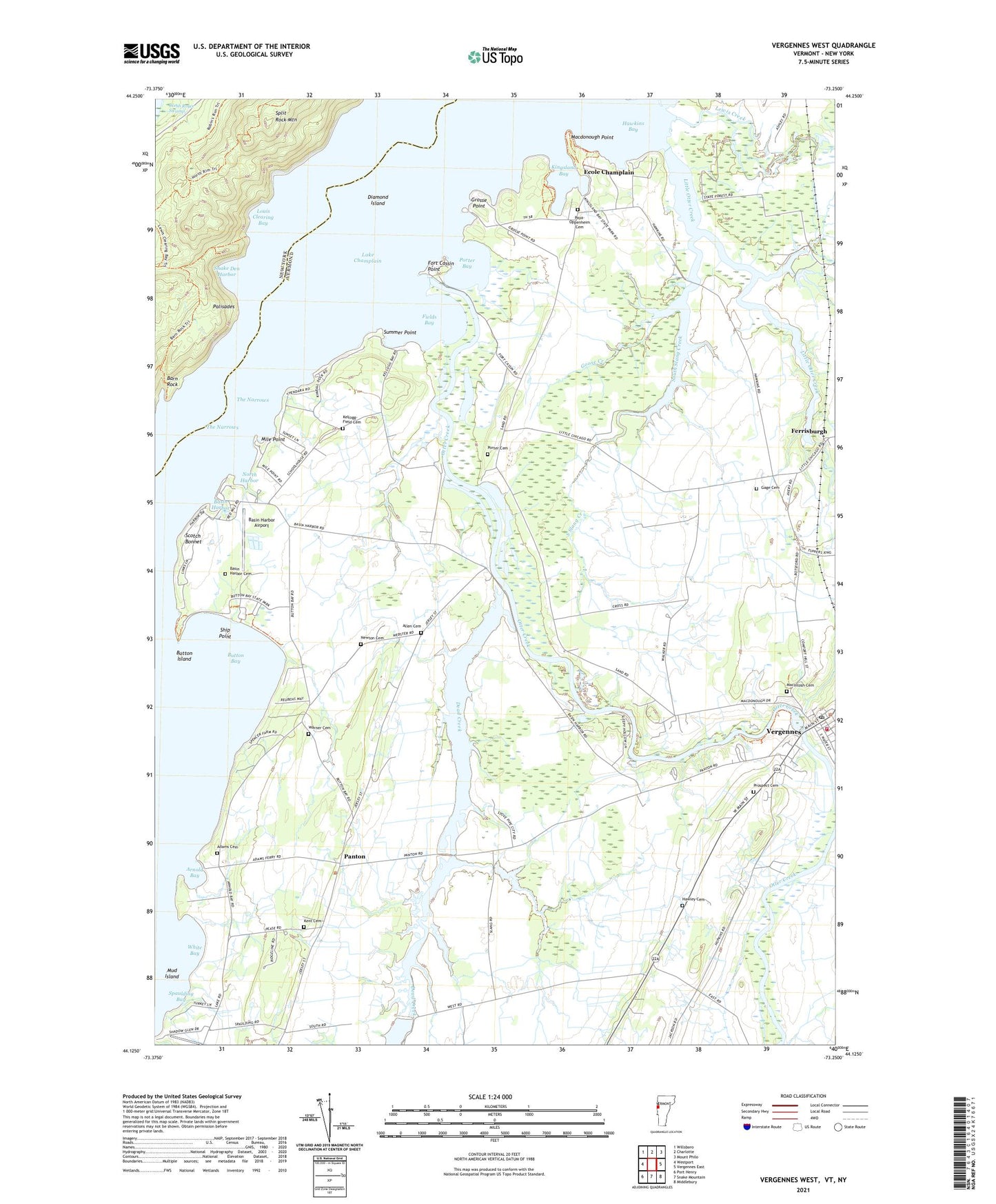
Vergennes West Vermont US Topo Map
Couldn't load pickup availability
2021 topographic map quadrangle Vergennes West in the states of Vermont, New York. Scale: 1:24000. Based on the newly updated USGS 7.5' US Topo map series, this map is in the following counties: Addison, Essex. The map contains contour data, water features, and other items you are used to seeing on USGS maps, but also has updated roads and other features. This is the next generation of topographic maps. Printed on high-quality waterproof paper with UV fade-resistant inks.
Quads adjacent to this one:
West: Westport
Northwest: Willsboro
North: Charlotte
Northeast: Mount Philo
East: Vergennes East
Southeast: Middlebury
South: Snake Mountain
Southwest: Port Henry
Contains the following named places: Adams Cemetery, Addison Gardens, Addison Northwest Supervisory Union, Allen Cemetery, Allendale Farm, Arnold Bay, Barn Rock, Barn Rock Bay, Basin Harbor, Basin Harbor Airport, Basin Harbor Cemetery, Basin Harbor Golf Course, Basin Harbor School, Bixby Memorial Free Library, Button Bay, Button Bay Nature Center, Button Bay State Park, Button Island, City of Vergennes, Crazy Acres Farm, Cub Field, Dead Creek, Dead Creek Wildlife Management Area, Diamond Island, East Panton School, East Slang Creek, Ecole Champlain, Essex Farm, Fields Bay, Fort Cassin Point, Fryslan Farm, Gage Cemetery, Gage School, Goose Creek, Grosse Point, Hatch Farm, Hawkins Bay, Hawley Cemetery, Holcomb Slang Creek, Kellogg-Field Cemetery, Kennland Farms, Kent Cemetery, Kings Bay State Park, Kingsland Bay, Lake Champlain Maritime Museum, Lewis Creek, Little Otter Creek, Little Otter Creek Wildlife Management Area, Louis Clearing Bay, Macdonough Point, MacIntosh Cemetery, Mile Point, Mud Island, Newton Cemetery, North Harbor, Otter Creek, Palisades, Panton, Panton Community Baptist Church, Pastureview Farm, Paya-Oppenheim Cemetery, Porter Bay, Porter Cemetery, Porterboro School, Prospect Cemetery, Rock Island, Rock Landing, Saint Peters Catholic Church, Sand Road School, Scotch Bonnet, Ship Point, Snake Den Harbor, South Slang Creek, Spaulding Bay, Split Rock Mountain, Stone Bridge Dam, Summer Point, Sunrise View Farm, The Narrows, Town of Ferrisburgh, Town of Panton, Vergennes, Vergennes Area Rescue Squad, Vergennes City Hall, Vergennes Congregational Church, Vergennes Opera House, Vergennes Police Department, Vergennes Post Office, Vergennes United Methodist Church, Vergennes Volunteer Fire Department, Vorsteveld Farm, Warner Cemetery, Webster School, West Panton School, Westport View Farm, White Bay, ZIP Code: 05456