MyTopo
Woodstock South Vermont US Topo Map
Couldn't load pickup availability
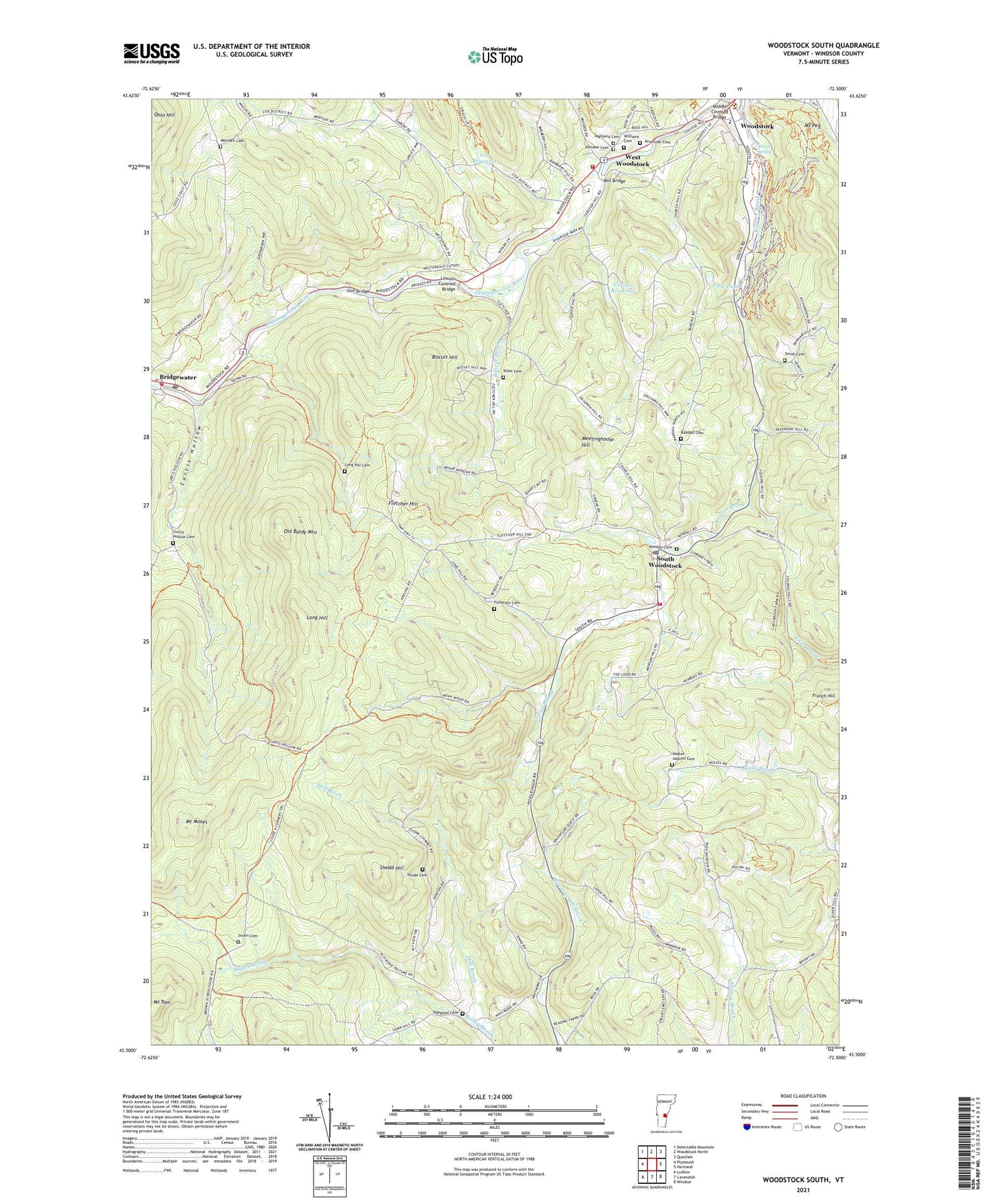
2021 topographic map quadrangle Woodstock South in the state of Vermont. Scale: 1:24000. Based on the newly updated USGS 7.5' US Topo map series, this map is in the following counties: Windsor. The map contains contour data, water features, and other items you are used to seeing on USGS maps, but also has updated roads and other features. This is the next generation of topographic maps. Printed on high-quality waterproof paper with UV fade-resistant inks.
Quads adjacent to this one:
West: Plymouth
Northwest: Delectable Mountain
North: Woodstock North
Northeast: Quechee
East: Hartland
Southeast: Windsor
South: Cavendish
Southwest: Ludlow
Contains the following named places: Bailey Brook, Bailey Mills, Beaver Brook, Biscuit Hill, Bridgewater Post Office, Bridgewater Village School, Bridgewater Volunteer Fire Department, Carlton Reservoir, Chase Corners, Cox District Reservoir Dam, Cox Reservoir, Curtis Hollow, Curtis Hollow Cemetery, Daughters of the American Revolution Historic House and Museum, Dreer Spring, Faulknet Park, First Church of Christ Scientist, Fletcher Hill, Fullerton Cemetery, Hapgood Cemetery, Hendee Cemetery, Highland Cemetery, Iron Bridge, Kendall Cemetery, Lincoln Covered Bridge, Little Theatre, Long Hill, Long Hill Cemetery, Meetinghouse Hill, Mendall Cemetery, Middle Covered Bridge, Mill Bridge, Mount Moses, Mount Peg, Mount Peg Foot and Bridal Trails, Norman Williams Public Library, North Chapel, Old Baldy Mountain, Our Lady of the Snows Roman Catholic Church, Randall Cemetery, Reading Center, Richardson Tavern, Riverside Cemetery, Saint James Episcopal Church, Shaw Cemetery, Shedd Cemetery, Shedd Hill, Smith Cemetery, South Woodstock, South Woodstock Census Designated Place, South Woodstock Historic District, South Woodstock Post Office, Southern Woodstock Fire Department, Swain Cemetery, The Green, The Market Place at Bridge Water Mill Shopping Center, Town of Woodstock, Townsend Corners, Vail Field, View Pond, Village of Woodstock, Walker-Jaquith Cemetery, West Woodstock, West Woodstock Census Designated Place, West Woodstock Dam, West Woodstock Fire Department, Williams Cemetery, Windsor Central Supervisory Union, Windsor County, Windsor County Courthouse, Woodstock, Woodstock Community Recreation Center, Woodstock Country Club and Ski Touring Center, Woodstock Elementary School, Woodstock Town Forest, Woodstock Town Hall, Woodstock Union High School, Woodstock Union Middle School, Woodstock Village Historic District, ZIP Code: 05071