MyTopo
Ashland Virginia US Topo Map
Couldn't load pickup availability
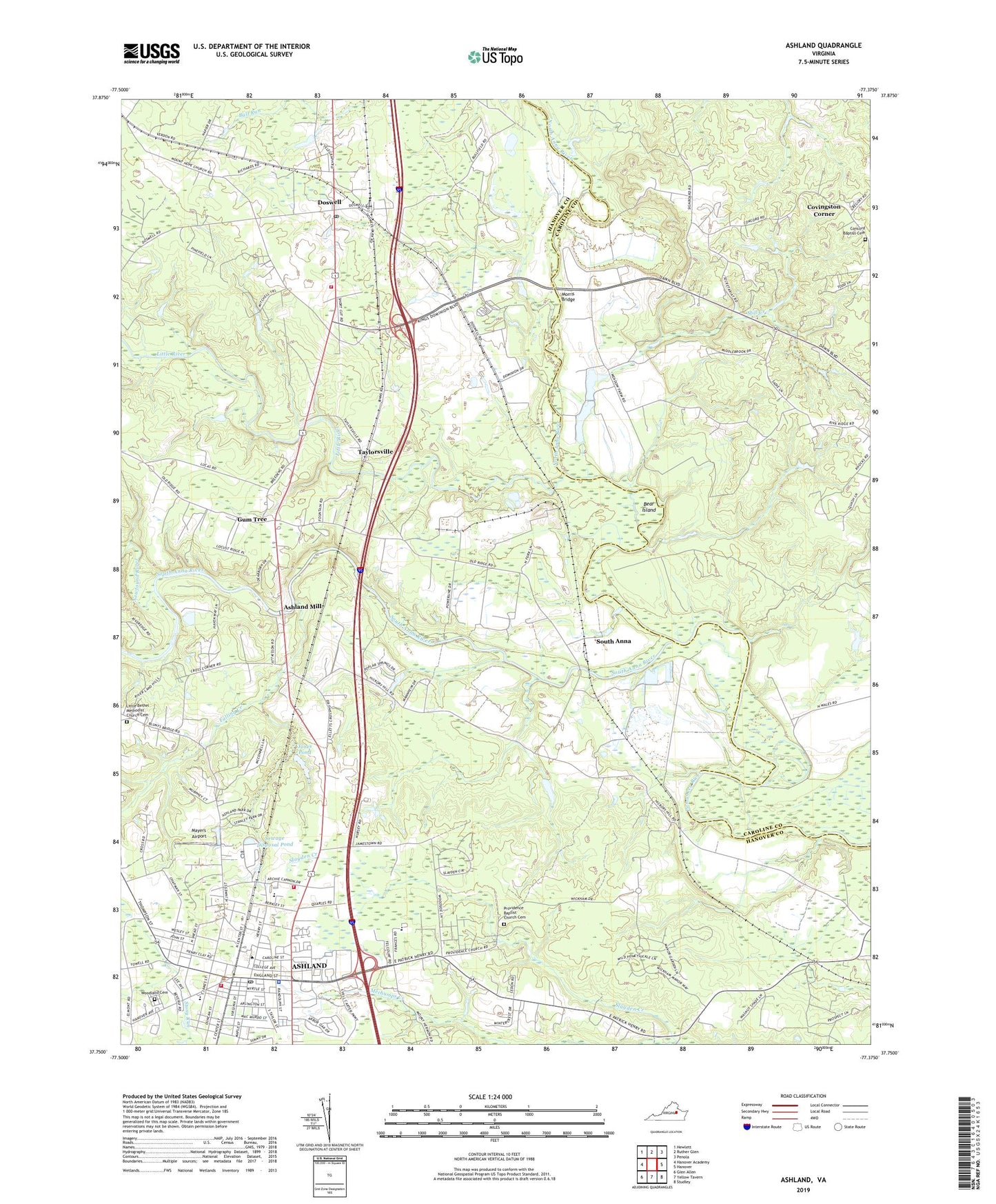
2019 topographic map quadrangle Ashland in the state of Virginia. Scale: 1:24000. Based on the newly updated USGS 7.5' US Topo map series, this map is in the following counties: Hanover, Caroline. The map contains contour data, water features, and other items you are used to seeing on USGS maps, but also has updated roads and other features. This is the next generation of topographic maps. Printed on high-quality waterproof paper with UV fade-resistant inks.
Quads adjacent to this one:
West: Hanover Academy
Northwest: Hewlett
North: Ruther Glen
Northeast: Penola
East: Hanover
Southeast: Studley
South: Yellow Tavern
Southwest: Glen Allen
Contains the following named places: Alpha Gamma Delta House, Ashland, Ashland Baptist Church, Ashland Church, Ashland Convalescent Center, Ashland Grammar School, Ashland Historic District, Ashland Junction Shopping Center, Ashland Mill, Ashland Municipal Building, Ashland Police Department, Ashland Post Office, Ashland Presbyterian Church, Ashland-Hanover Shopping Center, Bear Island, Bennett Residence Hall, Birdsong Townhouse, Blackwell Auditorium, Blackwell Auditorium and Cobb Theatre, Blackwell House, Blanton Crossing, Blincoe Field, Bowen Tennis Courts, Campbell Corner, Carters Ford, Clements Townhouse, Cochrane Townhouse, Concord Baptist Cemetery, Conrad Residence Hall, Copley Science Center, Covingston Corner, Crenshaw and Alumni Gymnasiums, DeJarnette Park, Delta Zeta House, Doswell, Doswell Post Office, Doswell School, Duncan Memorial Methodist Episcopal Church South, Elletts Crossing, Estes Dining Hall, Falling Creek, Flippo Townhouse, Frank E Brown Campus Center, Garland Residence Hall, Garnett Crossing, Gum Tree, Haley Hall, Hanover Academy, Hanover County, Hanover County Fire - EMS Company 1 - Ashland Volunteer Fire Station, Hanover County Fire - EMS Company 16 - Ashland Volunteer Rescue Squad, Hanover County Fire - EMS Company 4 - Doswell Volunteer Fire Station, Hart Corner, HealthSouth Medical Center, Henry Clay Elementary School, Henry Clay Shopping Center, Higgins Academic Center, Hugh Stephens Baseball Complex, Irby Residence Hall, Jerusalem Church, John M Gandy Elementary School, Jones Dam Number Two, Jones Pond, Jordan Wheat Lambert Historic Campus, Kappa Alpha House, Kappa Alpha Theta House, Kappa Sigma House, Keeble Observatory, Kings Dominion Amusement Park, Lambda Chi Alpha House, LEAPS Center, Little Bethel Methodist Church Cemetery, Little River, Little River Crossing, Mabry House, Mary Branch Residence Hall, Mayers Airport, McGraw - Page Library, McGraw-Page Library, Meadow Event Park, Meadow Farm Airport, Mill Creek, Moreland Residence Hall, Morris Bridge, Mount Hope Church, Neville House, Newfound River, North Anna River, North Ashland Plaza Shopping Center, Olin Residence Hall, Pace - Armistead Hall, Pamunkey Regional Library Richard S Gillis Jr Ashland Branch Library, Pannill House, Peele Hall Administration Building, Phi Delta Theta, Phi Mu House, President's House - Randolph-Macon College, Providence Baptist Church Cemetery, Providence Church, Ragland - Henry House, Randolph - Macon College, Rhodeen House, Saint Annes Roman Catholic Church, Saint Ann's Building, Sedgefield Mobile Home Park, Sewage Disposal Pond, Sewage Disposal Pond Dam, Shiloh Church, Sigma Alpha Epsilon House, Slayden Creek, South Anna, South Anna River, South Taylor Street Park, Starr Residence Hall, Taylor Street House, Taylorsville, Taylorsville Baptist Church, The Brock Center, Theresa A Thomas Medical Center, Theta Chi House, Thomas Branch Hall, Town of Ashland, Union Church, War Memorial Gymnasium, Washington and Franklin Hall, Weir Creek Emergency Services, Wickham Crossing, Wickham School, Woodland Cemetery, ZIP Codes: 23005, 23047