MyTopo
Bent Mountain Virginia US Topo Map
Couldn't load pickup availability
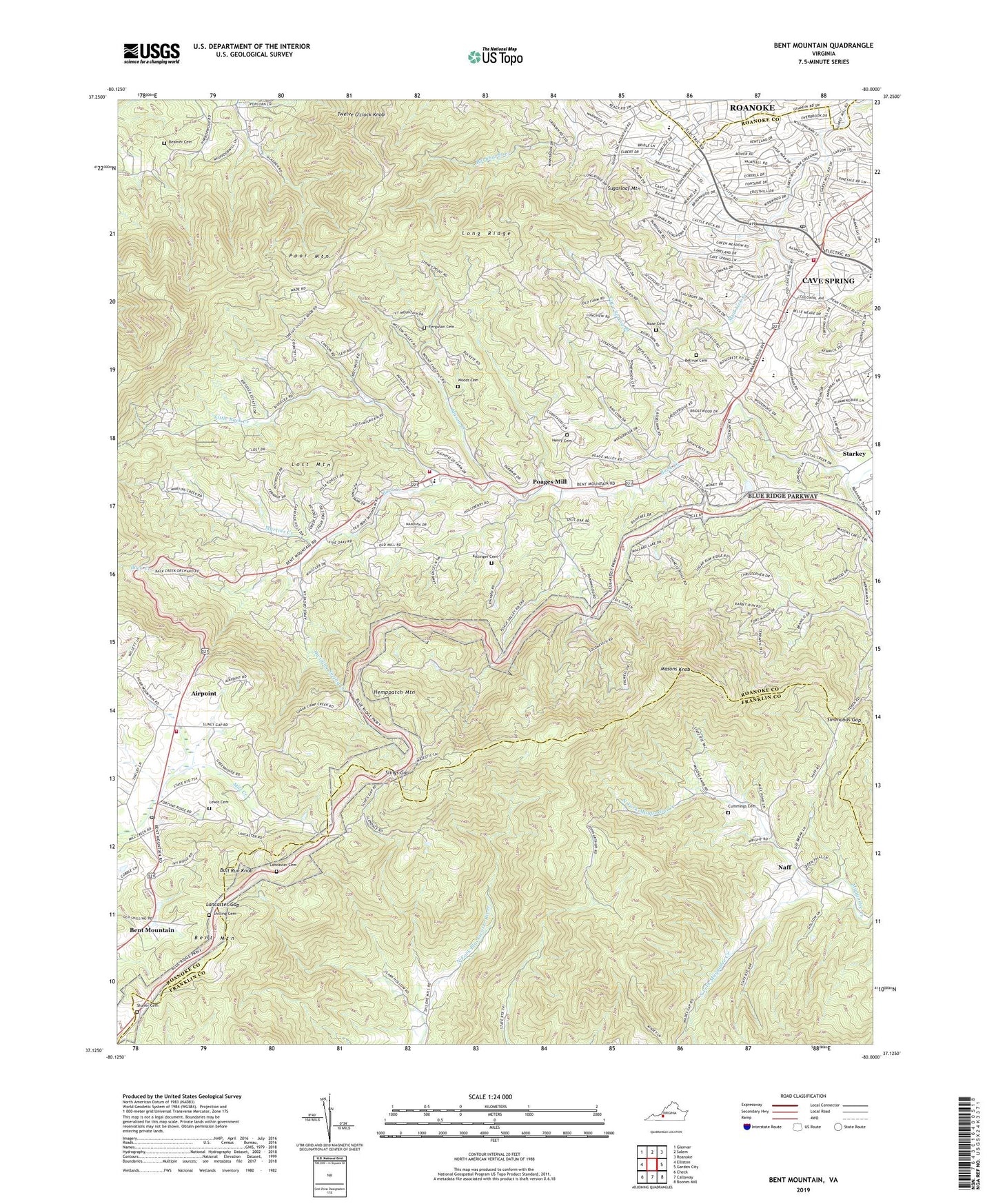
2019 topographic map quadrangle Bent Mountain in the state of Virginia. Scale: 1:24000. Based on the newly updated USGS 7.5' US Topo map series, this map is in the following counties: Roanoke, Franklin, Roanoke (city). The map contains contour data, water features, and other items you are used to seeing on USGS maps, but also has updated roads and other features. This is the next generation of topographic maps. Printed on high-quality waterproof paper with UV fade-resistant inks.
Quads adjacent to this one:
West: Elliston
Northwest: Glenvar
North: Salem
Northeast: Roanoke
East: Garden City
Southeast: Boones Mill
South: Callaway
Southwest: Check
Contains the following named places: Adam Acres, Airpoint, Airview Court, Arlington Forest, Arlington Hills, Arthurs Knob School, Back Creek Church, Back Creek Elementary School, Belle Meade, Bellvue Church, Bent Mountain, Bent Mountain Church, Bent Mountain Elementary School, Bent Mountain High School, Bent Mountain Post Office, Bent Mountain School, Berwick Heights, Boxwood Hills, Briar Ridge, Bridlewood, Brookwood, Bulah Church, Bull Run Knob, Bull Run Knob Overlook, Canterbury Park, Carolyn Heights, Castle Rock, Castle Rock Farms, Castle Rock Swim Club, Castle Rock West, Cave Spring, Cave Spring Branch, Cave Spring Census Designated Place, Cave Spring Corner Shopping Center, Cave Spring Elementary School, Cave Spring High School, Cave Spring Middle School, Cave Spring Post Office, City View Heights, Clearview Heights, Colonnade Corporate Center, Country Hills, Crest Hill, Crestwood, Cummings Cemetery, Dividing Spring Creek, Eton Hill, Falcon Ridge Estates, Farmington, Farmington Lake, Farris Heights, Ferguson Family Cemetery, Hemppatch Mountain, Henry Cemetery, Hidden Valley, Hidden Valley Court, Hidden Valley Estates, Hidden Valley High School, Hidden Valley Homes, Highfields, Highfields Farm Estates, Holly Ridge, Homeplace, Homewood, Ingleside, Kenwick Place, Kings Forest, Kingston Court, Kittinger Cemetery, Kittingers Chapel, Lancaster Cemetery, Lancaster Gap, Laurel Hills, Laurel Ridge Primitive Baptist Church Cemetery, Lawrence Memorial Church, Lewis Cemetery, Little Back Creek, Long Ridge, Longview Tabernacle, Lost Mountain, Lost Mountain Overlook, Luther Park, Lynn Dell Estates, Manwaring Manor, Martins Creek, Mason Creek, Masons Knob, Masons Knob Overlook, Melody Acres, Metz Run Overlook, Montessori Childrens House School, Mount Gerizem Church, Mount Haran Church, Mount Union Church, Mount Vernon Elementary School, Mount Vernon Forest, Mount Vernon Heights, Mountaintop School, Muse Cemetery, Naff, Nichols Estates, North Cross School, North Fork Maggodee Creek, Nottingham Heights, Nottingham Hills, Oak Grove Church, Oak Grove Elementary School, Oak Grove Plaza Shopping Center, Old Mill Forest, Orander Park, Our Lady of Nazareth Catholic Church, Penn Forest, Pine Acres, Pleasant Grove Baptist Church, Poages Mill, Poages Mill Church of the Brethren, Poages Mill Estates, Poages Mill Overlook, Ponderosa Park, Poor Mountain Overlook, Reynolds - Beamer Cemetery, Roanoke County, Roanoke County Adminstration Building, Roanoke County Fire and Rescue Station 11 - Back Creek Fire and Rescue Department, Roanoke County Fire and Rescue Station 3 - Cave Spring Fire Department, Roanoke County Fire and Rescue Station 8 - Bent Mountain Fire Department, Roanoke County Rescue Station 3 Cave Spring Rescue Squad, Roanoke Raceway, Roanoke Valley Church, Roanoke Valley Montessori School, Roanoke Valley Overlook, Rosecrest, Saint Johns Church, Scenic Hills, Shags Gap Overlook, Shaver Cemetery, Shilling Cemetery, Simmonds Gap, Slings Gap, Slings Gap Overlook, South Fork Maggodee Creek, Southwest Plaza Shopping Center, Southwoods, Springlawn, Sugar Loaf Estates, Sugar Loaf Farms, Sugar Loaf Highlands, Sugar Loaf Hills, Sugarloaf Mountain, Taryn Hills, The Pines, Thompson Grove Church, Twelve O'clock Knob, Wades Gap Church, Waltdon Farms, Webb School, Western Hills, Windsor Estates, Windsor Hills Church, Windsor Hills District, Windsor West, Woodmont Manor, Woods Cemetery, Wyndale, Wynmere, ZIP Code: 24018