MyTopo
Boones Mill Virginia US Topo Map
Couldn't load pickup availability
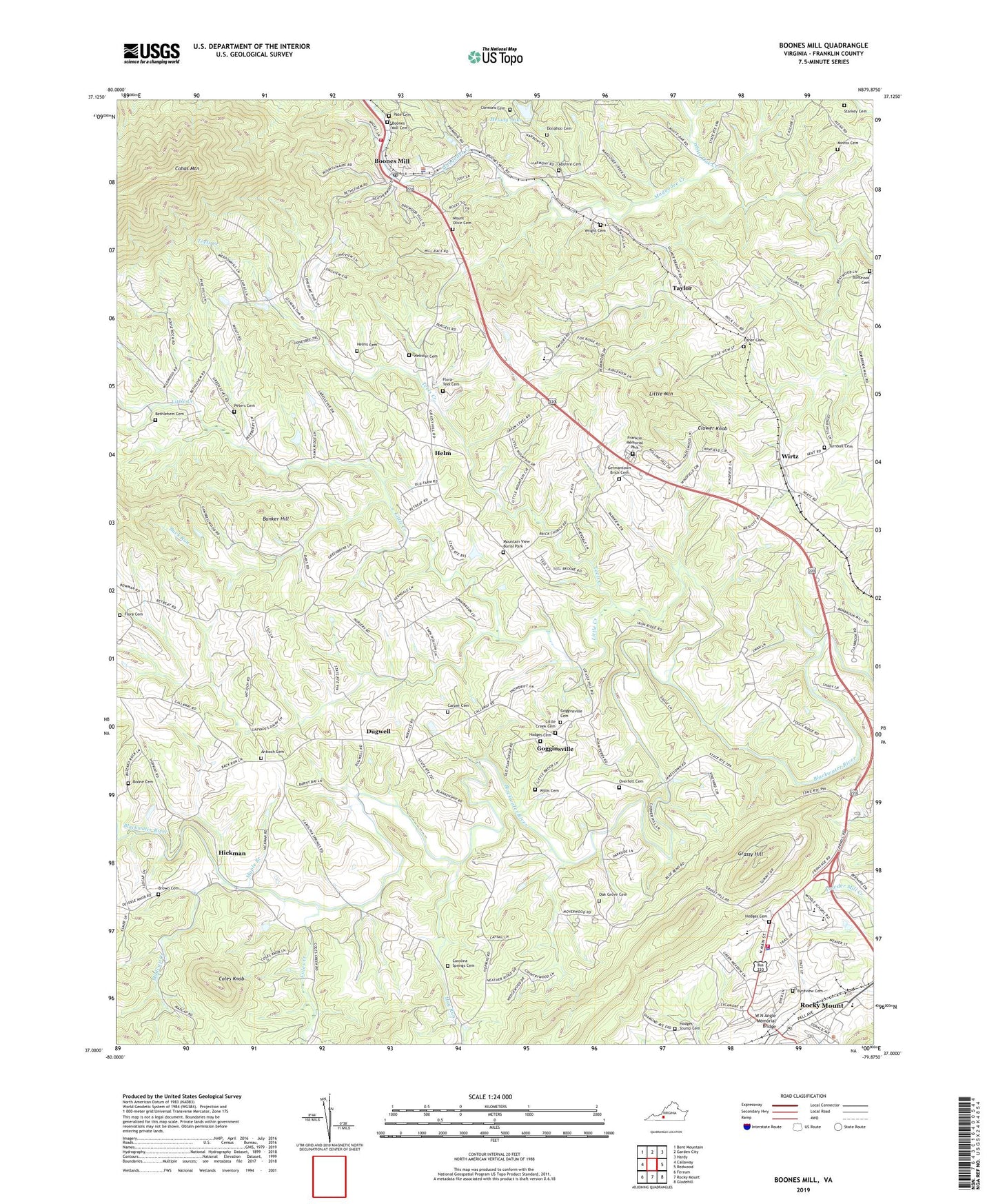
2022 topographic map quadrangle Boones Mill in the state of Virginia. Scale: 1:24000. Based on the newly updated USGS 7.5' US Topo map series, this map is in the following counties: Franklin. The map contains contour data, water features, and other items you are used to seeing on USGS maps, but also has updated roads and other features. This is the next generation of topographic maps. Printed on high-quality waterproof paper with UV fade-resistant inks.
Quads adjacent to this one:
West: Callaway
Northwest: Bent Mountain
North: Garden City
Northeast: Hardy
East: Redwood
Southeast: Gladehill
South: Rocky Mount
Southwest: Ferrum
This map covers the same area as the classic USGS quad with code o37079a8.
Contains the following named places: Abshire Cemetery, Antioch Church, Antioch Church of the Brethren Cemetery, Barney Bay Dairy, Benjamin Franklin Middle School West Hall, Bethlehem Cemetery, Bethlehem Church, Bonbrook, Bonbrook Baptist Church Cemetery, Bonbrook Church, Boone Cemetery, Boones Mill, Boones Mill Baptist Church, Boones Mill Cemetery, Boones Mill Christian Church, Boones Mill Elementary School, Boones Mill Police Department, Boones Mill Post Office, Boones Mill Volunteer Fire Department Company 7, Brick Church, Brown Cemetery, Buck Run, Bunker Hill, Byrdview Cemetery, Carolina Spring Church, Carolina Springs Cemetery, Carper Cemetery, Claiborn, Clemons Cemetery, Clower Knob, Coles Creek, Coles Knob, County High School, County Junior High School, Donahoo Cemetery, Dugwell, Fisher Cemetery, Flora Cemetery, Flora-Teel Cemetery, Franklin County Education Center, Franklin County High School, Franklin Memorial Park, Germantown Brick Cemetery, Gogginsville, Gogginsville Cemetery, Gogginsville Methodist Church, Grassy Hill, Hay Run, Helm, Helms Cemetery, Hickman, Hodges Cemetery, Hodges-Stump Cemetery, Leonard A Gereau Center for Applied Technology, Little Creek, Little Creek Cemetery, Little Creek Church, Little Creek Primitive Baptist Church, Little Mountain, Madcap Creek, Maple Branch, Melody Dam, Melody Lake, Minnix Cemetery, Mount Olive Cemetery, Mount Olive Church, Mount Olive School, Mountain View Burial Park, Oak Grove Cemetery, Oak Grove Church, Overfelt Cemetery, Pate Cemetery, Peters Cemetery, Rocky Mount District, Rocky Mount Police Department, Rocky Mount Shoppers World Shopping Center, Rocky Mount Volunteer Fire Department Company 1, Saint Pauls Church, Starkey Cemetery, Taylor, Teels Creek, Town of Boones Mill, Town of Rocky Mount, Turnbull Cemetery, W N Angle Memorial Bridge, Webster Cemetery, Whispering Oaks Farm, White Oak Creek, White Oak Grove School, Willis Cemetery, Wirtz, Wright Cemetery, WYTI-AM (Rocky Mount), ZIP Code: 24065