MyTopo
Garden City Virginia US Topo Map
Couldn't load pickup availability
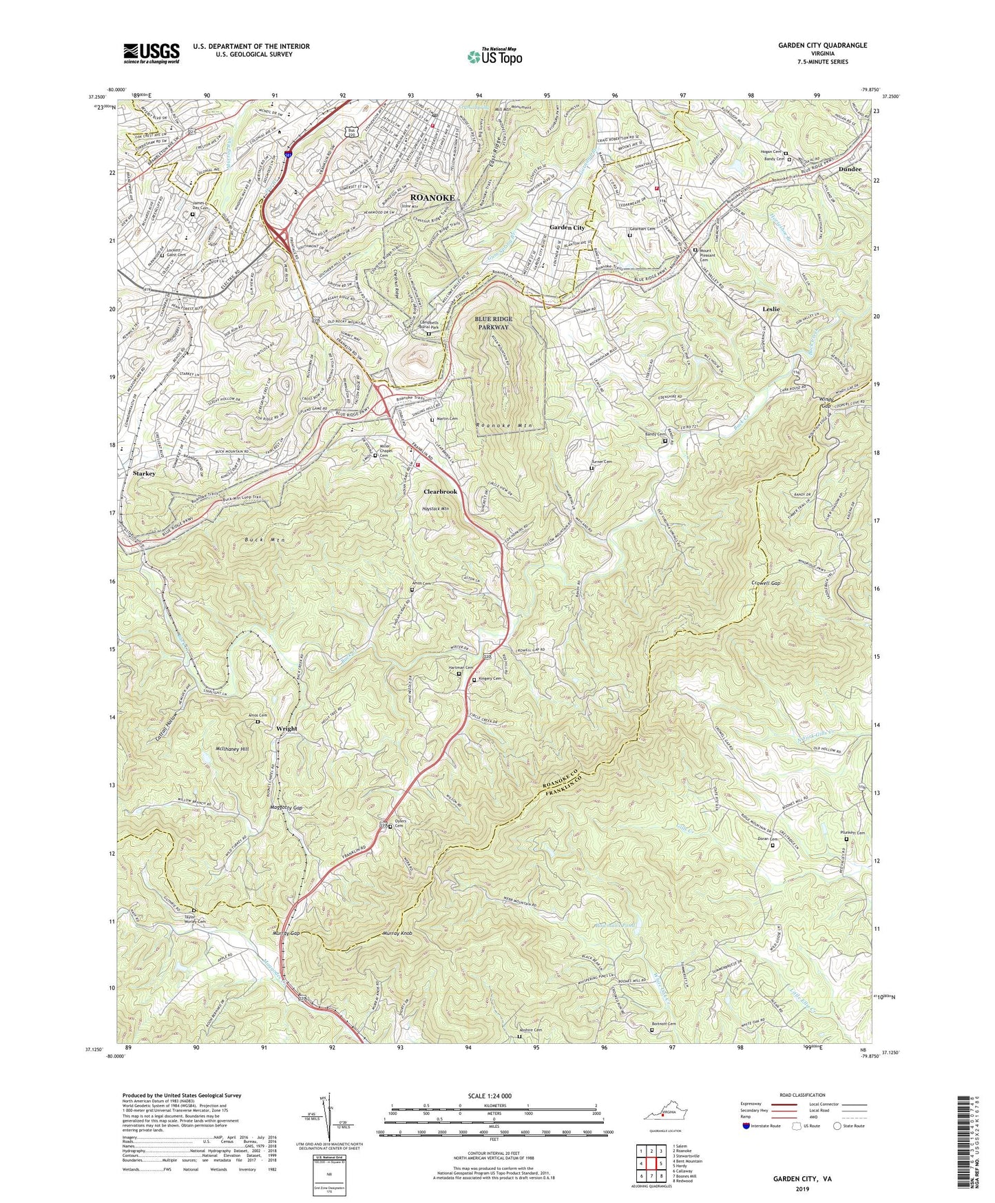
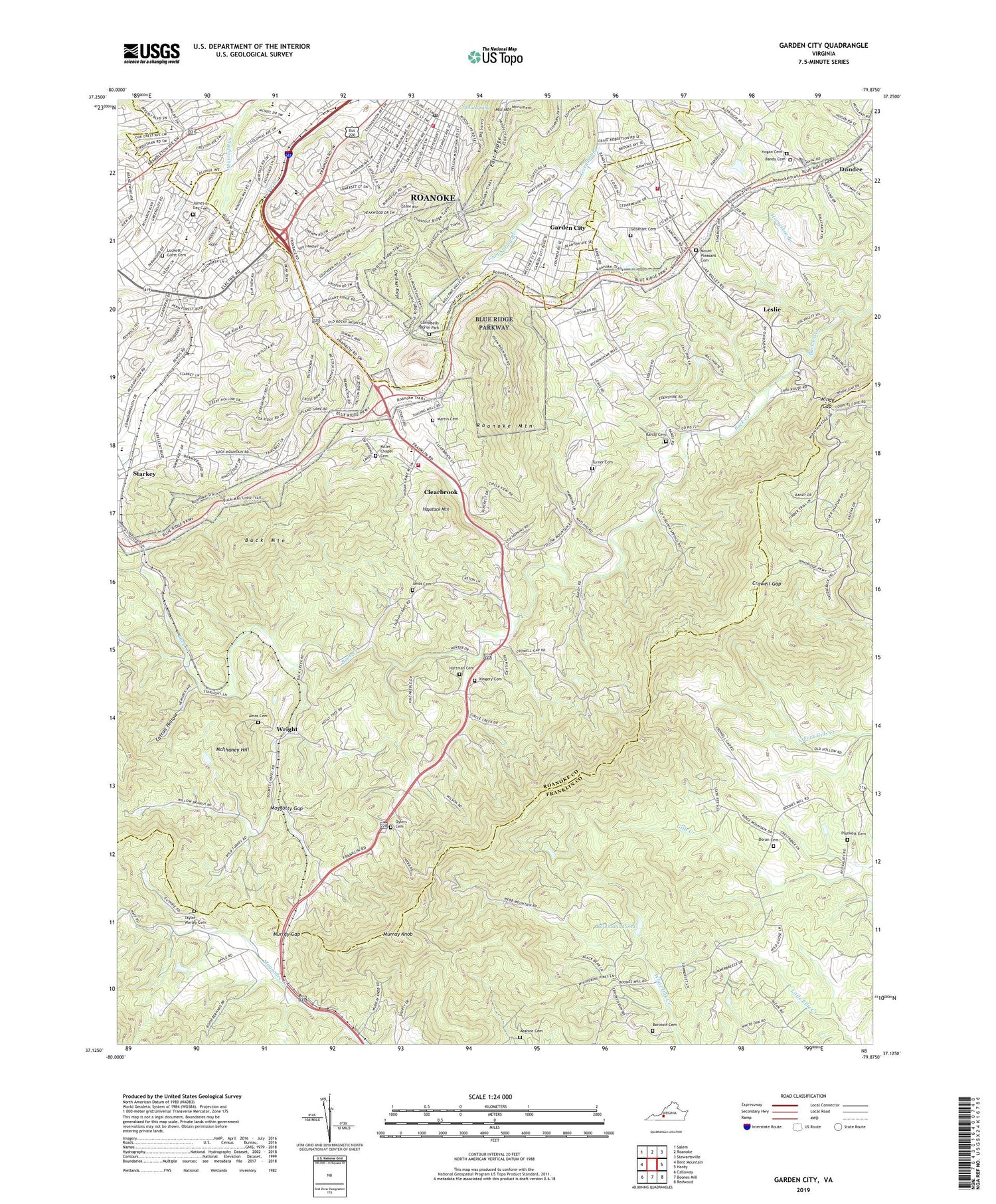
2019 topographic map quadrangle Garden City in the state of Virginia. Scale: 1:24000. Based on the newly updated USGS 7.5' US Topo map series, this map is in the following counties: Roanoke, Franklin, Roanoke (city). The map contains contour data, water features, and other items you are used to seeing on USGS maps, but also has updated roads and other features. This is the next generation of topographic maps. Printed on high-quality waterproof paper with UV fade-resistant inks.
Quads adjacent to this one:
West: Bent Mountain
Northwest: Salem
North: Roanoke
Northeast: Stewartsville
East: Hardy
Southeast: Redwood
South: Boones Mill
Southwest: Callaway
Contains the following named places: Abshire Cemetery, Algoma Park, Amos Cemetery, Bandy Cemetery, Beechwood Gardens, Beulah Heights, Boitnott Cemetery, Boone District, Boones Chapel, Bowmans Dam, Bowmans Pond, Brambleton Court, Brambleton Park, Branderwood, Brookhill Church, Buck Mountain, Buck Mountain Overlook, Campbells Burial Park, Castle Hill, Cattail Hollow, Cave Spring District, Central Church, Chapel Forest, Cherry Hill, Chesterfield, Chestnut Hills, Chestnut Ridge, Clearbrook, Clearbrook Church, Clearbrook Elementary School, Clermont Heights, Cobleshaw, Colonial Church, Crescent Heights, Crowell Gap, Crystal Spring, Crystal Spring Elementary School, Doran Cemetery, Dundee, East Pointe, East Ridge, Edgehill, Edgehill Estates, Englewood, Faith Christian School, Fern Park, First Presbyterian Church, Fishburn Park, Fishburn Park Elementary School, Forest Hills Swim Club, Fralin Park, Garden City, Garden City Baptist Church, Garden City Church of the Nazarene, Garden City Elementary School, Garden City Recreation Building, Gearhart Cemetery, Georgetown Park, Glenmont, Glenwood Estates, Grandin Court, Grandin Court Baptist Church, Grandin Court Elementary School, Green Valley, Green Valley Elementary School, Greenland Hills, Greenwood Forest, Gum Spring Branch, Hampden Hills, Hartman Family Cemetery, Haystack Mountain, Hogan Cemetery, Homeland Hills, Hunting Hills, Hunting Hills Country Club, James E Day Cemetery, James Madison Middle School, Jefferson Hills, Jefferson Park, Kingdom Hall of Jehovahs Witnesses, Kingery Cemetery, Leslie, Lockett - Garst Cemetery, Maggotty Gap, Martin Memorial Cemetery, McIlhaney Hill, Meadowlark, Mill Mountain Estates, Miller Chapel, Miller Chapel Cemetery, Mount Olive Primitive Baptist Church, Mount Pleasant, Mount Pleasant Baptist Church, Mount Pleasant Cemetery, Mount Pleasant Elementary School, Murray Gap, Murray Knob, Narrows, New Hope Church, Ogden Elementary School, Ogden Hills, Olympic Park Pool, Oylers Cemetery, Parkway Acres, Parkway Meadows, Peakwood Hills, Penn Forest Elementary School, Piney Grove Church, Pinkard Court, Pinkard Court School, Plunkett Cemetery, Prospect Hills, Prospect Valley, Red Hill Church, Richart Heights, Roanoke County Fire and Rescue Station 6 - Mount Pleasant Fire Department, Roanoke County Fire and Rescue Station 7 - Clearbrook Fire Department, Roanoke Fine Arts Center, Roanoke Fire - EMS Station 8, Roanoke Mountain, Rockingham Court, Rockingham Court Church, Rorer Mines, Ruxton, Shedd Montessori School, Sherwood Forest, Slate Hill Church, South Roanoke Baptist Church, South Roanoke Post Office, South Roanoke United Methodist Church, Southern Hills, Southern Pines, Spring Valley, Starkey, Stone Mountain, Sun Valley Swim Club, Suncrest Heights, Tanglewood Mall Shopping Center, Taylor-Worley Cemetery, Townside Festival Shopping Center, Turner - Richardson Cemetery, Virginia Western Community College, Wildwood, Windy Gap, Woodcliff, Woodland Park, Woodlawn United Methodist Church, Woods Crossing, Wright, Yellowstone, Yostland Heights, ZIP Code: 24014