MyTopo
Gore Virginia US Topo Map
Couldn't load pickup availability
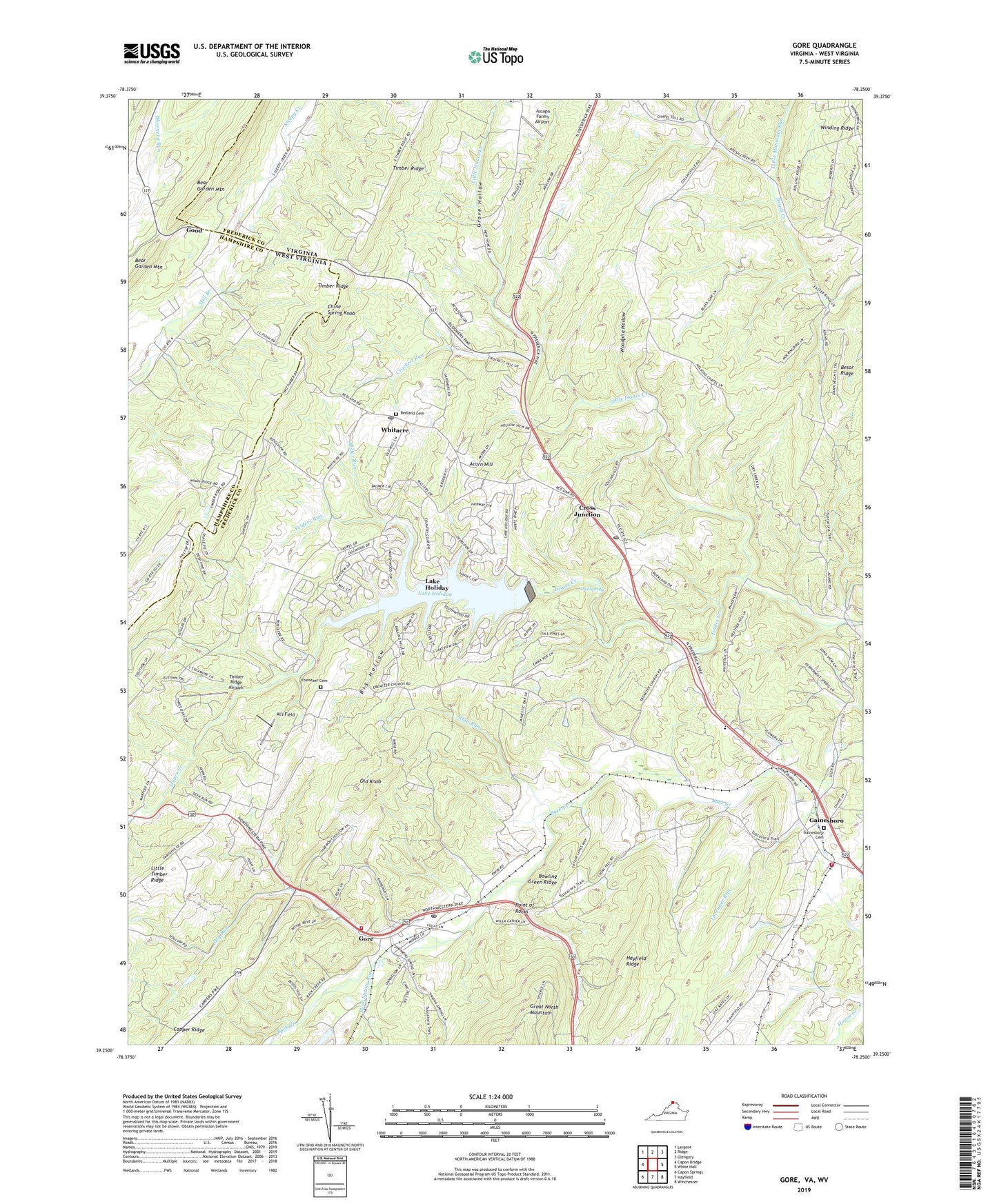
2019 topographic map quadrangle Gore in the states of Virginia, West Virginia. Scale: 1:24000. Based on the newly updated USGS 7.5' US Topo map series, this map is in the following counties: Frederick, Hampshire. The map contains contour data, water features, and other items you are used to seeing on USGS maps, but also has updated roads and other features. This is the next generation of topographic maps. Printed on high-quality waterproof paper with UV fade-resistant inks.
Quads adjacent to this one:
West: Capon Bridge
Northwest: Largent
North: Ridge
Northeast: Glengary
East: White Hall
Southeast: Winchester
South: Hayfield
Southwest: Capon Springs
Contains the following named places: Acorn Hill, Albin Run, Al's Field, Back Creek Quaker Cemetery, Back Creek School, Besor Ridge, Big Hollow, Bloomery School, Bowling Green Ridge, Broadway School, Cacapon State Park Lake, Capper Ridge, Cathers School, Chine Spring Knob, Cold Spring, Collinsville, Country Club Heights, Crockett Run, Cross Junction, Cross Junction Post Office, Cross Junction School Number 1, Cross Junction School Number 2, Dry Run, Ebenezer Christian Church Cemetery, Ebenezer Church, Ebenezer School, Fairway Heights, Fairway Meadows, Frederick County Fire and Rescue Department Station 14 - Gore Volunteer Fire and Rescue, Frederick County Fire and Rescue Department Station 16 - Gainesboro Volunteer Fire and Rescue, Gainesboro, Gainesboro District, Gainesboro Neighborhood Park, Gainesboro School Number 1, Gainesboro United Methodist Church, Good, Gore, Gore Census Designated Place, Gore Elementary School, Gore Post Office, Gore School Number 1, Great North Mountain, Grove Hollow, Hayfield Ridge, Hebron Baptist Church, Indian Run Dam, Jucapa Farms Airport, Lake Holiday, Lake Holiday Census Designated Place, Lake Holiday Country Club, Lakewood Acres, Lew School, Little Isaacs Creek, Little Mountain Run, Little Timber Ridge, Lost School, Miller Run, Mine Spring Run, Mosswood Hills, Mount Hebron Church, Mountain View Acres, Nordic Village, Northwood Hills, Old Knob, Patterson School, Point of Rocks, Railroad Union School, Redland Cemetery, Redland Church, Redland School, Rolling Hills, Smiths School, Southwood Hills, Tavenner Run, The Knolls, The Summit Dam, Timber Ridge, Timber Ridge Airpark, Whitacre, Whitacre Post Office, White Oak Mansion School, White Oak School Number 1, Wildwood Hills, Woodpile Hollow, Yeiders Run, ZIP Code: 22637