MyTopo
Irvington Virginia US Topo Map
Couldn't load pickup availability
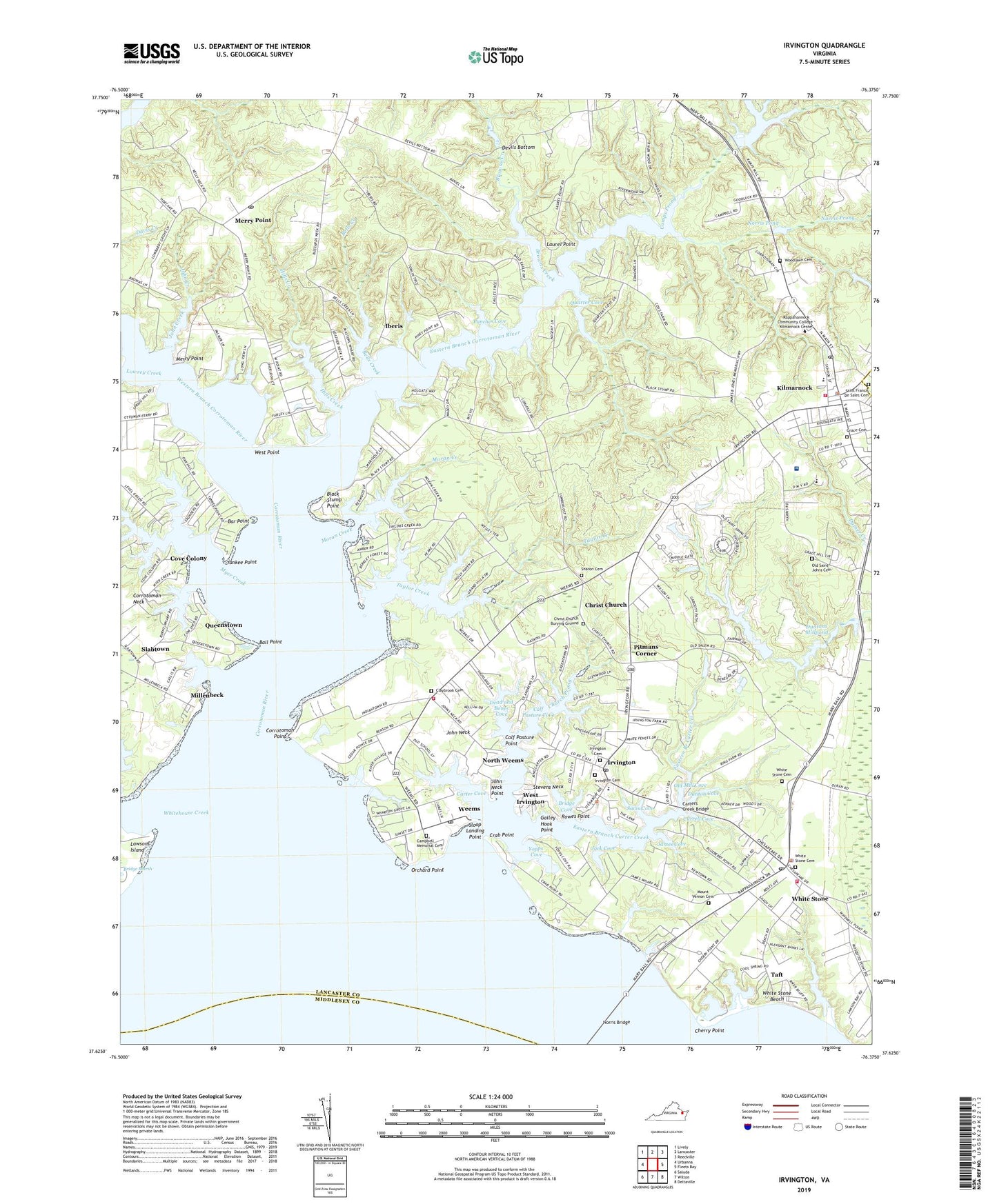
2019 topographic map quadrangle Irvington in the state of Virginia. Scale: 1:24000. Based on the newly updated USGS 7.5' US Topo map series, this map is in the following counties: Lancaster, Middlesex, Northumberland. The map contains contour data, water features, and other items you are used to seeing on USGS maps, but also has updated roads and other features. This is the next generation of topographic maps. Printed on high-quality waterproof paper with UV fade-resistant inks.
Quads adjacent to this one:
West: Urbanna
Northwest: Lively
North: Lancaster
Northeast: Reedville
East: Fleets Bay
Southeast: Deltaville
South: Wilton
Southwest: Saluda
Contains the following named places: Ball Point, Bar Point, Bells Creek, Black Stump Point, Black Stump School, Bridge Cove, Browns Creek, Calf Pasture Cove, Calf Pasture Point, Campbell Memorial Church, Campbell Memorial Presbyterian Church Cemetery, Camps and Carters Mill, Camps Millpond, Camps Prong, Carter Cove, Carter Creek, Carters Creek Bridge, Cherry Point, Chesapeake Academy, Christ Church, Christ Church Cemetery, Church Prong, Claybrook Baptist Church Cemetery, Claybrook Church, Corrotoman Point, Corrotoman River, Cove Colony, Crab Point, Currell Cove, Dead and Bones Cove, Devils Bottom, District 4, District 5, Dunton Cove, Dunton Mill, Duntons Millpond, Eastern Branch Carter Creek, Eastern Branch Corrotoman River, Galley Hook Point, Golden Eagle Dam, Golden Eagle Golf Club, Golden Eagle Pond, Grace Cemetery, Grace Church, Hills Creek, Iberis, Irvington, Irvington Cemetery, Irvington Marina Seaplane Base, Irvington Post Office, Jack Cove, James Cove, John Creek, John Neck, John Neck Point, Kilmarnock, Kilmarnock Lancaster County Volunteer Rescue Squad, Kilmarnock Police Department, Kilmarnock Post Office, Kilmarnock Volunteer Fire Department, Lancaster County, Lancaster Middle School, Lancaster Roller Mill Dam, Laurel Point, Lowrey Creek, Mars Hill School, Merry Point, Merry Point Ferry, Merry Point Post Office, Merry Point School, Millenbeck, Moran Creek, Moran Wharf, Mount Jean School, Mount Vernon Cemetery, Mount Vernon Church, Myer Creek, New Saint Johns Church, Norris Pond, Norris Prong, North Weems, Old Mill Cove, Old Saint John Baptist Church, Old Saint Johns Cemetery, Orchard Point, Ottoman Wharf, Palmer Hall, Pilgrim Church, Pitmans Corner, Port of Rappahannock, Punches Cove, Quarter Cove, Queenstown, Rappahannock General Hospital, Rappahannock General Hospital Heliport, Rowes Point, Saint Francis De Sales Catholic Church, Saint Francis De Sales Cemetery, Sams Cove, Sanders Cove, Sharon Cemetery, Sharon Church, Slabtown, Sloop Landing, Sloop Landing Point, Stevens Dam, Stevens Neck, Taft, Taft Post Office, Tartan Golf Club, Taylor Creek, Town Creek, Town of Irvington, Town of Kilmarnock, Town of White Stone, Weems, Weems Census Designated Place, Weems Landing Strip, Weems Post Office, Wesley Church, West Irvington, West Point, Western Branch Corrotoman River, Western Branch Taylors Creek, Wharton Grove, Wharton Grove Camp, White Stone, White Stone Beach, White Stone Cemetery, White Stone Church, White Stone District, White Stone Police Department, White Stone Post Office, White Stone United Methodist Church, White Stone Volunteer Fire Department, White Stone Volunteer Fire Department Weems Station, White Stone Wharf, Whitehouse Creek, WKWI-FM (Kilmarnock), Woodlawn Cemetery, Yankee Point, Yankee Point Landing, Yopps Cove, ZIP Codes: 22480, 22576