MyTopo
Reedville Virginia US Topo Map
Couldn't load pickup availability
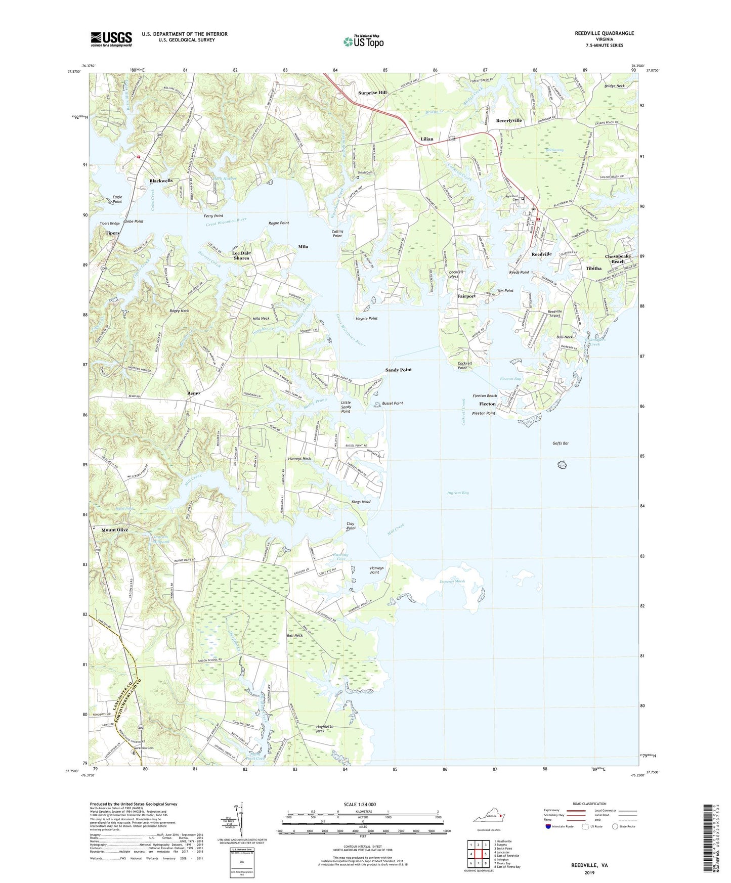
2022 topographic map quadrangle Reedville in the state of Virginia. Scale: 1:24000. Based on the newly updated USGS 7.5' US Topo map series, this map is in the following counties: Northumberland, Lancaster. The map contains contour data, water features, and other items you are used to seeing on USGS maps, but also has updated roads and other features. This is the next generation of topographic maps. Printed on high-quality waterproof paper with UV fade-resistant inks.
Quads adjacent to this one:
West: Lancaster
Northwest: Heathsville
North: Burgess
Northeast: Smith Point
East: East of Reedville
Southeast: East of Fleets Bay
South: Fleets Bay
Southwest: Irvington
This map covers the same area as the classic USGS quad with code o37076g3.
Contains the following named places: Apple Grove Airport, Bailey Prong, Ball Creek, Ball Neck, Balls Creek, Barrett Creek, Bell Swamp, Bethany Church, Betts Mill Creek, Beverlyville, Blackberry, Blackwells, Bogey Neck, Bridge Neck School, Bull Neck, Bussel Point, Buzzard's Point Marina, Carlson Store, Chesapeake Beach, Clay Point, Cloverdale Creek, Cockrell Creek, Cockrell Neck, Cockrell Point, Coles Creek, Collins Point, Cranes Creek, Dameron Marsh, Delanos Store, District 4, District 5, Eagle Point, Fairfields Volunteer Fire Department, Fairfields Volunteer Fire Department - Glebe Point Fire House, Fairport, Fairport Marina, Ferry Point, Fleet Point Light, Fleeton, Fleeton Bay, Fleeton Beach, Fleeton Point, Gascony Cove, Gaskin Pond, Glebe Point, Glebe Point Landing, Goffs Bar, Gougher Creek, Great Wicomico River, Harveys Creek, Harveys Neck, Harveys Point, Haynie Point, Hope Union Cemetery, Horn Harbor, Hughletts Neck, Hurst Dam, Hurst Pond, Ingram Bay, Ingram Bay Marina, Ingram Millpond, Ingrams Mill, Jeanes School, Julius Rosenwald School, Kings Head, Lee Dale Shores, Liberty Methodist Protestant Church, Lighthouse Christian Academy, Lilian, Little Sandy Point, Mila, Mila Church, Mila Neck, Mila School, Mill Creek, Morattico Cemetery, Morattico Church, Mount Olive, Mount Olive Church, Natty Point Cove, Northumberland County Rescue Squad, Northumberland Volunteer Rescue Squad Station 1, Owens Pond, Penny Creek, Reason Creek, Reeds Point, Reedville, Reedville Airport, Reedville High School, Reedville Historic District, Reedville Post Office, Rehoboth Church, Rehoboth United Methodist Church, Remo, Remo Private Airport, Rogue Point, Roseland Cemetery, Saint Marys Church, Salt Pond, Sandy Point, Shell Creek, Shiloh Church, Shiloh School, Smith Point Sea Rescue 1, Surprise Hill, Taskmakers Creek, Tibitha, Tibitha Church of God, Tim Point, Tipers, Tipers Bridge, Tipers Creek, Towles Creek, Waddeys, Warehouse Creek, Whays Creek, Wicomico Church, ZIP Codes: 22432, 22539, 22579