MyTopo
Moneta SW Virginia US Topo Map
Couldn't load pickup availability
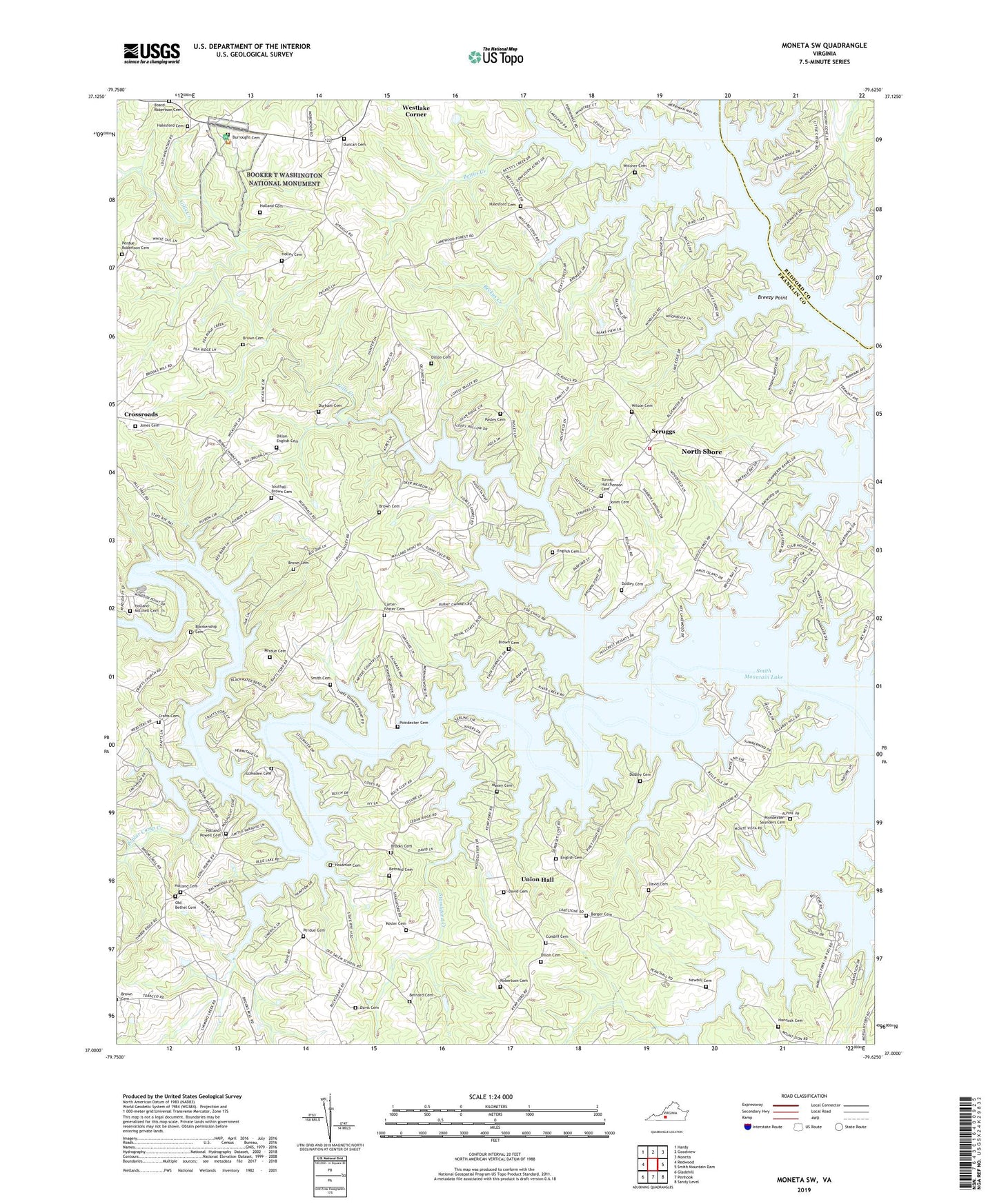
2019 topographic map quadrangle Moneta SW in the state of Virginia. Scale: 1:24000. Based on the newly updated USGS 7.5' US Topo map series, this map is in the following counties: Franklin, Bedford. The map contains contour data, water features, and other items you are used to seeing on USGS maps, but also has updated roads and other features. This is the next generation of topographic maps. Printed on high-quality waterproof paper with UV fade-resistant inks.
Quads adjacent to this one:
West: Redwood
Northwest: Hardy
North: Goodview
Northeast: Moneta
East: Smith Mountain Dam
Southeast: Sandy Level
South: Penhook
Southwest: Gladehill
Contains the following named places: Arrowhead, Beckys Creek, Berger Cemetery, Bernard Cemetery, Bernard Dam, Bettys Creek, Blankenship Cemetery, Board-Robertson Cemetery, Booker T Washington National Monument, Brammer Seaplane Base, Breezy Point, Brooks Cemetery, Brown Cemetery, Brown Cemetery Number 2, Bull Run, Burroughs Cemetery, Carter-Foster Cemetery, Crafts Cemetery, Crafts Church, Crafts Ford, Crafts Point, Crazy Horse Campground, Cundiff Cemetery, David Cemetery, Davis Cemetery, Dillon Cemetery, Dillon-English Cemetery, Dudley Cemetery, Duncan Cemetery, Durham Cemetery, English Cemetery, Foxsport, Gills Creek, Gills Creek District, Greers Ford, Haleford Church, Hales Ford Methodist Church Cemetery, Halesford Cemetery, Halesford United Methodist Church, Hancock Cemetery, Holland - Powell Cemetery, Holland Cemetery, Holland-Mitchell Cemetery, Holley Cemetery, Holleys Mill, Housman Cemetery, Hutchinsons Mill, Indian Ridge Baptist Church Cemetery, Indian Ridge Church, Isle of Pines, Jones Cemetery, Kesler Cemetery, Little Bull Run, Lumsden Cemetery, Maxey Cemetery, Mount Ivy Churches, Mount Zion Church, Newbill Cemetery, North Shore, North Shore Census Designated Place, Old Bethel Church, Pasley Cemetery, Pelican Point, Penhook State Boat Ramp, Perdue Cemetery, Perdue-Robertson Cemetery, Poindexter - Saunders Cemetery, Poindexter Cemetery, Poplar Camp Creek, Radfords Ford, Robertson Cemetery, Scruggs, Scruggs Volunteer Fire Department and Rescue Squad Company 10, Smith Cemetery, Smith Cemetery at Old Bethel Church, Smiths Paradise, Southall-Brown Cemetery, Standiford Creek, The Waterfront, Turner-Hutchenson Cemetery, Union Hall, Union Hall Census Designated Place, Union Hall Church, Union Hall District, Westlake Corner, Westlake Corner Census Designated Place, White Pine, Wilson Family Cemetery, Witcher Cemetery, ZIP Code: 24176