MyTopo
Mulberry Island Virginia US Topo Map
Couldn't load pickup availability
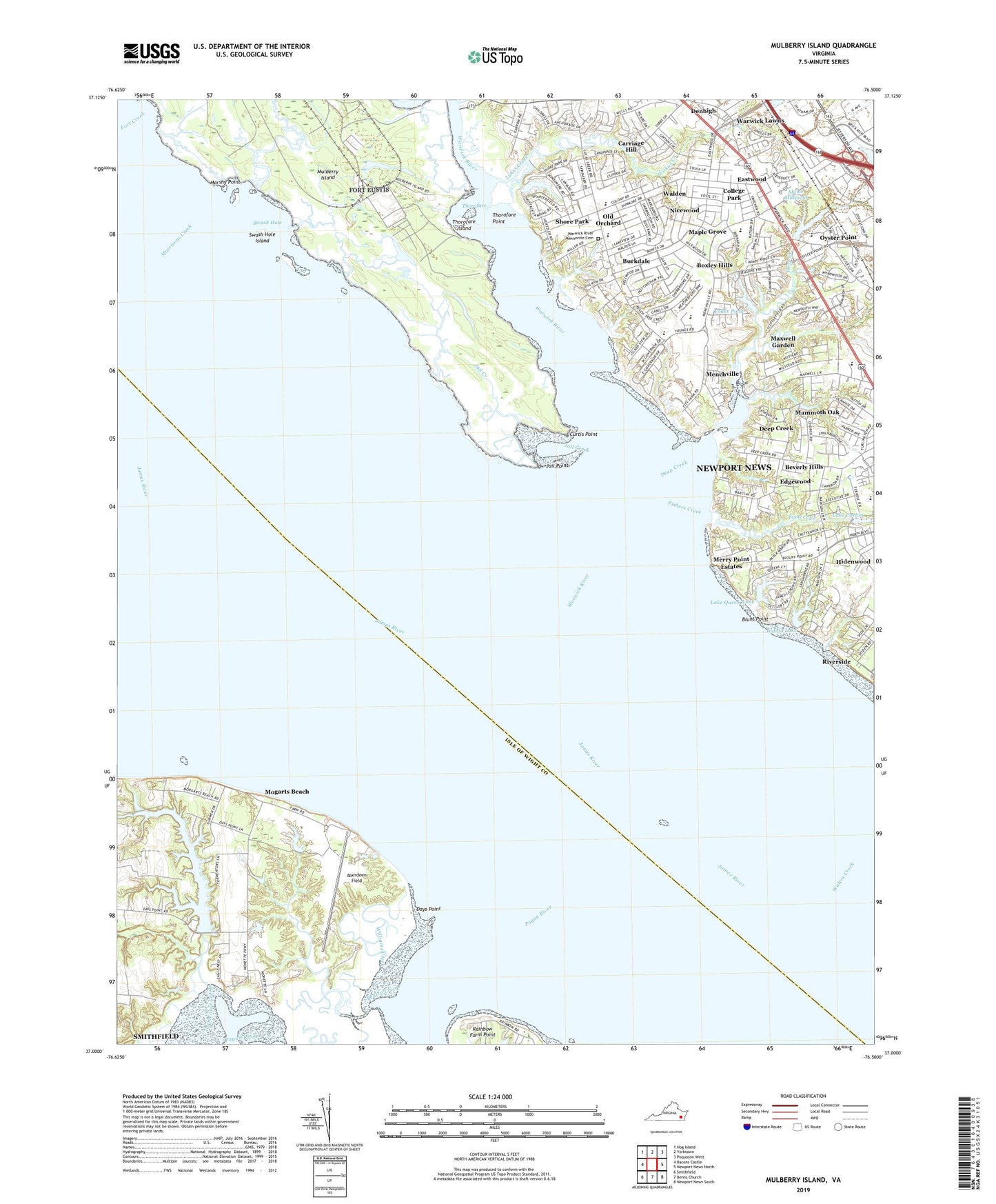
2022 topographic map quadrangle Mulberry Island in the state of Virginia. Scale: 1:24000. Based on the newly updated USGS 7.5' US Topo map series, this map is in the following counties: Newport News (city), Isle of Wight. The map contains contour data, water features, and other items you are used to seeing on USGS maps, but also has updated roads and other features. This is the next generation of topographic maps. Printed on high-quality waterproof paper with UV fade-resistant inks.
Quads adjacent to this one:
West: Bacons Castle
Northwest: Hog Island
North: Yorktown
Northeast: Poquoson West
East: Newport News North
Southeast: Newport News South
South: Benns Church
Southwest: Smithfield
This map covers the same area as the classic USGS quad with code o37076a5.
Contains the following named places: Aberdeen Dam, Aberdeen Field, Aberdeen Pond, B C Charles Elementary School, Barclay Woods, Beatty Creek, Bethel Temple Real World Worship Center, Beverly Hills, Blunt Point, Boxley Hills, Burkdale, Carriage Hill, Chesapeake Village Mobile Home Park, Christ Church, City of Newport News, College Park, Crossroads Deliverance Church, Curtis Point, Days Point, Deep Creek, Denbigh Baptist Christian School, Denbigh Baptist Church, Denbigh Church, Denbigh Park, Eastwood, Edgewood, Eternal Life Church, Ethel M Gildersleeve Middle School, First Baptist Church, Fishers Creek, Fort Boykin, Grace and Truth Fellowship Church, Grace Church, Hampton Roads Sanitation District James River Sewage Treatment Plant, Hampton Roads Wastewater Treatment Plant, Hiddenwood Presbyterian Church, Hidenwood, Hidenwood Elementary School, Hoopes Landing, Indigo Lake, Jail Creek, Jail Point, James River Country Club, James River Marina, Jenkins Elementary School, Lake Corbin, Lake Queen Anne, Lake Tormentor, Lukas Creek, Mammoth Oak, Maple Grove, Marshy Point, Maxwell Garden, Menchville, Menchville High School, Mennonite Colony, Merry Point Estates, Mogarts Beach, Morrisons Creek, Mulberry Island, New Horizons Regional Education Center - Autism, Newport News Department of Adult Corrections, Newport News Nursing and Rehabilitation Center, Nicewood, Nicewood Park, Old Orchard, Oyster Point, Oyster Point Marketplace Shopping Center, Oyster Point Plaza Shopping Center, Pagan River, Pates Field, Providence Church, Providence Mennonite Church, Rainbow Farm Point, Richard T Yates Elementary School, River of Life Christian Church, Riverview Farm Park, Rock Church of Newport News, Sanford Elementary School, Sherwood Shopping Center, Shore Park, Sluice Dam, Sluice Millpond, Swash Hole, Swash Hole Island, Tabernacle Church, The Peninsula Pentecostals Church, Thorofare, Thorofare Island, Thorofare Point, Tormentor Creek, Tormentor Dam, Union Chapel, Village Square Shopping Center, Walden, Warwick Lawns, Warwick River, Warwick River Christian School, Warwick River Mennonite Cemetery, Warwick Yacht Club, Watergate Estates, Wendwood, Williams Creek, Yoder Pond, ZIP Codes: 23602, 23604, 23606