MyTopo
Norfolk North Virginia US Topo Map
Couldn't load pickup availability
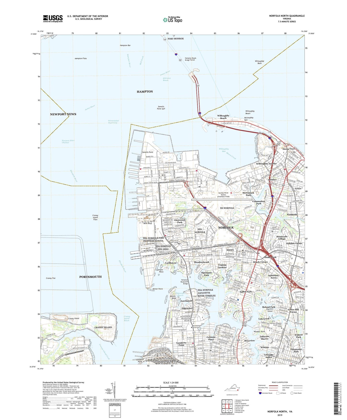
2022 topographic map quadrangle Norfolk North in the state of Virginia. Scale: 1:24000. Based on the newly updated USGS 7.5' US Topo map series, this map is in the following counties: Norfolk (city), Hampton (city), Portsmouth (city), Newport News (city). The map contains contour data, water features, and other items you are used to seeing on USGS maps, but also has updated roads and other features. This is the next generation of topographic maps. Printed on high-quality waterproof paper with UV fade-resistant inks.
Quads adjacent to this one:
West: Newport News South
Northwest: Newport News North
North: Hampton
Northeast: East of Hampton
East: Little Creek
Southeast: Kempsville
South: Norfolk South
Southwest: Bowers Hill
This map covers the same area as the classic USGS quad with code o36076h3.
Contains the following named places: Algonquin Park, Anchorage F-1 Light, Armed Forces Staff College, Arrowood Academy, Battery Claiborne, Battery Dyer, Battery Gates, Battery Hindman, Battery Lee, Bay View Park, Blessed Sacrament School, Bon Secours DePaul Medical Center, Boush Creek, Boushs Bluff, Bush Bluff, Camp Allen Elementary School, Captains Quarters Nature Center And Park, Carolton Oaks School, Casterton Trailer Park, Catholic High School, Central Trailer Park, Charters Island, Christ the King Catholic School, Churchland High School, Cinclantflt Heliport, Coal Pier 4, Coal Pier 5, Coal Pier 6, Coast Guard Station Portsmouth, Colonial Place, Commodore Park, Cottage Road Park, Craney Flat, Craney Island, Craney Island Creek, Craney Island Disposal Area, Craney Island Flats, Craney Island Fuel Depot, Craney Island Reach, Crossroads Elementary School, Denby Park, Early Childhood Center at Stuart, East Haven, Edgewater, Edgewater Haven, Elizabeth River, Entrance Reach, Euwanee Park, Fairmount Park, Fairwater, Fleet Park, Fleet Post Office, Foreman Field, Forest Lawn Cemetery, Fort Wool, Fort Wool Light, Glenwood Park, Governor's School for the Arts, Granby Elementary School, Granby High School, Granby Shores, Granby Street Park, Grandy Street Bridge, Green Hill Farms, Greenway Park, Hampton Bar, Hampton Bar Light, Hampton Boulevard Bridge, Hampton Flats, Hampton Roads, Hampton Roads Anchorage Light, Hampton Roads Bridge Tunnel, Hampton Roads Sanitation District Army Base Sewage Treatment Plant, Hampton Roads Sanitation District Virginia Initiative Sewage Treatment Plant, Harrisons Pier, Health and Physical Education Building, Hermitage Foundation Museum, Holy Trinity School, Hughes Hall, Hugo A. Owens African American Cultural Center, Islamic Center, James Monroe Elementary School, Joint Forces Staff College, Joint Forces Staff College Post Office, Kaufman Engineering Hall, Knitting Mill Creek, Komblau Alumni Center, Lafayette - Winona Middle School, Lafayette Annex, Lafayette Park, Lafayette River, Lafayette Shores, Lafayette Shores Shopping Center, Lafayette Yacht Club, Lakewood, Lakewood Park, Lakewood School, Lamberts Point, Lambert's Point Golf Club, Larchmont, Larchmont Elementary School, Lawless Point, Lenox, Lions Child Study Center, Loch Meadow Kindergarten, Lochhaven, Madison Career Center, Madison School, Mary Calcott Elementary School, Mary Denson Pretlow Planetarium, Mason Creek, McLea School, Meadowbrook, Meadowbrook Elementary School, Meadowbrook Shopping Center, Merrimack Park, Midtown Shopping Center, Milan Post Office, Miller Heights, Mills Godwin Jr. Science Building, Monarch House, Monticello Village, Mount Pleasant Cemetery, Naval Base Golf Course, Naval Base Post Office, Naval Station Norfolk, Naval Support Activity Norfolk, Norfolk Academy, Norfolk Alternative High School, Norfolk Alternative Middle School, Norfolk Christian Discovery Center, Norfolk Christian School - Norfolk Campus, Norfolk Christian Upper School, Norfolk Collegiate School, Norfolk Collegiate School Lower School, Norfolk International Terminals, Norfolk Masjid Islamic School, Norfolk Naval Station (Chambers Field), Norfolk Naval Station Golf Course, Norfolk Yacht and Country Club, Northside, Northside Middle School, Northside Park, Oakdale Farms, Oakwood School, Oastes Creek, Ocean View Christian Academy, Ocean View Elementary School, Ocean View Golf Course, Ocean View Post Office, Oceanair Elementary School, Old Dominion University, Old Dominion University Child Study Center, Pamlico, Parkdale Private School, Pier 1, Pier 10, Pier 11, Pier 12, Pier 2, Pier 20, Pier 21, Pier 22, Pier 23, Pier 24, Pier 25, Pier 3, Pier 4, Pier 5, Pier 6, Pier A, Pier B, Pier C, Pier D, Pier E, Pier F, Pier G, Pier H, Pine Beach, Pinewell, Portsmouth City Craney Island Landfill, Powhatan Field, Riverview, Roland Park, Roland Park Shopping Center, Ruxton, Saint John Lutheran School, Saint Patrick Catholic School, Sewells Point, Sewells Point Docks, Sewells Point Elementary School, Sewells Point Golf Course, Sewells Point Spit, Smallwood School, Snug Harbor Shopping Center, Southern Shopping Center, Stuart Gifted Center School, Suburban Acres, Suburban Park Elementary School, Sussex, Talbot Park, Tanner Creek, Tanner Point, Tanners Cross Roads, Tidewater Shopping Center, Titustown School, United States Public Health Service Hospital, Virginia Gardens, Virginia Zoological Park, Wards Corner, Wards Corner Shopping Center, Wayne Creek, WBSK-AM (Portsmouth), Willard Model Elementary School, Willard Park, Willoughby Bank, Willoughby Bay, Willoughby Beach, Willoughby Boat Ramp, Willoughby Elementary School, Willoughby Harbor Marina, Willoughby Spit, Willoughby Terrace, Willowood Shopping Center, Windsor Point, Winona, WNIS-AM (Portsmouth), Wright Post Office, ZIP Codes: 23503, 23505, 23508, 23509, 23511, 23551, 23703