MyTopo
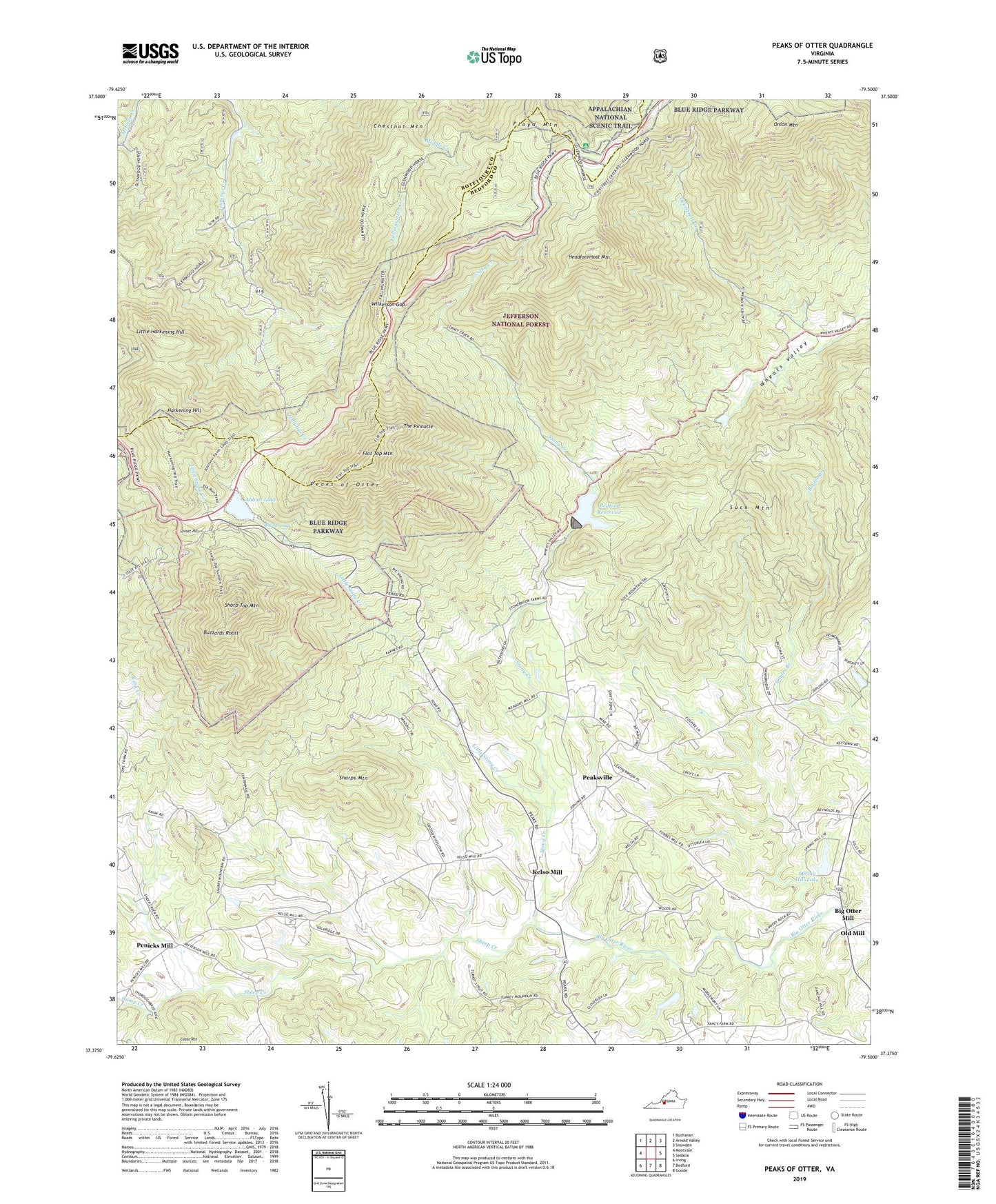
Peaks of Otter Virginia US Topo Map
Couldn't load pickup availability
Also explore the Peaks of Otter Forest Service Topo of this same quad for updated USFS data
2022 topographic map quadrangle Peaks of Otter in the state of Virginia. Scale: 1:24000. Based on the newly updated USGS 7.5' US Topo map series, this map is in the following counties: Bedford, Botetourt. The map contains contour data, water features, and other items you are used to seeing on USGS maps, but also has updated roads and other features. This is the next generation of topographic maps. Printed on high-quality waterproof paper with UV fade-resistant inks.
Quads adjacent to this one:
West: Montvale
Northwest: Buchanan
North: Arnold Valley
Northeast: Snowden
East: Sedalia
Southeast: Goode
South: Bedford
Southwest: Irving
This map covers the same area as the classic USGS quad with code o37079d5.
Contains the following named places: Abbott Lake, Antioch Church, Bedford Country Club, Bedford Dam, Bedford Reservoir, Big Otter Mill, Big Spring, Black Rock Hill Overlook, Buzzards Roost, Camp Creek, Chestnut Mountain, Cornelius Shelter, Fallingwater Creek, Fallingwater Overlook, Fallingwater Trail, Flat Top Mountain, Flat Top Mountain Overlook, Flat Top Mountain Trail, Floyd Mountain, Harkening Hill, Headforemost Mountain, Headforemost Mountain Overlook, Jennings Church, Kelso Mill, Laurel Grove Presbyterian Church, Little Harkening Hill, Little Stony Creek, Lower Pattersons Mill, Mount Joy Church, Old Bedford City Dam, Old Mill, Onion Mountain, Onion Mountain Overlook, Peaks Church, Peaks District, Peaks of Otter, Peaks of Otter Dam, Peaks of Otter Recreation Area, Peaksville, Penicks Mill, Reba Creek, Salem Church, Sharp Top Mountain, Sharps Mountain, Sheep Creek, Spring Hill Lake, Spring Hill Lake Dam, Stony Creek, Suck Mountain, Suck Spring Church, Sunset Hill, Temple Church, The Pinnacle, Wheats Valley, Wilkerson Gap