MyTopo
Cathlamet Washington US Topo Map
Couldn't load pickup availability
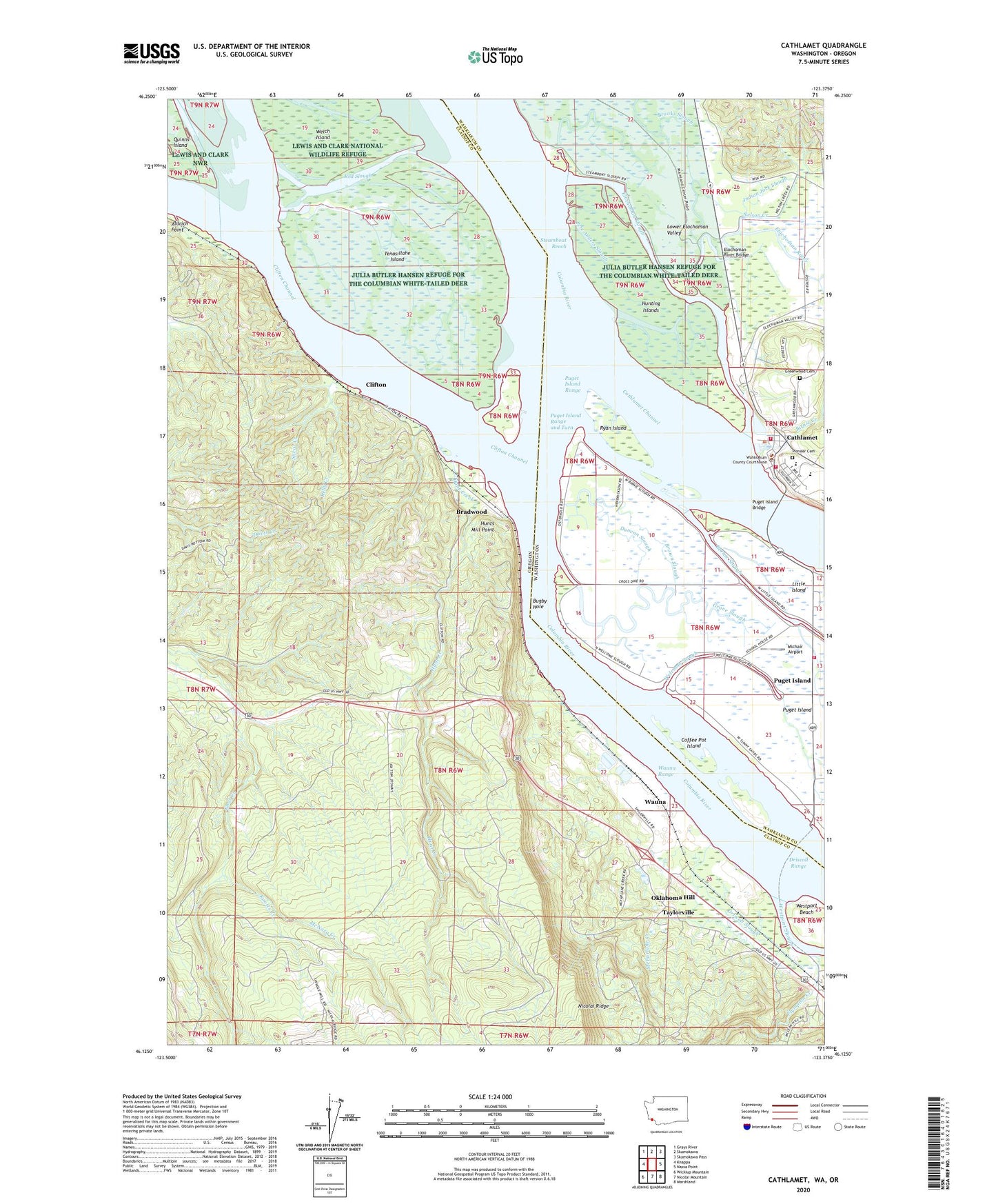
2020 topographic map quadrangle Cathlamet in the states of Oregon, Washington. Scale: 1:24000. Based on the newly updated USGS 7.5' US Topo map series, this map is in the following counties: Wahkiakum, Clatsop. The map contains contour data, water features, and other items you are used to seeing on USGS maps, but also has updated roads and other features. This is the next generation of topographic maps. Printed on high-quality waterproof paper with UV fade-resistant inks.
Quads adjacent to this one:
West: Knappa
Northwest: Grays River
North: Skamokawa
Northeast: Skamokawa Pass
East: Nassa Point
Southeast: Marshland
South: Nicolai Mountain
Southwest: Wickiup Mountain
Contains the following named places: Aldrich Point, Ankeny Landing Light, Bernie Slough, Birnie Creek, Bradley State Park, Bradwood, Bradwood Post Office, Brown Slough, Bugby, Bugby Hole, Cathlamet, Cathlamet Assembly of God Church, Cathlamet Blanche Bradley Library, Cathlamet Christian Fellowship Church, Cathlamet City Park, Cathlamet Congregational Church, Cathlamet Fire Department, Cathlamet Fire Department Station 2, Cathlamet Post Office, Cathlamet Town Hall, Cathlamet Wastewater Treatment Plant, Clifton, Clifton Channel, Clifton Post Office, Coffee Pot Island, Columbia View Care Center, Columbian White-Tailed Deer National Wildlife Refuge, Driscoll Range, Driscoll Slough, Duncan Slough, Ellison Slough, Elochman Slough Marina, Elochoman River, Elochoman River Bridge, Elochoman Slough, Garden Slough, Georgia - Pacific Wauna Mill Water Treatment Facility, Gnat Creek Fish Hatchery, Greenwood Cemetery, Grove Slough, Hanson Slough, Hunt Creek, Hunting Islands, Hunts Mill Point, Indian Jack Slough, James River - Wauna Mill Cogeneration Facility, John C Thomas Middle School, Julia Butler Hansen Refuge for the Columbian White-tailed Deer, Julius A Wendt Elementary / John C Thomas Middle School, Kelly Creek, Knappa-Brownsmead Division, Knotts Creek, Little Island, Lower Elochoman Valley, McFarlane Creek, McNary Creek, Michair Airport, Nelson Creek, Oklahoma Hill, Our Savior's Lutheran Church, Parsons, Pete Anders Slough, Pioneer Cemetery, Pioneer Church, Plympton Creek, Puget Bar, Puget Island, Puget Island Bridge, Puget Island Census Designated Place, Puget Island Division, Puget Island Ferry Landing, Puget Island Range, Puget Island Range and Turn, Red Slough, Ryan Island, Saint Catherine Catholic Church, Steamboat Reach, Taylorville, Tenasillahe Island, Town of Cathlamet, Wahkiakum County District Court, Wahkiakum County Fire District 1, Wahkiakum County Historical Museum, Wahkiakum County Sheriff's Office, Wahkiakum High School, Wauna, Wauna Post Office, Wauna Range, Welch Island, Welcome Slough, Westport Beach, Westport Slough, Widby Loops