MyTopo
Chewelah Washington US Topo Map
Couldn't load pickup availability
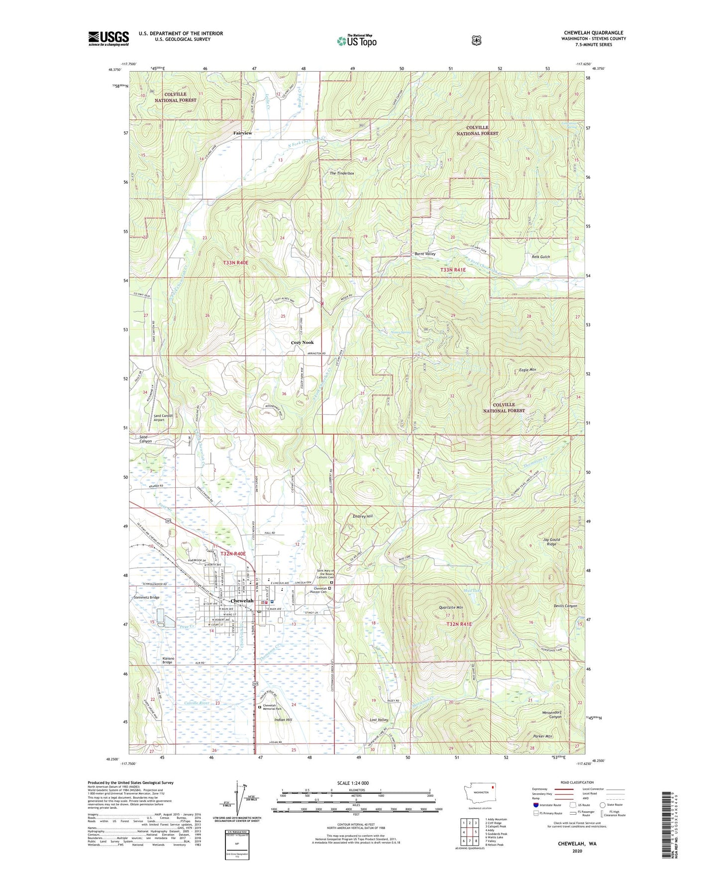
2020 topographic map quadrangle Chewelah in the state of Washington. Scale: 1:24000. Based on the newly updated USGS 7.5' US Topo map series, this map is in the following counties: Stevens. The map contains contour data, water features, and other items you are used to seeing on USGS maps, but also has updated roads and other features. This is the next generation of topographic maps. Printed on high-quality waterproof paper with UV fade-resistant inks.
Quads adjacent to this one:
West: Addy
Northwest: Addy Mountain
North: Cliff Ridge
Northeast: Calispell Peak
East: Goddards Peak
Southeast: Nelson Peak
South: Valley
Southwest: Waitts Lake
Contains the following named places: Amazon Mine, Bayley Creek, Blue Star Mine, Burnt Valley, Chewelah, Chewelah Airfield, Chewelah Baptist Church, Chewelah City Park, Chewelah Community Health Center, Chewelah Creek, Chewelah Division, Chewelah Elementary School, Chewelah Memorial Park, Chewelah Municipal Airport, Chewelah Municipal Center, Chewelah Museum, Chewelah Pioneer Cemetery, Chewelah Police Department, Chewelah Post Office, Chewelah Public Library, Chewelah Rural Ambulance, Chewelah Senior High School, Chewelah Seventh Day Adventist Church, Chewelah Silver Mine, Chewelah Standard Mine, Chewelah United Church of Christ, Chewelah Wastewater Treatment Plant, City of Chewelah, Copper Cliff Mine, Copper King Number 2 Mine, Copper Queen Mine, Cozy Nook, Devils Canyon, Eagle Mountain, Embrey Hill, Fairview, Faith Community Church, Gardners Mobile Home Park, Gess Elementary School, Hartill's Ridgecrest Mobile Home Park, Hecla Mine, High Grade Mine, Imperial Copper Mine, Indian Hill, Jay Gould Mine, Jenkins Junior / Senior High School, Jenkins Middle School, Juno-Echo Mine, Keystone Mine, Kingdom Hall of Jehovahs Witnesses, Klavano Bridge, Leslie Creek, Limestone Spring, Lost Valley, McPherson Mine, Mud Lake, Mullen Mine, Nance Spring, North Fork Chewelah Creek, Parker Mountain, Paye Creek, Payne Mine, Providence Saint Joseph's Hospital, Quartzite Mountain, Reik Gulch, Ridgecrest Mobile Home Park, Saint Joseph Hospital of Chewelah Long Term Care Facility, Saint Josephs Hospital Airport, Saint Mary of the Rosary Catholic Cemetery, Saint Paul Lutheran Church, Sand Canyon, Security Copper Mine, Sixmile Creek, South Fork Chewelah Creek, Steinmetz Bridge, Stevens County Fire District 4 Station 43 Chewelah City, Stevens County Fire District 4 Station 44 Moser Road, Steven's Street Mobile Home Park, Success Mine, The Tinderbox, Thomason Creek, United Copper Number 1 Mine, United Copper Number 2 Mine, Windfall Mine, ZIP Code: 99109