MyTopo
Friday Harbor Washington US Topo Map
Couldn't load pickup availability
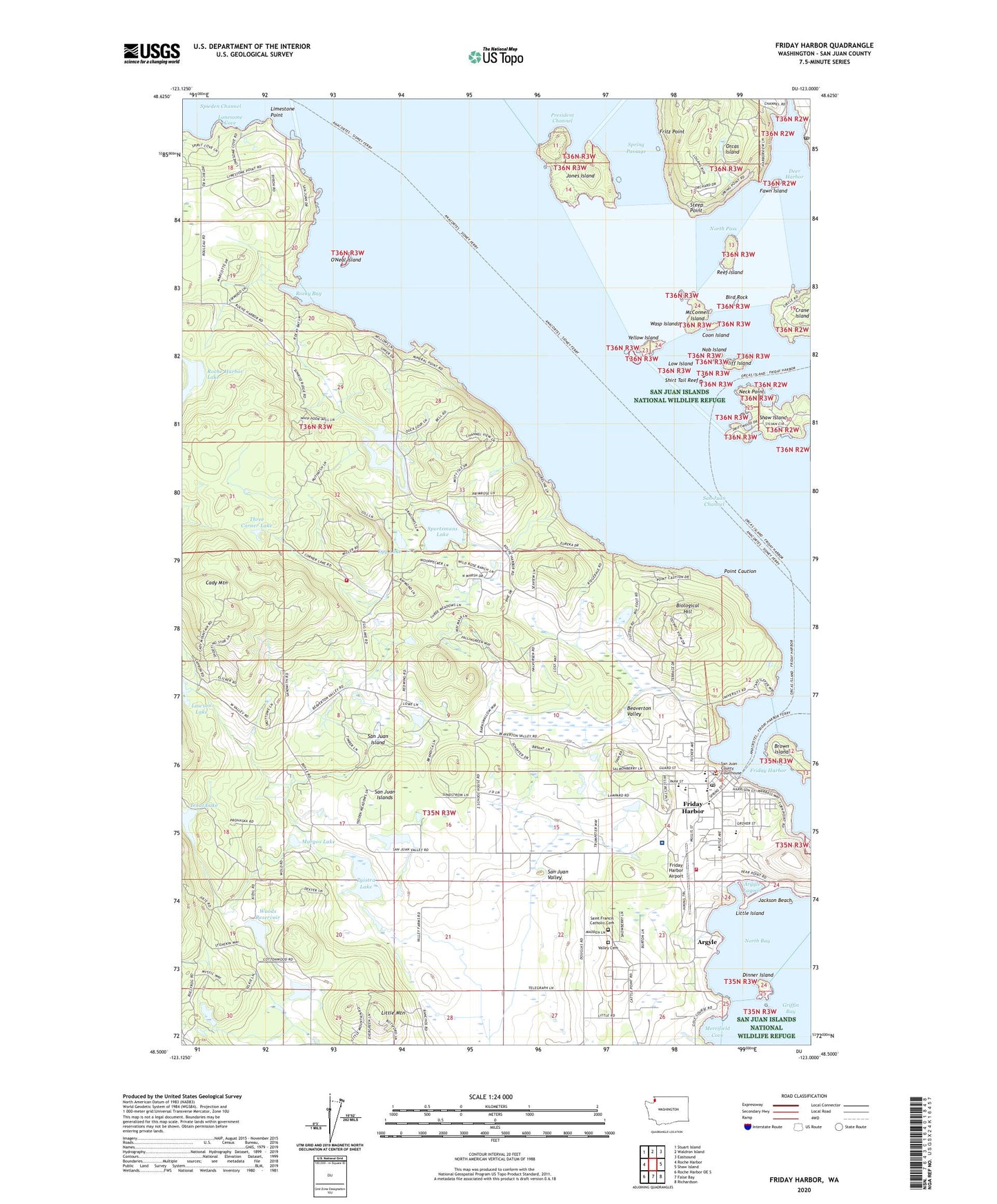
2020 topographic map quadrangle Friday Harbor in the state of Washington. Scale: 1:24000. Based on the newly updated USGS 7.5' US Topo map series, this map is in the following counties: San Juan. The map contains contour data, water features, and other items you are used to seeing on USGS maps, but also has updated roads and other features. This is the next generation of topographic maps. Printed on high-quality waterproof paper with UV fade-resistant inks.
Quads adjacent to this one:
West: Roche Harbor
Northwest: Stuart Island
North: Waldron Island
Northeast: Eastsound
East: Shaw Island
Southeast: Richardson
South: False Bay
Southwest: Roche Harbor OE S
Contains the following named places: Argyle, Argyle Lagoon, Beaverton Valley, Biological Hill, Bird Rock, Boyce Dam, Brown Island, Burton and Louthan Dam, Cady Mountain, Cayou Quay Marina, Children's House Montessori School, Circle Park, Cliff Island, Coon Island, Deer Harbor, Deer Harbor Marina, Deer Harbor Post Office, Dinner Island, Durhack Dam Number Five, Durhack Dam Number Four, Durhack Dam Number One, Durhack Dam Number Seven, Durhack Dam Number Six, Durhack Dam Number Three, Durhack Dam Number Two, Egg Lake, Erickson Dam Number One, Erickson Dam Number Two, Fawn Island, Friday Harbor, Friday Harbor Airport, Friday Harbor Elementary School, Friday Harbor Ferry Landing, Friday Harbor Fire Department, Friday Harbor High School, Friday Harbor Middle School, Friday Harbor Post Office, Friday Harbor Presbyterian Church, Friday Harbor Quarry, Friday Harbor Seaplane Base, Friday Harbor Seventh Day Adventist Church, Friday Harbor Sewage Treatment Plant, Friday West Airport, Fritz Point, Griffin Bay Learning Center, Heidenreich Dam, Islands Community Church, Islands Convalescent Center, Jackson Beach, Jones Island, Jones Island Marina, Jones Island State Park National Wildlife Refuge, Kingdom Hall of Jehovahs Witnesses, Lakedale, Lawson Lake, Lawson Lake Dam, Limestone Point, Little Island, Little Mountain, Lonesome Cove, Low Island, Margos Lake, Margos Lake Dam, McConnell Island, Merrifield Cove, Neck Point, Nob Island, North Bay, North Pass, Oceanographic Laboratories, Old American Legion Hall, O'Neal Island, Point Caution, Port of Friday Harbor, Reef Island, Roche Harbor Lake, Rocky Bay, Saint David's Episcopal Church, Saint Francis Catholic Cemetery, Saint Francis Parish Catholic Church, Saint Francis Xavier Mission, San Juan Channel, San Juan County Courthouse, San Juan County Courthouse Annex, San Juan County Sheriff's Office, San Juan Historical Museum, San Juan Island, San Juan Island Dam Number One, San Juan Island Dam Number Two, San Juan Island Division, San Juan Island Emergency Medical Services Frank Wilson Emergency Medical Services Building, San Juan Island Fire Department Eagle Crest Station 36, San Juan Island Fire Department Friday Harbor Station 31, San Juan Island Library, San Juan Island Transfer Station Solid Waste Facility, San Juan Island Yacht Club, San Juan Islands Museum of Art, Schuman Dam, Seattle Yacht Club Friday Harbor Outstation, Shirt Tail Reef, Sportsman Lake Dam, Sportsmans Lake, Spring Passage, Spring Street International School, Steep Point, Stillpoint School, Sundstrom Dam, The Church of Jesus Christ of Latter Day Saints, Three Corner Lake, Town of Friday Harbor, Trout Lake Storage Dam, Trout Lake Water Supply Dam, Valley Cemetery, Warbass Way Marina, Wasp Islands, Wasp Passage, Whale Museum, Woods Reservoir, Woods Reservoir Dam, Yellow Island, Zyistra Lake, Zylstra Dam, ZIP Codes: 98243, 98250