MyTopo
Shaw Island Washington US Topo Map
Couldn't load pickup availability
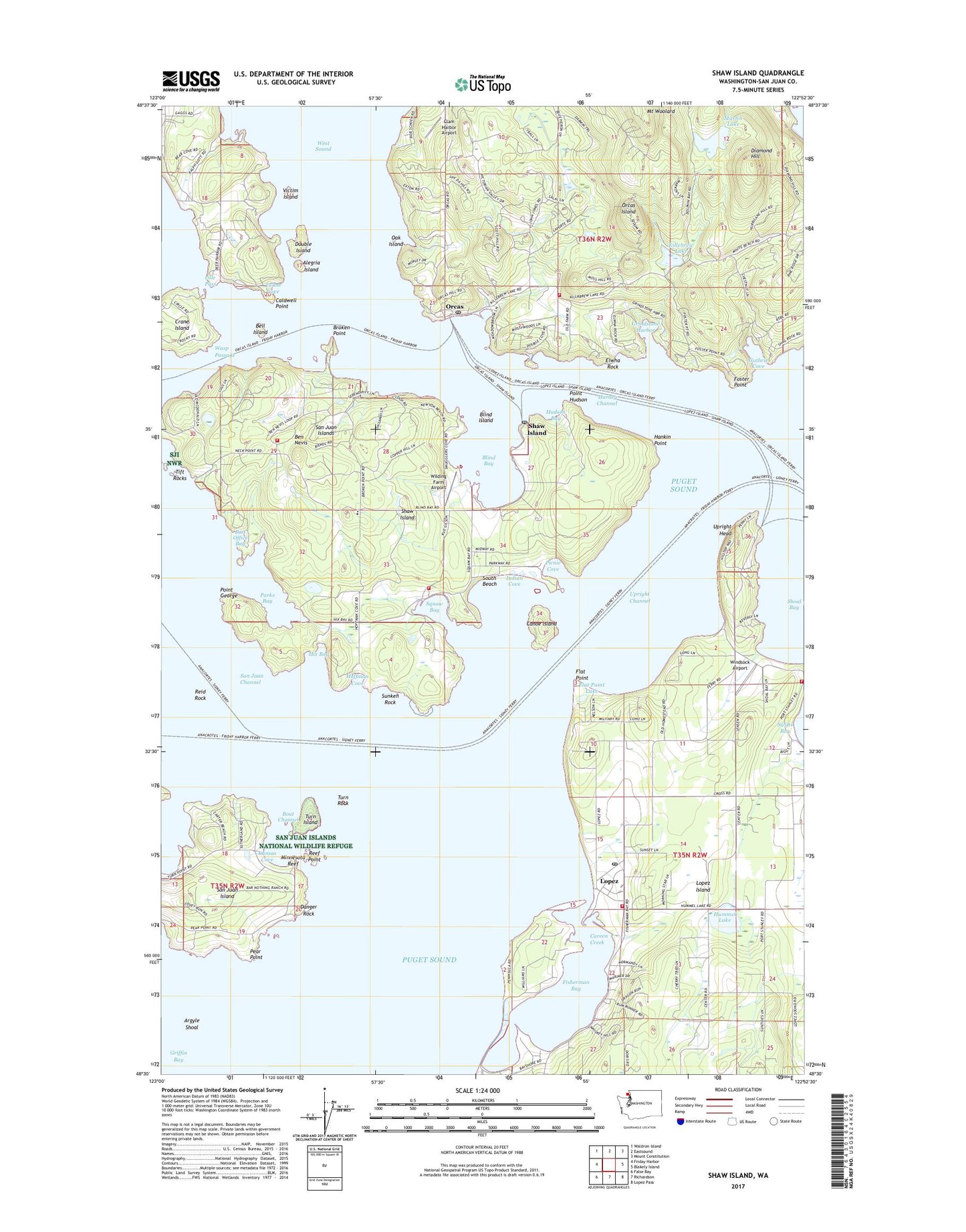
2023 topographic map quadrangle Shaw Island in the state of Washington. Scale: 1:24000. Based on the newly updated USGS 7.5' US Topo map series, this map is in the following counties: San Juan. The map contains contour data, water features, and other items you are used to seeing on USGS maps, but also has updated roads and other features. This is the next generation of topographic maps. Printed on high-quality waterproof paper with UV fade-resistant inks.
Quads adjacent to this one:
West: Friday Harbor
Northwest: Waldron Island
North: Eastsound
Northeast: Mount Constitution
East: Blakely Island
Southeast: Lopez Pass
South: Richardson
Southwest: False Bay
This map covers the same area as the classic USGS quad with code o48122e8.
Contains the following named places: Albert Jensen and Sons Marina, Alegria Island, Argyle Shoal, Bay Head Marina, Bell Island, Ben Nevis, Blind Bay, Blind Island, Boat Channel, Broken Point, Caldwell Point, Canoe Island, Careen Creek, Clam Harbor Airport, Crane Island, Danger Rock, Deer Harbor, Diamond Hill, Double Island, Elwha Rock, Evans Cove, Fisherman Bay, Fisherman Bay Sewage Treatment Plant, Fishermans Bay Seaplane Base, Flat Point, Flat Point Lake, Foster Point, Gagne Dam, Grant Dam, Grindstone Harbor, Guthrie Cove, Hankin Point, Harney Channel, Hilen Dam, Hix Bay, Hoffman Cove, Hudson Bay, Humes Dam, Hummel Lake, Indian Cove, Islands Marine Center Marina, Jacobson's at Orcas Landing, Johnson Dam, Kansas Cove, Killebrew Lake, Lopez, Lopez Ferry Landing, Lopez Island Children's Center, Lopez Island Community Center, Lopez Island Community Church, Lopez Island Historical Museum, Lopez Island Library, Lopez Island Post Office, Lopez Island Transfer Station Solid Waste Facility, Lopez Islander Marina, Lopez Village, Martin Lake, Martins Lake Dam, Minnesota Reef, Morehouse Dam, Oak Island, Odlin County Park, Odlin County Park Campground, Orcas, Orcas Ferry Landing, Orcas Post Office, Osprey Pond, Parks Bay, Pear Point, Picnic Cove, Point George, Point Hudson, Pole Pass, Pole Pass Light, Post Office Bay, Reef Net Bay, Reef Point, Reid Rock, Samish Tribal Designated Statistical Area, San Juan County, San Juan County Fire District 2 / Orcas Island Fire and Rescue Station 26 Orcas, San Juan County Fire District 5 Shaw Island Volunteer Fire Department, San Juan County Fire Protection District 4 Station 41, San Juan County Fire Protection District 4 Station 43, San Juan County Sheriff's Office Lopez Substation, San Juan Islands, Shag Rock, Shaw County Park, Shaw Ferry Landing, Shaw Island, Shaw Island Cemetery, Shaw Island County Park, Shaw Island County Park Campground, Shaw Island Elementary School, Shaw Island Post Office, Shipyard Cove Marina, Shoal Bay, South Beach, Sunken Rock, Tharald Pond, Tift Rocks, Turn Island, Turn Island State Park, Turn Rock, Turn Rock Light, Upright Channel, Upright Head, Victim Island, Victim Island State Park, Warrack Dam Number One, Warrack Dam Number Two, Wasp Passage Light, West Sound, Wilding Farm Airport, Windsock Airport, ZIP Codes: 98280, 98286